Lagos is a municipality at the mouth of Bensafrim River and along the Atlantic Ocean, in the Barlavento region of the Algarve, in southern Portugal. The population in 2011 was 31,049, in an area of 212.99 km². The main town of Lagos has a population of approximately 22,000. Typically, these numbers increase during the summer months, with the influx of visiting tourists and seasonal residents. While the majority of the population lives along the coast and works in tourism and services, the inland region is sparsely inhabited, with the majority of the people working in agriculture and forestry.

Praia da Rocha Baixinha or Praia dos Tomates is a beach within the Municipality of Albufeira, in the Algarve, Portugal. The beach is 13 kilometres (8.1 mi) east of the town of Albufeira and is 31.7 kilometres (19.7 mi) west of the regions capital of Faro. In 2012 Praia da Rocha Baixinha was designated a blue Flag beach.

Praia de Odeceixeis is a beach and small settlement within the Municipality of Aljezur, in the Algarve, Portugal. The beach is on the western seaboard in the extreme north west of the Algarve. It is in the Vicentine Coast Natural Park. The beach is 2.1 miles (3.4 km) west of the village of Odeceixe, and is 77.9 miles (125.4 km) north west, by road, from the region's capital of Faro. In 2012 Praia de Odeceixe was designated a blue Flag beach.

Praia Santa Eulália is a beach within the Municipality of Albufeira, in the Algarve, Portugal. The beach is 2.7 miles (4.3 km) east of the town of Albufeira and is 20.5 miles (33.0 km) west of the regions capital of Faro. In 2012 Praia Santa Eulália has been designated a blue Flag beach.

Praia do Evaristo is a beach within the Municipality of Albufeira, in the Algarve, Portugal. The beach is 3.8 miles (6.1 km) west of the town of Albufeira and is 31.3 miles (50.4 km) west of the regions capital of Faro. In 2012 Praia do Evaristo has been designated a Blue Flag Beach.
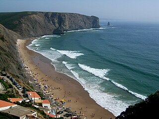
Praia da Arrifana is a beach within the Municipality of Aljezur, in the Algarve, Portugal. The beach is on the western Seaboard in the north west of the Algarve. The beach is 6.0 miles (9.7 km) south south west of the village of Aljezur, and is 71.0 miles (114.3 km) north west, by road, from the regions capital of Faro. The beach of Praia da Arrifana is inside the Vicentine Coast Natural Park, an area of outstanding natural beauty. Praia da Arrifana has been designated a blue Flag beach (2012).
Praia da Baía dos Tiros is a beach within the Municipality of Aljezur, in the Algarve, Portugal. The beach is on the western Seaboard in the extreme north-west of the Algarve. It is inside the Vicentine Coast Natural Park. The beach is 2.2 miles (3.5 km) north-west of the village of Maria Vinagre, and is 74.2 miles (119.4 km) north-west, by road, from the regions capital of Faro.
Praia da Coelha is a beach close to the village resort of Sesmarias which is within the Municipality of Albufeira, in the Algarve, Portugal. This beach is located 3.9 miles (6.3 km) by road to the west of Albufeira old town centre and is 31.5 miles (50.7 km) west of the region's capital, Faro. This beach is one of 69e blue flag beaches (2012) in the Algarve

Praia de São Rafael is a beach on the Atlantic south coast of the Algarve, close to the village resort of Sesmarias which is within the Municipality of Albufeira, Portugal. This beach is located 2.5 miles (4.0 km) by road to the west of Albufeira old town centre and is 29.7 miles (47.8 km) west of the regions capital of Faro. This beach is one of sixty nine blue flag beaches (2012) in the Algarve and is accredited with good facilities for the disabled.

Praia dos Arrifes is a beach on the Atlantic south coast of the Algarve, close to the village resort of Sesmarias which is within the Municipality of Albufeira, Portugal. This beach is located 2.4 miles (3.9 km) by road to the west of Albufeira old town centre and is 29.6 miles (47.6 km) west of the regions capital of Faro. This beach is one of sixty nine blue flag beaches (2012) in the Algarve

Praia do Túnel is a beach on the Atlantic south coast of the Algarve, in the town of Albufeira which is within the Municipality of Albufeira, Portugal. The beach is also known as Praia do Peneco and is one of the two beaches which front the town of Albufeira with Praia do Túnel at the western end and Praia dos Pescadores lying to the eastern end of the towns seafront. The town and its beaches are located west 23.9 miles (38.5 km) by road of the regions capital of Faro.

Praia do Castelo is a beach close to the village resort of Sesmarias which is within the Municipality of Albufeira, in the Algarve, Portugal. This beach is located 4.0 miles (6.4 km) by road to the west of Albufeira old town centre and is 31.9 miles (51.3 km) west of the regions capital of Faro. This beach is one of sixty nine blue flag beaches (2012) in the Algarve.
Espiche River is a small river in the south central region of the Algarve, Portugal which rises a little south east of the village of Algoz. It runs south towards the south coast, and its mouth is at Praia dos Salgados between Armação de Pêra and Albufeira.

Barranco das Belharucas Beach is a beach in the municipality of Albufeira, Portugal, between Olhos de Água and Açoteias. It begins the Falesia Beach that extends for 7 km to Vilamoura.
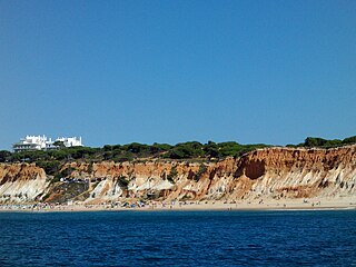
Falésia Beach is a beach in Albufeira, Algarve, southern Portugal. It has a cliff that begins in the Barranco das Belharucas Beach and extends to Vilamoura.

Praia dos Alemães is a blue flag beach located west of Albufeira old town and is flanked either side by Praia dos Aveiros to the west and to the east by Praia do Inatel.
Praia do Inatel is a Blue flag beach located in the resort town of Albufeira, Algarve, Portugal. The beach lies to the east of Albufeira old town in the district of Bairro dos Pescadores , and is dominated by the Albufeira Inatel Hotel which sit to the rear of the beach and from which the beach takes its name.

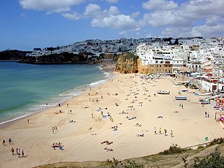
Praia dos Pescadores or the Fishermans Beach is a blue flag beach on the Atlantic south coast of the Algarve, in the district of Bairro dos Pescadores, Albufeira which is within the Municipality of Albufeira, Portugal. The beach is one of the two beaches which front the town of Albufeira with Praia do Túnel at the western end and Praia dos Pescadores lying to the eastern end of the towns seafront. The town and its beaches are located west 23.9 miles (38.5 km) by road of the regions capital of Faro.

Praia da Balaia is a small satellite beach at the eastern end of its larger neighbour, Praia Santa Eulália, on the Atlantic south coast of the Algarve. Its is within the municipality of Albufeira and is 3.1 kilometres (1.9 mi) east of the town of Albufeira and 1.7 kilometres (1.1 mi) west of the coastal village of Olhos de Água.