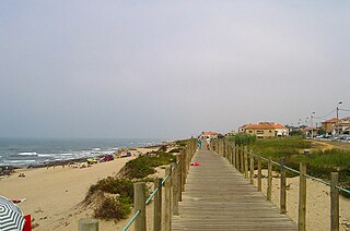
Praia da Granja is a FEE Blue Flag beach located in the Northwest of Portugal, and belongs to the Vila Nova de Gaia municipality, Porto District. This place is also located in the town of São Félix da Marinha. The northern boundary of the beach is bordered by the Ribeira da Granja.

Praia da Rocha Baixinha or Praia dos Tomates is a beach within the Municipality of Albufeira, in the Algarve, Portugal. The beach is 13 kilometres (8.1 mi) east of the town of Albufeira and is 31.7 kilometres (19.7 mi) west of the regions capital of Faro. In 2012 Praia da Rocha Baixinha was designated a blue Flag beach.

Praia de Odeceixe is a beach and small settlement within the Municipality of Aljezur, in the Algarve, Portugal. The beach is on the western seaboard in the extreme northwest of the Algarve. It is in the Vicentine Coast Natural Park. The beach is 2.1 miles (3.4 km) west of the village of Odeceixe, and is 77.9 miles (125.4 km) northwest, by road, of the region's capital of Faro. In 2012 Praia de Odeceixe was designated a blue Flag beach.

Praia do Vale dos Homens is a beach within the Municipality of Aljezur, in the Algarve, Portugal. The beach is on the western seaboard in the north west of the Algarve. The beach is 1.7 miles (2.7 km) north west of the village of Rogil, and is 72.4 miles (116.5 km) north west, by road, from the region's capital of Faro.

Praia Santa Eulália is a beach within the Municipality of Albufeira, in the Algarve, Portugal. The beach is 2.7 miles (4.3 km) east of the town of Albufeira and is 20.5 miles (33.0 km) west of the regions capital of Faro. In 2012 Praia Santa Eulália has been designated a blue Flag beach.

Praia do Evaristo is a beach within the Municipality of Albufeira, in the Algarve, Portugal. The beach is 3.8 miles (6.1 km) west of the town of Albufeira and is 31.3 miles (50.4 km) west of the regions capital of Faro. In 2012 Praia do Evaristo has been designated a Blue Flag Beach.

Praia da Amoreira is a beach within the Municipality of Aljezur, in the Algarve, Portugal. The beach is on the western Seaboard in the north west of the Algarve. The beach is 5.4 miles (8.7 km) north west of the village of Aljezur, and is 71.8 miles (115.6 km) north west, by road, from the regions capital of Faro.

Praia do monte Clérigo is a beach within the municipality of Aljezur, in Algarve, Portugal. The beach is on the western Seaboard in the north west of the Algarve. The beach is 5.1 miles (8.2 km) north west of the village of Aljezur, and is 70.0 miles (112.7 km) north west, by road, from the regions capital of Faro. Praia do monte Clérigohas been designated a blue Flag beach (2012).
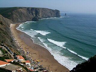
Praia da Arrifana is a beach within the Municipality of Aljezur, in the Algarve, Portugal. The beach is on the western Seaboard in the north west of the Algarve. The beach is 6.0 miles (9.7 km) south south west of the village of Aljezur, and is 71.0 miles (114.3 km) north west, by road, from the regions capital of Faro. The beach of Praia da Arrifana is inside the Vicentine Coast Natural Park, an area of outstanding natural beauty. Praia da Arrifana has been designated a blue Flag beach (2012).
Praia da Coelha is a beach close to the village resort of Sesmarias which is within the Municipality of Albufeira, in the Algarve, Portugal. This beach is located 3.9 miles (6.3 km) by road to the west of Albufeira old town centre and is 31.5 miles (50.7 km) west of the region's capital, Faro. This beach is one of 69e blue flag beaches (2012) in the Algarve

Praia de São Rafael is a beach on the Atlantic south coast of the Algarve, close to the village resort of Sesmarias which is within the Municipality of Albufeira, Portugal. This beach is located 2.5 miles (4.0 km) by road to the west of Albufeira old town centre and is 29.7 miles (47.8 km) west of the regions capital of Faro. This beach is one of sixty nine blue flag beaches (2012) in the Algarve and is accredited with good facilities for the disabled.

Praia dos Arrifes is a beach on the Atlantic south coast of the Algarve, close to the village resort of Sesmarias which is within the Municipality of Albufeira, Portugal. This beach is located 2.4 miles (3.9 km) by road to the west of Albufeira old town centre and is 29.6 miles (47.6 km) west of the regions capital of Faro. This beach is one of sixty nine blue flag beaches (2012) in the Algarve.

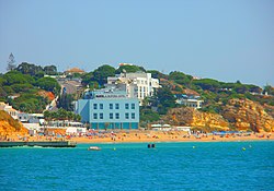
Praia do Túnel is a beach on the Atlantic south coast of the Algarve, in the town of Albufeira which is within the Municipality of Albufeira, Portugal. The beach is also known as Praia do Peneco and is one of the two beaches which front the town of Albufeira with Praia do Túnel at the western end and Praia dos Pescadores lying to the eastern end of the towns seafront. The town and its beaches are located west 23.9 miles (38.5 km) by road of the regions capital of Faro.

Praia do Castelo is a beach close to the village resort of Sesmarias which is within the Municipality of Albufeira, in the Algarve, Portugal. This beach is located 4.0 miles (6.4 km) by road to the west of Albufeira old town centre and is 31.9 miles (51.3 km) west of the regions capital of Faro. This beach is one of sixty nine blue flag beaches (2012) in the Algarve.

Praia da Oura is a blue flag beach within the Municipality of Albufeira, in the Algarve, Portugal. The beach is in the eastern district of Albufeira in the neighbourhood called Areias de São João. Its flanked by Praia dos Aveiros to the west and Praia de Santa Eulália to the eastern side. The beach is approximately 900 metres (3,000 ft) in length and is 450 metres (1,480 ft) wide at low tide.

Barranco das Belharucas Beach is a beach in the municipality of Albufeira, Portugal, between Olhos de Água and Açoteias. It begins the Falesia Beach that extends for 7 km to Vilamoura.

Praia dos Aveiros is a small blue flag beach in the area called Areias de São João or Saint John's Sands, in the town of Albufeira, Algarve, Portugal. The beach is enclosed in a small cove and is made up of fine golden sands and is flanked at either end by cliffs and rock formations.

Praia dos Alemães is a blue flag beach located west of Albufeira old town and is flanked either side by Praia dos Aveiros to the west and to the east by Praia do Inatel.

Praia dos Pescadores or the Fishermans Beach is a blue flag beach on the Atlantic south coast of the Algarve, in the district of Bairro dos Pescadores, Albufeira which is within the Municipality of Albufeira, Portugal. The beach is one of the two beaches which front the town of Albufeira with Praia do Túnel at the western end and Praia dos Pescadores lying to the eastern end of the towns seafront. The town and its beaches are located west 23.9 miles (38.5 km) by road of the regions capital of Faro.
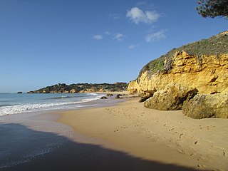
Praia da Balaia is a small satellite beach at the eastern end of its larger neighbour, Praia Santa Eulália, on the Atlantic south coast of the Algarve. It is within the municipality of Albufeira and is 3.1 kilometres (1.9 mi) east of the town of Albufeira and 1.7 kilometres (1.1 mi) west of the coastal village of Olhos de Água.