Odeceixe is a village and civil parish in the northern part of the municipality of Aljezur, in the Portuguese Algarve, lying within the Nature Park of the Southwest Alentejo and Vincentine Coast. The village lies on the south bank of the Ribeira de Seixe, which here forms the border between the Algarve and Alentejo. The population of the parish in 2011 was 961, in an area of 41.91 km².

Aljezur is a municipality in Portugal. The population in 2011 was 5,884, in an area of 323.50 km². The municipality comprises 4 parishes, and is located within the district of Faro.

Carrapateira is a village on the western coast of the Algarve, Portugal. Administratively, it is part of the civil parish of Bordeira, within the municipality of Aljezur, in the Faro District. Its landmarks include an old fort and a church. The nearby beaches are a popular surfing destination.

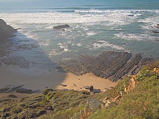
Praia de Odeceixeis is a beach and small settlement within the Municipality of Aljezur, in the Algarve, Portugal. The beach is on the western seaboard in the extreme north west of the Algarve. It is in the Vicentine Coast Natural Park. The beach is 2.1 miles (3.4 km) west of the village of Odeceixe, and is 77.9 miles (125.4 km) north west, by road, from the region's capital of Faro. In 2012 Praia de Odeceixe was designated a blue Flag beach.

Praia de Samouqueira a beach within the Municipality of Aljezur, in the Algarve, Portugal. The beach is on the western Seaboard in the extreme north west of the Algarve. The beach is 2.3 miles (3.7 km) north west of the village and municipality of Rogil, and is 73 miles (117 km) north west, by road, from the regions capital of Faro.
Praia do Vale dos Homens is a beach within the Municipality of Aljezur, in the Algarve, Portugal. The beach is on the western Seaboard in the north west of the Algarve. The beach is 1.7 miles (2.7 km) north west of the village of Rogil, and is 72.4 miles (116.5 km) north west, by road, from the regions capital of Faro.
Praia da Carreagem is a beach within the Municipality of Aljezur, in the Algarve, Portugal. The beach is on the western Seaboard in the north west of the Algarve. The beach is 2.6 miles (4.2 km) west of the village of Rogil, and is 71.8 miles (115.6 km) north west, by road, from the regions capital of Faro. The beach is inside the Vicentine Coast Natural Park.

Praia da Amoreira is a beach within the Municipality of Aljezur, in the Algarve, Portugal. The beach is on the western Seaboard in the north west of the Algarve. The beach is 5.4 miles (8.7 km) north west of the village of Aljezur, and is 71.8 miles (115.6 km) north west, by road, from the regions capital of Faro.

Praia do monte Clérigo is a beach within the Municipality of Aljezur, in the Algarve, Portugal. The beach is on the western Seaboard in the north west of the Algarve. The beach is 5.1 miles (8.2 km) north west of the village of Aljezur, and is 70.0 miles (112.7 km) north west, by road, from the regions capital of Faro. Praia do monte Clérigohas been designated a blue Flag beach (2012).
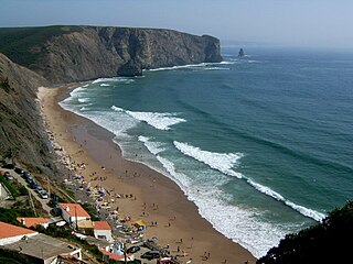
Praia da Arrifana is a beach within the Municipality of Aljezur, in the Algarve, Portugal. The beach is on the western Seaboard in the north west of the Algarve. The beach is 6.0 miles (9.7 km) south south west of the village of Aljezur, and is 71.0 miles (114.3 km) north west, by road, from the regions capital of Faro. The beach of Praia da Arrifana is inside the Vicentine Coast Natural Park, an area of outstanding natural beauty. Praia da Arrifana has been designated a blue Flag beach (2012).
Praia da Pipa is a beach within the Municipality of Aljezur, in the Algarve, Portugal. The beach is on the western Seaboard in the north west of the Algarve. The beach is 6.8 miles (10.9 km) south south west of the village of Aljezur, and is 71.7 miles (115.4 km) north west, by road, from the regions capital of Faro. The beach of Praia da Pipa is inside the Vicentine Coast Natural Park, an area of outstanding natural beauty.
Praia do Canal is a beach within the Municipality of Aljezur, in the Algarve, Portugal. The beach is on the western Seaboard in the north west of the Algarve. The beach is 6.7 miles (10.8 km) south west of the village of Aljezur, and is 65.6 miles (105.6 km) north west, by road, from the regions capital of Faro. The beach of Praia do Canal is inside the Vicentine Coast Natural Park, an area of outstanding natural beauty.
Praia de Vale Figueira is a beach within the Municipality of Aljezur, in the Algarve, Portugal. The beach is on the western Seaboard in the north west of the Algarve. The beach is 9.1 miles (14.6 km) south west of the village of Aljezur, and is 66.6 miles (107.2 km) north west, by road, from the regions capital of Faro. The beach of Praia de Vale Figueira is inside the Vicentine Coast Natural Park, an area of outstanding natural beauty.
Praia da Baía dos Tiros is a beach within the Municipality of Aljezur, in the Algarve, Portugal. The beach is on the western Seaboard in the extreme north-west of the Algarve. It is inside the Vicentine Coast Natural Park. The beach is 2.2 miles (3.5 km) north-west of the village of Maria Vinagre, and is 74.2 miles (119.4 km) north-west, by road, from the regions capital of Faro.
Praia da Coelha is a beach close to the village resort of Sesmarias which is within the Municipality of Albufeira, in the Algarve, Portugal. This beach is located 3.9 miles (6.3 km) by road to the west of Albufeira old town centre and is 31.5 miles (50.7 km) west of the region's capital, Faro. This beach is one of 69e blue flag beaches (2012) in the Algarve

Praia de São Rafael is a beach on the Atlantic south coast of the Algarve, close to the village resort of Sesmarias which is within the Municipality of Albufeira, Portugal. This beach is located 2.5 miles (4.0 km) by road to the west of Albufeira old town centre and is 29.7 miles (47.8 km) west of the regions capital of Faro. This beach is one of sixty nine blue flag beaches (2012) in the Algarve and is accredited with good facilities for the disabled.

Praia do Castelo is a beach close to the village resort of Sesmarias which is within the Municipality of Albufeira, in the Algarve, Portugal. This beach is located 4.0 miles (6.4 km) by road to the west of Albufeira old town centre and is 31.9 miles (51.3 km) west of the regions capital of Faro. This beach is one of sixty nine blue flag beaches (2012) in the Algarve.

Praia dos Aveiros is a small blue flag beach in the area called Areias de São João or Saint John's Sands, in the town of Albufeira, Algarve, Portugal. The beach is enclosed in a small cove and is made up of fine golden sands and is flanked at either end by cliffs and rock formations.

Praia dos Pescadores or the Fishermans Beach is a blue flag beach on the Atlantic south coast of the Algarve, in the district of Bairro dos Pescadores, Albufeira which is within the Municipality of Albufeira, Portugal. The beach is one of the two beaches which front the town of Albufeira with Praia do Túnel at the western end and Praia dos Pescadores lying to the eastern end of the towns seafront. The town and its beaches are located west 23.9 miles (38.5 km) by road of the regions capital of Faro.
Praia da Balaia is a small satellite beach at the eastern end of its larger neighbour, Praia Santa Eulália, on the Atlantic south coast of the Algarve. Its is within the municipality of Albufeira and is 3.1 kilometres (1.9 mi) east of the town of Albufeira and 1.7 kilometres (1.1 mi) west of the coastal village of Olhos de Água.