
Southeast Alaska, colloquially referred to as the Alaska(n) Panhandle, is the southeastern portion of the U.S. state of Alaska, bordered to the east and north by the northern half of the Canadian province of British Columbia. The majority of Southeast Alaska's area is part of the Tongass National Forest, the United States' largest national forest. In many places, the international border runs along the crest of the Boundary Ranges of the Coast Mountains. The region is noted for its scenery and mild, rainy climate.

Hyder is a census-designated place in Prince of Wales-Hyder Census Area, Alaska, United States. The population was 87 at the 2010 census, down from 97 in 2000. Hyder is accessible by road only from Stewart, British Columbia, and is popular with motorists wishing to visit Alaska without driving the length of the Alaska Highway and is otherwise landlocked. It is the southernmost community in the state that can be reached via car. Hyder is Alaska's easternmost town.

The Stikine River is a major river in northern British Columbia, Canada and southeastern Alaska in the United States. It drains a large, remote upland area known as the Stikine Country east of the Coast Mountains. Flowing west and south for 610 kilometres (379 mi), it empties into various straits of the Inside Passage near Wrangell, Alaska. About 90 percent of the river's length and 95 percent of its drainage basin are in Canada. Considered one of the last truly wild large rivers in British Columbia, the Stikine flows through a variety of landscapes including boreal forest, steep canyons and wide glacial valleys.

Portland Canal is an arm of Portland Inlet, one of the principal inlets of the British Columbia Coast. It is approximately 114 km (71 mi) long. The Portland Canal forms part of the border between southeastern Alaska and British Columbia. The name of the entire inlet in the Nisga'a language is Kʼalii Xkʼalaan, with xkʼalaan meaning "at the back of (someplace)". The upper end of the inlet was home to the Tsetsaut, who after being decimated by war and disease were taken under the protection of the Laxsgiik (Eagle) chief of the Nisga'a, who holds the inlet's title in native law.

Stewart is a district municipality at the head of the Portland Canal in northwestern British Columbia, Canada, near the Alaskan panhandle. In 2011, its population was about 494.

The Salmon River is a braided stream that flows through Hyder, Alaska, and empties into the Portland Canal. It is fed by meltwater from the Salmon Glacier, which is located within British Columbia approximately 13 miles north of its confluence into the Canal and is road-accessible from the town of Stewart, British Columbia. The river crosses the Canada–United States border at 56°02′00″N130°02′00″W.

Tatshenshini-Alsek Park or Tatshenshini-Alsek Provincial Wilderness Park is a provincial park in British Columbia, Canada 9,580 km2 (3,700 sq mi). It was established in 1993 after an intensive campaign by Canadian and American conservation organizations to halt mining exploration and development in the area, and protect the area for its strong natural heritage and biodiversity values.
Thutade Lake is located in the Omineca Mountains of the Northern Interior of British Columbia, Canada. About 40 km (25 mi) in length, and no more than about 2 km (1.2 mi) wide, the lake is primarily significant as the ultimate source of the Mackenzie River. The lake is at the head of the Finlay River, which joins the Peace River via Williston Lake. The area is very remote, being located about 260 km (160 mi) north of Smithers, although several mining operations for ores containing copper, lead, zinc and silver have occurred around the lake. The largest of these is the Kemess Mine, an iron and copper property originally owned by Royal Oak Mines and now by Northgate Minerals, located in the valley of Kemess Creek, which is off the northeast end of Thutade Lake. The mine is accessed by the Omineca Resource Road and other resource routes, and is 400 km (250 mi) by road from Prince George. Just downstream from the outlet of Thutade Lake, the Finlay plunges over the 180-foot (55 m) Cascadero Falls, and then through a series of cataracts in a twisting course until it begins its main northeastward trend. Cascadero Falls is slated for hydroelectric development in connection with the power needs of the area's mines.

Hoodoo Mountain, sometimes referred to as Hoodoo Volcano, is a potentially active stratovolcano in the Northern Interior of British Columbia, Canada. It is located 25 kilometres northeast of the Alaska–British Columbia border on the north side of the Iskut River opposite of the mouth of the Craig River. With a summit elevation of 1,850 metres and a topographic prominence of 900 metres , Hoodoo Mountain is one of many prominent peaks within the Boundary Ranges of the Coast Mountains. Its flat-topped summit is covered by an ice cap more than 100 metres thick and at least 3 kilometres in diameter. Two valley glaciers surrounding the northwestern and northeastern sides of the mountain have retreated significantly over the last hundred years. They both originate from a large icefield to the north and are the sources of two meltwater streams. These streams flow along the western and eastern sides of the volcano before draining into the Iskut River.
Black Dome Mountain is the northernmost summit of the Camelsfoot Range, which lies along the west side of the Fraser River, north of Lillooet, British Columbia, Canada. It is an ancient butte-like volcano located in the formation known as the Chilcotin Group, which lie between the Pacific Ranges of the Coast Mountains and the mid-Fraser River in British Columbia, Canada.

The Salmon Glacier is a glacier located ~25 km (16 mi) north of Stewart, British Columbia, and Hyder, Alaska, just on the Canadian side of the border. The glacier, one of hundreds in the Boundary Ranges, is notable for its major potential as a natural hazard. Summit Lake is located at the northern end of the glacier and every year around mid-July the lake breaks an ice-dam and then flows under the Salmon Glacier into the Salmon River. This causes the river to rise approximately 4–5 ft (1.2–1.5 m) for several days.
British Columbia Highway 37A, which is known as the Stewart Highway and also as the Glacier Highway, is a 65 km (40 mi) long spur of Highway 37 west from Meziadin Junction to the border towns of Stewart and Hyder, Alaska, where it connects with Alaska's Salmon River Road. It was first built in the early 1960s to facilitate the movement of asbestos from the town of Cassiar. The Highway 37A designation was assigned in 1984.
Tasu or Tassoo, also Old Tasu or Old Tasu Townsite, was an iron and copper open pit and underground mining operation and townsite located on the south shore of Tasu Sound in west-central Moresby Island in the Queen Charlotte Islands of the North Coast of British Columbia, Canada. It ran from 1918 until the early 1980s, with the townsite growing full size in the early 1960s. The early iron mine was owned and worked by Japanese miners, with the mine finishing operation as Wesfrob Mine, owned by Falconbridge Nickel Mines.
McGillivray, formerly McGillivray Falls, is an unincorporated recreational community on the west shore of Anderson Lake, just east of midway between the towns of Pemberton and Lillooet, British Columbia, Canada, in that province's southwest Interior.
Walter Muma is a Canadian man who is on record for completing a 3-month 11,500-mile (18,660 km) journey across Canada and Alaska by moped. The journey took place during the summer of 1978, began in Toronto, passed through Yukon and Alaska, continued up the Dempster Highway to Inuvik, Northwest Territories, and finally back to Toronto.
Vital Creek is a creek located in the Omineca Country region of British Columbia, flowing eastward from its source in the Vital Range to meet Silver Creek, joining that creek from the west about 5 miles from its mouth into the Omineca River, about 41 km northeast of Takla Landing.
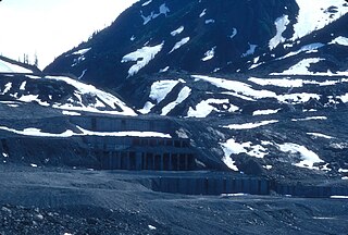
Overlooking the Salmon Glacier, the Granduc Mine is a large copper mine which is situated on a rock ridge between a glacier and a cliff, some 22 miles (35 km) north of Stewart, BC at the north end of Summit Lake. It was an active mine from 1964 to 1984, having closed due to low copper prices.

Mount Bayard is a 1,999-metre (6,558 ft) glaciated mountain located in the Boundary Ranges on the international boundary line of Alaska and British Columbia. It is situated 22 kilometres (14 mi) north-northwest of Stewart, 10 km (6 mi) southeast of Mount White-Fraser, and 3.4 km (2 mi) east of Mount Lindeborg, which is its nearest higher peak. Precipitation runoff from the peak and meltwater from the Boundary and Salmon Glaciers that surround the peak drains into the Salmon River. Mount Lindeborg was the name adopted for this feature in 1921, however by 1924 it was renamed Mount Bayard in lieu of Lindeborg. The Mount Lindeborg name was transferred to the peak 3.4 km (2 mi) immediately west. Mount Bayard was named by the International Boundary Commission for Thomas F. Bayard (1828-1898), a diplomat and United States Senator. The mountain's name was officially adopted July 31, 1927, by the Geographical Names Board of Canada. The mountain is also known as Boundary Peak 15. Weather permitting, the mountain can be seen from the gravel Granduc Mine Road at Hyder, Alaska.
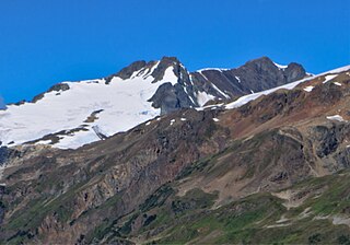
Mount White-Fraser is a 2,331 metres (7,648 ft) glaciated mountain located in the Boundary Ranges of British Columbia, Canada. It is situated 31 kilometres (19 mi) north-northwest of Stewart, and 10 km (6 mi) northwest of Mount Bayard. Precipitation runoff from the peak and meltwater from the surrounding Salmon Glacier drains into the Salmon River. The mountain was named by the International Boundary Survey for one of its own members, George White-Fraser (1872-1920), who also served with the Canadian Infantry in France during World War I. The mountain's name was officially adopted March 31, 1924. Weather permitting, the mountain can be seen from the gravel Granduc Mine Road near Hyder, Alaska, which is seasonally open in summer.
