Presumpscot Formation

Last updated

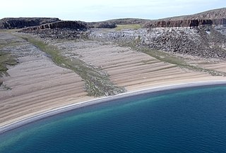
The Presumpscot formation is a late Pleistocene glacial deposit of predominantly submarine clays, located along the Maine and New Hampshire coast and inland along their major river valleys. It consists of primarily silt- and clay-sized particles formed from the glacial abrasion of the feldspars, quartz, and micas of the region, carried by glacial meltwater and deposited below sea level before subsequent crust rising (isostatic rebound) elevated the deposits up to more than 300 feet (91 m). It is named after the Presumpscot River where large amounts of the characteristic blue-gray clay are found.

The Pleistocene is the geological epoch which lasted from about 2,588,000 to 11,700 years ago, spanning the world's most recent period of repeated glaciations. The end of the Pleistocene corresponds with the end of the last glacial period and also with the end of the Paleolithic age used in archaeology.

Maine State of the United States of America

Maine is a state in the New England region of the northeastern United States. Maine is the 12th smallest by area, the 9th least populous, and the 38th most densely populated of the 50 U.S. states. It is bordered by New Hampshire to the west, the Atlantic Ocean to the southeast, and the Canadian provinces of New Brunswick and Quebec to the northeast and northwest respectively. Maine is the easternmost state in the contiguous United States, and the northernmost state east of the Great Lakes. It is known for its jagged, rocky coastline; low, rolling mountains; heavily forested interior; and picturesque waterways, as well as its seafood cuisine, especially lobster and clams. There is a humid continental climate throughout most of the state, including in coastal areas such as its most populous city of Portland. The capital is Augusta.

New Hampshire State of the United States of America

New Hampshire is a state in the New England region of the northeastern United States. It is bordered by Massachusetts to the south, Vermont to the west, Maine and the Atlantic Ocean to the east, and the Canadian province of Quebec to the north. New Hampshire is the 5th smallest by area and the 10th least populous of the 50 states. Concord is the state capital, while Manchester is the largest city in the state. It has no general sales tax, nor is personal income taxed at either the state or local level. The New Hampshire primary is the first primary in the U.S. presidential election cycle. Its license plates carry the state motto, "Live Free or Die". The state's nickname, "The Granite State", refers to its extensive granite formations and quarries.

Fossilized remains of marine organisms are found interspersed among the deposits.

Fossil Preserved remains or traces of organisms from a past geological age

A fossil is any preserved remains, impression, or trace of any once-living thing from a past geological age. Examples include bones, shells, exoskeletons, stone imprints of animals or microbes, objects preserved in amber, hair, petrified wood, oil, coal, and DNA remnants. The totality of fossils is known as the fossil record.

It was a historically significant resource for the production of brick, though little of that industry remains.

Pollen found in the clays near Portland, Maine, indicate spruce forests, with low proportions of pines, about 11500 BP. [1]

Pollen fine to coarse powder containing the microgametophytes of seed plants

Pollen is a fine to coarse powdery substance comprising pollen grains which are male microgametophytes of seed plants, which produce male gametes. Pollen grains have a hard coat made of sporopollenin that protects the gametophytes during the process of their movement from the stamens to the pistil of flowering plants, or from the male cone to the female cone of coniferous plants. If pollen lands on a compatible pistil or female cone, it germinates, producing a pollen tube that transfers the sperm to the ovule containing the female gametophyte. Individual pollen grains are small enough to require magnification to see detail. The study of pollen is called palynology and is highly useful in paleoecology, paleontology, archaeology, and forensics. Pollen in plants is used for transferring haploid male genetic material from the anther of a single flower to the stigma of another in cross-pollination. In a case of self-pollination, this process takes place from the anther of a flower to the stigma of the same flower.

Portland, Maine Largest city in Maine, United States

Portland is a city in the U.S. state of Maine, with a population of 67,067 as of 2017. The Greater Portland metropolitan area is home to over half a million people, more than one-third of Maine's total population, making it the most populous metro in northern New England. Portland is Maine's economic center, with an economy that relies on the service sector and tourism. The Old Port district is known for its 19th-century architecture and nightlife. Marine industry still plays an important role in the city's economy, with an active waterfront that supports fishing and commercial shipping. The Port of Portland is the largest tonnage seaport in New England.

Related Research Articles

Alluvium Loose soil or sediment that is eroded and redeposited in a non-marine setting

Alluvium is loose, unconsolidated soil or sediment that has been eroded, reshaped by water in some form, and redeposited in a non-marine setting. Alluvium is typically made up of a variety of materials, including fine particles of silt and clay and larger particles of sand and gravel. When this loose alluvial material is deposited or cemented into a lithological unit, or lithified, it is called an alluvial deposit.

Geology of Great Britain

The geology of Great Britain is renowned for its diversity. As a result of its eventful geological history, Great Britain shows a rich variety of landscapes across the constituent countries of England, Wales and Scotland. Rocks of almost all geological ages are represented at outcrop, from the Archaean onwards.

Post-glacial rebound Rise of land masses that were depressed by the huge weight of ice sheets during the last glacial period

Post-glacial rebound is the rise of land masses after the lifting of the huge weight of ice sheets during the last glacial period, which had caused isostatic depression. Post-glacial rebound and isostatic depression are phases of glacial isostasy, the deformation of the Earth's crust in response to changes in ice mass distribution. The direct raising effects of post-glacial rebound are readily apparent in parts of Northern Eurasia, Northern America, Patagonia, and Antarctica. However, through the processes of ocean siphoning and continental levering, the effects of post-glacial rebound on sea level are felt globally far from the locations of current and former ice sheets.

Geology of Dorset

Dorset is a county in South West England on the English Channel coast. Covering an area of 2,653 square kilometres (1,024 sq mi); it borders Devon to the west, Somerset to the north-west, Wiltshire to the north-east, and Hampshire to the east. The great variation in its landscape owes much to the underlying geology which includes an almost unbroken sequence of rocks from 200 Ma to 40 Ma and superficial deposits from 2 Ma to the present. In general the oldest rocks appear in the far west of the county, with the most recent (Eocene) in the far east. Jurassic rocks also underlie the Blackmore Vale and comprise much of the coastal cliff in the west and south of the county; and although younger Cretaceous rocks crown some of the highpoints in the west, they are mainly to be found in the centre and east of the county.

Outcrop visible exposure of bedrock or ancient superficial deposits on the surface of the Earth

An outcrop or rocky outcrop is a visible exposure of bedrock or ancient superficial deposits on the surface of the Earth.

Geology of England

The geology of England is mainly sedimentary. The youngest rocks are in the south east around London, progressing in age in a north westerly direction. The Tees-Exe line marks the division between younger, softer and low-lying rocks in the south east and the generally older and harder rocks of the north and west which give rise to higher relief in those regions. The geology of England is recognisable in the landscape of its counties, the building materials of its towns and its regional extractive industries.

In geology, a forebulge is a flexural bulge in front of a load on the lithosphere. The load causes the lithosphere to flex by depressing the plate beneath it. Because of the flexural rigidity of the lithosphere, the area around the load is uplifted by a height that is 4% of that of the depression under the load. The load and the resulting flexure place stress on the mantle, causing it to flow into the area around the loaded area. The subsidence of the area under the load and the uplift of the forebulge continue until the load is in isostatic equilibrium, a process that takes on the order of 10,000 to 20,000 years. Because of the coupling with the mantle, the rate of forebulge formation and collapse is controlled by mantle viscosity.

Geology of Yorkshire

The Geology of Yorkshire in northern England shows a very close relationship between the major topographical areas and the geological period in which their rocks were formed. The rocks of the Pennine chain of hills in the west are of Carboniferous origin whilst those of the central vale are Permo-Triassic. The North York Moors in the north-east of the county are Jurassic in age while the Yorkshire Wolds to the south east are Cretaceous chalk uplands. The plain of Holderness and the Humberhead levels both owe their present form to the Quaternary ice ages. The strata become gradually younger from west to east.

Pleasant River (Presumpscot River tributary)

The Pleasant River is a 13.1-mile-long (21.1 km) tributary of the Presumpscot River in the U.S. state of Maine.

A raised shoreline is an ancient shoreline exposed above current water level. These landforms are formed by a relative change in sea level due to global sea level rise, isostatic rebound, and/or tectonic uplift. These surfaces are usually exposed above modern sea level when a heavily glaciated area experiences a glacial retreat, causing water levels to rise. This area will then experience post-glacial rebound, effectively raising the shoreline surface.
Examples of raised shorelines can be found along the coasts of formerly glaciated areas in Ireland and Scotland, as well as in North America. Raised shorelines are exposed at various locations around the Puget Sound of Washington State.

Lake Albany

Glacial Lake Albany was a prehistoric North American proglacial lake that formed during the end of the Wisconsinan glaciation. It existed between 15,000 and 12,600 years ago and was created when meltwater from a retreating glacier, along with water from rivers such as the Iromohawk, became ice dammed in the Hudson Valley. Organic materials in Lake Albany deposits have been carbon dated to approximately 11,700 years ago. The lake spanned approximately 160 miles (260 km) from present-day Newburgh to Glens Falls.

Sisquoc Formation

The Sisquoc Formation is a sedimentary geologic unit widespread in Southern California, both on the coast and in mountains near the coast. Overlying the Monterey Formation, it is of upper Miocene and lower Pliocene age. The formation consists of claystone, mudstone, siltstone, shale, diatomite, and conglomerates, with considerable regional variation, and was deposited in a moderately deep marine environment at a depth of approximately 500–5,000 feet (150–1,520 m). Since some of its diatomites, along with those of the underlying Monterey Formation, are of unusual purity and extent, they can be mined as diatomaceous earth. France-based Imerys operates a mine in the Sisquoc and Monterey Formations in the hills south of Lompoc, California, the largest such operation in the world.

Champlain Sea sea

The Champlain Sea was a temporary inlet of the Atlantic Ocean, created by the retreating glaciers during the close of the last ice age. The Sea once included lands in what are now the Canadian provinces of Quebec and Ontario, as well as parts of the American states of New York and Vermont.

The geology of Suffolk in eastern England largely consists of a rolling chalk plain overlain in the east by Neogene clays, sands and gravels and isolated areas of Palaeocene sands. A variety of superficial deposits originating in the last couple of million years overlie this 'solid geology'.

The geology of Essex in southeast England largely consists of Cenozoic marine sediments from the Palaeogene and Neogene periods overlain by a suite of superficial deposits of Quaternary age.

The geology of Norfolk in eastern England largely consists of late Mesozoic and Cenozoic sedimentary rocks of marine origin covered by an extensive spread of unconsolidated recent deposits.

Lake Warren

Lake Warren was a proglacial lake that formed in the Lake Erie basin around 12,700 years before present (YBP) when Lake Whittlesey dropped in elevation. Lake Warren is divided into three stages: Warren I 690 feet (210 m), Warren II 680 feet (210 m), and Warren III 675 feet (206 m), each defined by the relative elevation above sea level.

The geology of Liberia is largely extremely ancient rock formed between 3.5 billion and 541 million years ago in the Archean and the Neoproterozoic, with some rocks from the past 145 million years near the coast. The country has rich iron resources as well as some diamonds, gold and other minerals in ancient sediment formations weathered to higher concentrations by tropical rainfall.

The geology of Estonia is the study of rocks, minerals, water, landforms and geologic history in Estonia. The crust is part of the East European Craton and formed beginning in the Paleoproterozoic nearly two billion years ago. Shallow marine environments predominated in Estonia, producing extensive natural resources from organic matter such as oil shale and phosphorite. The Mesozoic and much of the Cenozoic are not well-preserved in the rock record, although the glaciations during the Pleistocene buried deep valleys in sediment, rechanneled streams and left a landscape of extensive lakes and peat bogs.

The geology of Denmark includes 12 kilometers of unmetamorphosed sediments lie atop the Precambrian Fennoscandian Shield, the Norwegian-Scottish Caledonides and buried North German-Polish Caledonides. The stable Fennoscandian Shield formed from 1.45 billion years ago to 850 million years ago in the Proterozoic. The Fennoscandian Border Zone is a large fault, bounding the deep basement rock of the Danish Basin—a trough between the Border Zone and the Ringkobing-Fyn High. The Sorgenfrei-Tornquist Zone is a fault-bounded area displaying Cretaceous-Cenozoic inversion.

References

  1. Terrestrial Fossils in the Marine Presumpscot Formation: implication for late Wiconsinan paleoenvironments and isostatic rebound along the coast of Maine. Anderson, Miller, Davis, Nelson; 1990.