Antigua and Barbuda is a sovereign island country in the West Indies. It lies at the conjuncture of the Caribbean Sea and the Atlantic Ocean in the Leeward Islands part of the Lesser Antilles, at 17.060816°N latitude and -61.796429°W.

Anguilla is a British Overseas Territory in the Caribbean. It is one of the most northerly of the Leeward Islands in the Lesser Antilles, lying east of Puerto Rico and the Virgin Islands and directly north of Saint Martin. The territory consists of the main island of Anguilla, approximately 16 miles long by 3 miles (5 km) wide at its widest point, together with a number of much smaller islands and cays with no permanent population. The territory's capital is The Valley. The total land area of the territory is 35 square miles (91 km2), with a population of approximately 15,753 (2021).

Hewanorra International Airport, located near Vieux Fort Quarter, Saint Lucia, in the Caribbean, is the larger of Saint Lucia's two airports and is managed by the Saint Lucia Air and Seaports Authority (SLASPA). It is on the southern cape of the island, about 53.4 km (33.2 mi) from the capital city, Castries.
Saba is a Caribbean island and the smallest special municipality of the Netherlands. It consists largely of the active volcano Mount Scenery, which at 887 metres (2,910 ft) is the highest point of the entire Kingdom of the Netherlands. The island lies in the northern Leeward Islands portion of the West Indies, southeast of the Virgin Islands. Together with Bonaire and Sint Eustatius it forms the BES islands, also known as the Caribbean Netherlands.
The following is an alphabetical list of topics related to the nation of Antigua and Barbuda.

Cardigan Island is an uninhabited island north of Cardigan, Ceredigion, south-west Wales. It reaches a height of 52 metres (171 ft) a.s.l., and 38 acres (15 ha) in area.

Saint John is a civil parish of Antigua and Barbuda, located on the island of Antigua. It is the most populous parish of Antigua and Barbuda, with a population of 51,737 in 2011, and an estimated population of 56,736 in 2018. The plurality of the population of the parish is located within the country’s capital, St. John’s.

The Robert Moses Causeway is an 8.10-mile-long (13.04 km) parkway in Suffolk County, New York on Long Island. It is named for the master builder and urban planner Robert Moses. The parkway, originally known as the Captree Causeway, connects West Islip on Long Island to the barrier beach islands, such as Captree Island, Jones Beach Island, and the western tip of Fire Island, to the south. It is designated New York State Route 908J (NY 908J), an unsigned reference route. Except south of NY 27A, the road, like most parkways in New York State, is limited to non-commercial traffic.

Antigua, also known as Waladli or Wadadli by the native population, is an island in the Lesser Antilles. It is one of the Leeward Islands in the Caribbean region and the most populous island of the country of Antigua and Barbuda. Antigua and Barbuda became an independent state within the Commonwealth of Nations on 1 November 1981.

Providenciales is an island in the northwest Caicos Islands, part of the Turks and Caicos Islands, a British Overseas Territory. The island has an area of 98 km2 (38 sq mi) and a 2012 Census population of 23,769. Providenciales is the third largest island in the Turks and Caicos in area, and is home to a large majority of the population of the Turks and Caicos Islands.

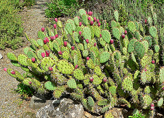
Opuntia engelmannii is a prickly pear common across the south-central and Southwestern United States and northern Mexico. It goes by a variety of common names, including desert prickly pear, discus prickly pear, Engelmann's prickly pear in the US, and nopal, abrojo, joconostle, and vela de coyote in Mexico.

Eustatia Island is a 30-acre island of the British Virgin Islands (BVI) in the Caribbean. The word "Eustatia" is a Greek derived word meaning, "good place to stay." The entire island, and a small neighboring island, Saba Rock, are under the same long term lease. The island is regularly featured and photographed for several publications and was listed as one of the top 20 most beautiful islands in the world in the December 2004 issue of Islands magazine.

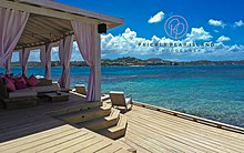
Prickly Pear is an uninhabited island of the British Virgin Islands in the Caribbean. Even though the island doesn't have permanent residents, it has a beach bar and recreational water sports facility on it. It is located on the north side of North Sound, opposite Virgin Gorda.
Bethesda is a township in Saint Paul Parish on the island of Antigua, in Antigua and Barbuda.

Opuntia humifusa, commonly known as the devil's-tongue, Eastern prickly pear or Indian fig, is a cactus of the genus Opuntia present in parts of the eastern United States, Mississippi and northeastern Mexico.

Antigua and Barbuda lie in the eastern arc of the Leeward Islands of the Lesser Antilles, separating the Atlantic Ocean from the Caribbean Sea. Antigua is 650 km (400 mi) southeast of Puerto Rico; Barbuda lies 48 km (30 mi) due north of Antigua, and the uninhabited island of Redonda is 56 km (35 mi) southwest of Antigua.
Opuntia, commonly called prickly pear or pear cactus, is a genus of flowering plants in the cactus family Cactaceae. Prickly pears are also known as tuna (fruit), sabra, nopal from the Nahuatl word nōpalli for the pads, or nostle, from the Nahuatl word nōchtli for the fruit; or paddle cactus. The genus is named for the Ancient Greek city of Opus, where, according to Theophrastus, an edible plant grew and could be propagated by rooting its leaves. The most common culinary species is the Indian fig opuntia (O. ficus-indica).

Morne Rachette or Morne Raquette is a village on the west coast of Dominica, in the northwest corner of Saint Joseph Parish. It is located on the slopes of Morne Jalousie, above Coulibistrie to its immediate north and Batalie Bay. The village of Salisbury is south of Morne Rachette.

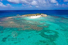
The Prickly Pear Cays, sometimes spelt as Prickley Pear Cays, are a small pair of uninhabited islands about six miles from Road Bay, Anguilla, in the Leeward Islands of the Caribbean. They are divided by a narrow boat channel between Prickly Pear East and Prickly Pear West. Prickly Pear Cays were classified as 'wildlands' by the "Eastern Caribbean Natural Area Management Programme" (ECNAMP). In addition, Prickly Pear Cays are one of six marine protected areas of Anguilla.
Springdale is a rural locality in the Southern Downs Region, Queensland, Australia. In the 2016 census, Springdale had a population of 25 people.