
Boise Airport is a joint civil-military airport in the western United States in Idaho, three miles (5 km) south of downtown Boise in Ada County. The airport is operated by the city of Boise Department of Aviation, overseen by an airport commission. The busiest airport in the state, it serves more passengers than all other Idaho airports combined and roughly ten times as many passengers as the next busiest airport at Idaho Falls.

Yellowstone Airport is a state-owned public-use airport located adjacent to U.S. 191/U.S. 287 one nautical mile (2 km) north of the central business district of West Yellowstone, a town in Gallatin County, Montana, United States. Although only open from June through September, commercial passenger service is available during those months. Scheduled airline service is subsidized by the federal Essential Air Service (EAS) program.

Ralph Wien Memorial Airport is a state-owned public-use airport located on the south side of Kotzebue, a city on the Baldwin Peninsula in the Northwest Arctic Borough of the U.S. state of Alaska.
Lake Billy Chinook Airport, also known as Lake Billy Chinook State Airport, is a public use airport located six nautical miles west of the central business district of Culver, a city in Jefferson County, Oregon, United States. The airport is privately owned, despite the name which might give the impression that it was owned by the state.
Tanglefoot Seaplane Base is a privately owned, public-use seaplane base in Bonner County, Idaho, United States. It is located at Priest Lake, on west shore of Cavanaugh Bay.
Cavanaugh Bay Airport is a public use airport located three nautical miles (6 km) north of the central business district of Coolin, in Bonner County, Idaho, United States. It is owned by the State of Idaho, Idaho Transportation Department, Division of Aeronautics. The airport is located on the east side of Priest Lake, at the south end of Cavanaugh Bay.
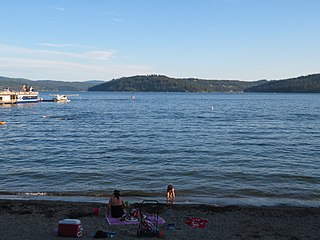
Brooks Seaplane Base is a city-owned, public-use seaplane base located in the city of Coeur d'Alene, Kootenai County, Idaho, United States. It is located on Lake Coeur d'Alene.
Tower Municipal Airport is a city-owned public-use airport located one nautical mile (2 km) northwest of the central business district of Tower, a city in Saint Louis County, Minnesota, United States. It is located on Lake Vermilion and is also known as Tower Municipal Airport & Seaplane Base.
Condon USFS Airport is a public use airport located one nautical mile northwest of the central business district of Condon, in Missoula County, Montana, United States. It is owned by the United States Forest Service (USFS).
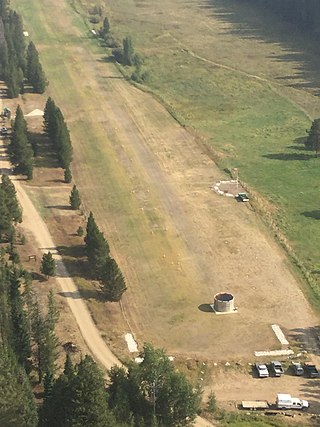
Indian Creek USFS Airport is a public use airport located at Indian Creek in Valley County, Idaho, United States. It is owned by the U.S. Forest Service. The airstrip is situated next to the Middle Fork Salmon River.
Aberdeen Municipal Airport is a city-owned public-use airport located two nautical miles southwest of the central business district of Aberdeen, a city in Bingham County, Idaho, United States. According to the FAA's National Plan of Integrated Airport Systems for 2009–2013, it is categorized as a general aviation facility.
Alsek River Airport is a public-use airport located 44 nautical miles (81 km) southeast of the central business district of Yakutat, a city and borough in the U.S. state of Alaska. It is owned by the USFS Tongass National Forest. As per Federal Aviation Administration records, the airport had 507 passenger boardings (enplanements) in calendar year 2008.

Chamberlain USFS Airport is a public use airport located at Chamberlain Guard Station, in Idaho County, Idaho, United States. The airport is owned by the U.S. Forest Service. It is located near Chamberlain Creek in the Payette National Forest.
Cabin Creek USFS Airport is a public-use airport in Valley County, Idaho, United States. It is located 17 nautical miles east of Big Creek Ranger Station. The airport is owned by the U.S. Forest Service. The airstrip is near Cabin Creek in the Payette National Forest.
Big Creek Airport is a state-owned public-use airstrip in Valley County, Idaho, United States. It is located 12 nautical miles northeast of Yellow Pine, Idaho and 17 nautical miles west of the Cabin Creek USFS Airport . The airstrip is actually on Forest Service managed land. The state of Idaho Division of Aeronautics has a special use permit to perform annual maintenance on the strip and some facilities. The airport is located at the Big Creek Ranger Station in Payette National Forest, adjacent to the Big Creek Campground. The airstrip serves the Big Creek Lodge.
Dixie USFS Airport is a public-use U.S. Forest Service airport located three nautical miles southwest of the central business district of Dixie, in Idaho County, Idaho, United States.
Wilson Bar USFS Airport is a public-use U.S. Forest Service airport located eight nautical miles south of the central business district of Dixie, in Idaho County, Idaho, United States. It is owned by the Nez Perce National Forest.
Orogrande Airport is a public-use airport located one nautical mile northeast of the central business district of Orogrande, in Idaho County, Idaho, United States. It is owned by the U.S. Forest Service.
Reed Ranch Airport is a public use airport located 12 nautical miles southwest of the central business district of Yellow Pine, in Valley County, Idaho, United States. It is owned by the Idaho Division of Aeronautics / USFS.
Bear Lake County Airport is a county-owned, public-use airport in Bear Lake County, Idaho, United States. It is located three nautical miles (6 km) east of the central business district of Paris, Idaho. This airport is included in the National Plan of Integrated Airport Systems for 2011–2015, which categorized it as a general aviation facility.
