
Kennington is a district in south London, England. It is mainly within the London Borough of Lambeth, running along the boundary with the London Borough of Southwark, a boundary which can be discerned from the early medieval period between the Lambeth and St George's parishes of those boroughs respectively. It is located 1.4 miles (2.3 km) south of Charing Cross in Inner London and is identified as a local centre in the London Plan. It was a royal manor in the parish of St Mary, Lambeth in the county of Surrey and was the administrative centre of the parish from 1853. Proximity to central London was key to the development of the area as a residential suburb and it was incorporated into the metropolitan area of London in 1855.

Stockwell is a district in South West London, England, located in the London Borough of Lambeth. It is situated 2.4 miles (3.9 km) south of Charing Cross. Battersea, Brixton, Clapham, South Lambeth, Oval and Kennington all border Stockwell.

Vauxhall is a district of South London, England. Vauxhall was part of Surrey until 1889 when the County of London was created. Named after a medieval manor "Fox Hall", it became well known for the Vauxhall Pleasure Gardens.

Lambeth is a London borough in South London, England, which forms part of Inner London. Its name was recorded in 1062 as Lambehitha and in 1255 as Lambeth. The geographical centre of London is at Frazier Street near Lambeth North tube station, though nearby Charing Cross on the other side of the Thames in the City of Westminster is traditionally considered the centre of London.

Lambeth is a district in South London, England, in the London Borough of Lambeth, historically in the County of Surrey. It is situated 1 mile (1.6 km) south of Charing Cross. The population of the London Borough of Lambeth was 303,086 in 2011. The area experienced some slight growth in the medieval period as part of the manor of Lambeth Palace. By the Victorian era the area had seen significant development as London expanded, with dense industrial, commercial and residential buildings located adjacent to one another. The changes brought by World War II altered much of the fabric of Lambeth. Subsequent development in the late 20th and early 21st centuries has seen an increase in the number of high-rise buildings. The area is home to the International Maritime Organization.

Lambeth was a civil parish and metropolitan borough in south London, England. It was an ancient parish in the county of Surrey. The parish was included in the area of responsibility of the Metropolitan Board of Works in 1855 and became part of the County of London in 1889. The parish of Lambeth became a metropolitan borough in 1900, following the London Government Act 1899, with the parish vestry replaced by a borough council.
Oval is an area in south London, in the London Borough of Lambeth. It is part of Kennington near The Oval cricket ground, situated 2.1 miles (3.38 km) to the south-east of Charing Cross. Oval straddles the border of south-west London and south-east London, and is where the postcode SE11 converges with the postcodes SW8 and SW9.
Streatham is a constituency represented in the House of Commons of the UK Parliament since 2019 by Bell Ribeiro-Addy of the Labour Party.
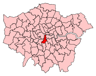
Vauxhall is a constituency represented in the House of Commons by Florence Eshalomi of Labour Co-op since her election in 2019.

Lambeth Walk is a street in Lambeth, London, England, off Lambeth Road. It was at the heart of a working-class residential area and there was a street market.
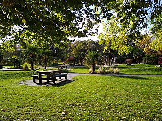
The London Borough of Lambeth, in spite of being close to the centre of London has over 64 areas of parks and open spaces, in addition to 34 play areas and eight paddling pools, within its boundaries. In common with all the London boroughs these green spaces provide "lungs" for the leisure pursuits of the inhabitants.

Kennington Road is a long straight road, approximately a mile in length, in the London Borough of Lambeth in London, England, running south from Westminster Bridge Road to Kennington Park Road.

Kennington Park Road is a main road in south-east London, England, and is part of the A3 trunk road. It runs from Newington Butts at its Y-junction with Kennington Lane, south-west to the Oval, where the A3 continues as Clapham Road, towards Stockwell. At this crossroads junction, Camberwell New Road and Kennington Oval head towards Camberwell Green and Vauxhall respectively.

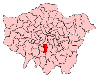
Lambeth North was a borough constituency centred on the Lambeth district of South London. It returned one Member of Parliament (MP) to the House of Commons of the Parliament of the United Kingdom, elected by the first past the post system.

The A202 is a primary A road in London. It runs from New Cross Gate to London Victoria station. A section of the route forms a part of the London Inner Ring Road between Vauxhall and Victoria, known as Vauxhall Bridge Road.
Larkhall is a ward in the London Borough of Lambeth, represented locally by Labour councillors Andy Wilson, Tina Valcarcel and Tim Windle. Prior to her entry to Parliament, it was represented by Marsha de Cordova MP. It is one of eight wards in the Vauxhall constituency represented at national level by Florence Eshalomi MP.

Vassall ward is an administrative division of the London Borough of Lambeth, United Kingdom. It is also known as 'Myatt's Field' when informally describing the area. It is located in the North of borough bordering Southwark, in the SW9 and SE5 postcode area. The area is named after Henry Vassall-Fox, 3rd Baron Holland who was responsible for the first building development in the area in the 1820s.
Myatt's Fields South is a social housing estate located between Brixton Road and Camberwell New Road in South London. It is on land that once formed part of the Lambeth Wick estate.
This is a list of the toponymy of street names in the London district of Vauxhall. The area has no formally defined boundaries – those utilised here are Black Prince Road to the north, Kennington Road to the north-east, Kennington Park Road/Clapham Road to the south-east, Miles Street/Fentiman Road to the south, and Wandsworth Road/Nine Elms Lane/river Thames to the west.

Cleaver Square is an 18th-century garden square in the London Borough of Lambeth, dating from 1789. It is notable for having been the first garden square in South London.