Related Research Articles
Millinocket Municipal Airport is a town-owned, public-use airport located one nautical mile (2 km) southeast of the central business district of Millinocket, a town in Penobscot County, Maine, United States. It once offered commercial airline service on Northeast Airlines.
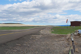
Enterprise Municipal Airport is a city-owned, public-use airport located in Enterprise, a city in Wallowa County, Oregon, United States.
Elkhart Municipal Airport is a city-owned public-use airport located three nautical miles (6 km) northwest of the central business district of Elkhart, a city in Elkhart County, Indiana, United States.
Fernandina Beach Municipal Airport is a city-owned public-use airport located on Amelia Island three nautical miles (6 km) south of the central business district of Fernandina Beach, a city in Nassau County, Florida, United States. It is designated as a reliever airport for Jacksonville International Airport.
Ralph M. Sharpe Airport is a privately owned, public use airport in Tunica County, Mississippi, United States. It is located two nautical miles (4 km) south of the central business district of Tunica, Mississippi.

Lanett Municipal Airport is a city-owned public-use airport located three nautical miles southwest of the central business district of Lanett, a city in Chambers County, Alabama, United States. According to the FAA's National Plan of Integrated Airport Systems for 2009–2013, it is categorized as a general aviation facility.
Old Town Municipal Airport and Seaplane Base, also known as Dewitt Field, is a public use airport located two nautical miles (4 km) northwest of the central business district of Old Town, in Penobscot County, Maine, United States. It is owned by the City of Old Town. The seaplane base is located on Marsh Island on the Penobscot River.
French Lick Municipal Airport is a city-owned public-use airport located three nautical miles southwest of the central business district of French Lick, a town in Orange County, Indiana, United States. Also known as French Lick Airport, it serves the French Lick and West Baden, Indiana area.
Belfast Municipal Airport is a public use airport in Waldo County, Maine, United States. It is owned by the City of Belfast and is located one nautical mile southwest of its central business district.
Eastport Municipal Airport is a city-owned public-use airport located one nautical mile west of the central business district of Eastport, a city in Washington County, Maine, United States.
Central Maine Airport of Norridgewock is a public use airport in Somerset County, Maine, United States. It is owned by the Town of Norridgewock and is located four nautical miles west of the central business district.
Biddeford Municipal Airport is a public use airport in York County, Maine, United States. It is owned by the City of Biddeford and is located two nautical miles south of the central business district.

Princeton Municipal Airport is a city-owned public-use airport located one nautical mile southwest of the central business district of Princeton, a city in Mille Lacs County, Minnesota, United States. This airport is included in the FAA's National Plan of Integrated Airport Systems 2015–2019, which categorizes it as a general aviation airport.

Deblois Flight Strip is a public-use airport located two nautical miles southeast of the central business district of Deblois, a town in Washington County, Maine, United States. It is currently owned by the Maine Department of Transportation, and managed by Randy Gray, Superintendent of Operations for the Eastern Region.
Bowman Field is a privately owned public-use airport located four nautical miles southeast of the central business district of Livermore Falls, a town in Androscoggin County, Maine, United States.
Pine Hill Municipal Airport was a town-owned public-use airport located one nautical mile south of the central business district of Pine Hill, a town in Wilcox County, Alabama, United States.
Cutler Regional Airport is a public use airport located two nautical miles (4 km) west of the central business district of Cutler, a town in Washington County, Maine, United States.
Stephen A. Bean Municipal Airport is a town owned, public use airport located two nautical miles (4 km) northwest of the central business district of Rangeley, a town in Franklin County, Maine, United States. It is included in the National Plan of Integrated Airport Systems for 2011–2015, which categorized it as a general aviation facility.
Pittsfield Municipal Airport is a town owned, public use airport located one nautical mile (2 km) southeast of the central business district of Pittsfield, a town in Somerset County, Maine, United States. It is included in the National Plan of Integrated Airport Systems for 2011–2015, which categorized it as a general aviation facility.
Gillespie Field is a public use airport located one nautical mile (2 km) west of the central business district of Meddybemps, a town in Washington County, Maine, United States.