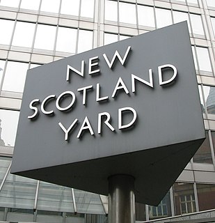
Scotland Yard is a metonym for the headquarters building of the Metropolitan Police, the territorial police force responsible for policing all 32 boroughs of London, excluding the City of London.
Smith Square is a square in Westminster, London, 250 metres south-southwest of the Palace of Westminster. Most of its garden interior is filled by St John's, Smith Square, a Baroque surplus church, which has inside converted to a concert hall. Most adjoining buildings are offices, with the focus on organisations lobbying or serving the government. In the mid-20th century, the square hosted the headquarters of the two largest parties of British politics, and it is now hosts much of the Department for Environment, Food and Rural Affairs and the Local Government Association. It has a pedestrian or mixed approach to the four sides and another approach to the north.

Threadneedle Street is a street in the City of London, England between Bishopsgate at its northeast end and Bank junction in the southwest. It is one of nine streets that converge at Bank. It lies in the ward of Cornhill.

Tavistock Square is a public square in Bloomsbury, in the London Borough of Camden.

The WC postcode area, also known as the London WC postcode area, is a group of postcode districts in central London, England. The area covered is of high density development, and includes parts of the City of Westminster and the London Boroughs of Camden and Islington, plus a very small part of the City of London.

Pontypridd is a constituency represented in the House of Commons of the UK Parliament since 2019 by Alex Davies-Jones of the Labour Party.

The Marx Memorial Library in London holds more than 43,000 books, pamphlets and newspapers on Marxism, Scientific Socialism and working class history. It is a Grade II listed building.
Norfolk House, 31 St James's Square, Westminster, was built between 1748 and 1752 as his London townhouse by Edward Howard, 9th Duke of Norfolk (1686–1777) to the design of Matthew Brettingham (1699–1769), "the Elder", and was demolished in 1938. His country house and main seat was Worksop Manor in Nottinghamshire. Norfolk House was built on a site formerly occupied by two houses, namely St Albans House, the residence of the Earl of St. Albans the other the residence of John Belasyse, 1st Baron Belasyse (1614–1689). Both these houses were demolished in 1748 by the 9th Duke of Norfolk in preparation for his new house.

Cardinal Place is a retail and office development in London, near Victoria Station and opposite Westminster Cathedral. The site consists of three buildings covering over a million square feet on Victoria Street next door to Portland House, and was designed by EPR Architects and built by Sir Robert McAlpine.

Torrington Square is a square in Bloomsbury, owned by the University of London, located in central London, England. Today it is a square in name only, most of the houses having been demolished by the university. The southern end of the square is dominated by the University of London's Senate House. Birkbeck College and the School of Oriental and African Studies (SOAS) are located here. To the southwest is Malet Street and to the southeast is Russell Square. The square is the site of a weekly farmers' market, held on Thursdays.

Southampton Row is a major thoroughfare running northwest–southeast in Bloomsbury, Camden, central London, England. The road is designated as part of the A4200.

St George Botolph Lane was a church off Eastcheap, in the ward of Billingsgate in the City of London. The rear of the church overlooked Pudding Lane, where the fire of London started. It was first recorded in the twelfth century, and destroyed in the Great Fire of 1666. It was one of the 51 churches rebuilt by the office of Sir Christopher Wren. The church was demolished in 1904.

The Faraday Building is in the south-west of the City of London. It reaches double its normal number of storeys, ten above ground, as to three modest western rectangular turrets which are prominent in its streetscape – topping a c-shaped, three-storey belvedere (superstructure) that has a verdigris hipped roof. It was the GPO's first telephone exchange in London, and is still used by BT Group. It fronts Queen Victoria Street and backs onto Knightrider Street. The block is one narrow block east from Peters Hill which is the northern footpath to/from the Millennium Bridge.

Macdonald House was a seven-storey Neo-Georgian style building on Grosvenor Square in Mayfair, London. It was part of the High Commission of Canada from 1961 to 2014. Macdonald House was used for the High Commission's cultural and consular functions, trade and administrative sections, immigration section, and as the High Commissioner's official residence. From 1938 to 1960, the building was the Embassy of the United States.

Spring Gardens is a dead-end street at the south east extreme of St. James's, London, England, that crosses the east end of The Mall between Admiralty Arch and Trafalgar Square. Part of the old liberty of Westminster and the current City of Westminster, it abuts Whitehall, Horse Guards Parade, Green Park, and the Charing Cross/Strand/Trafalgar Square locality.

St Mary Mounthaw or Mounthaut was a parish church in Old Fish Street Hill in the City of London. Of medieval origin, it was destroyed in the Great Fire of London in 1666 and not rebuilt.

Finsbury Square is a 0.7-hectare (1.7-acre) square in Finsbury in central London which includes a six-rink grass bowling green. It was developed in 1777 on the site of a previous area of green space to the north of the City of London known as Finsbury Fields, in the parish of St Luke's and near Moorfields. It is sited on the east side of City Road, opposite the east side of Bunhill Fields. It is approximately 200m north of Moorgate station, 300m north-west of Liverpool Street station and 400m south of Old Street station. Nearby locations are Finsbury Circus and Finsbury Pavement. Named after it, but several miles away, are Finsbury Park and its eponymous neighbourhood.

The Embassy of Colombia in London is the diplomatic mission of the Republic of Colombia in the United Kingdom. It is headed by the Ambassador of Colombia to the United Kingdom. It is located in the Knightsbridge district in a building it shares with the Embassy of Ecuador, near Harrods, Hyde Park, and Hans Place, precisely at 3 Hans Crescent at the intersection of Basil Street, and it is serviced by the Knightsbridge station.
Bracken House is a building at 1 Friday Street and 10 Cannon Street in the City of London, occupied by the Financial Times newspaper until the 1980s, and again beginning May 2019. A late example of modern classicism, it was constructed from 1955 to 1958 to a design by Sir Albert Richardson to serve as the headquarters and printing works of the Financial Times, on a cleared bomb site southeast of St Paul's Cathedral.

Salisbury Square is a square in London EC4.

