Italian colonial era
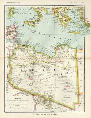
After Italy took the area from the Ottoman Empire in 1912, it was administered as a single administrative unit, called Italian North Africa. Then, from 1927 to 1934, the territory was split into two separate colonies, each of which run by its own Italian governor: Italian Cyrenaica and Italian Tripolitania. In 1934, Italy adopted the name "Libya" (Italian Libya) as the official name of the reunified area and administratively divided it up into the three provinces of Cyrenaica, Tripolitania and Fezzan. In 1937, the Cyrenaica and Tripolitania provinces split, with northern Cyrenaica becoming Benghazi Province and Darnah Province and northern Tripolitania splitting into Tripoli Province and Misurata Province. [1]
Fezzan was not split in 1937, but the whole southern Sahara Desert area was militarily administered as the Southern Military Territory (Territorio del Sahara Libico or Il Territorio Militare del Sud Libico). [2]
The Libyan Sahara Territory was divided into four military districts administered from the desert oases towns of Ghat, Brak, Murzuk and Hun. The Senussi order Kufra oasis area in the southeastern Libyan Desert was not separately administered by the Italians, but in 1932, they built a fort at the holy place of El Tag above it. This territory was administered only by the Italian military and in 1936 was increased with the inclusion of Aouzou Strip from France's Chad. [3]

Libya is the fourth largest country in Africa and the sixteenth largest country in the world. It is on the Mediterranean with Egypt to the east, Tunisia to the northwest, Algeria to the west, Niger and Chad to the south, and Sudan to the southeast. Although the oil discoveries of the 1960s have brought immense wealth, at the time of its independence it was an extremely poor desert state whose only important physical asset appeared to be its strategic location at the midpoint of Africa's northern rim.

Cyrenaica or Kyrenaika, is the eastern region of Libya. Cyrenaica includes all of the eastern part of Libya between the 16th and 25th meridians east, including the Kufra District. The coastal region, also known as Pentapolis in antiquity, was part of the Roman province of Crete and Cyrenaica, later divided into Libya Pentapolis and Libya Sicca. During the Islamic period, the area came to be known as Barqa, after the city of Barca.

In Libya there are currently 106 districts, second level administrative subdivisions known in Arabic as baladiyat. The number has varied since 2013 between 99 and 108. The first level administrative divisions in Libya are currently the governorates (muhafazat), which have yet to be formally delineated, but which were originally tripartite as: Tripolitania in the northwest, Cyrenaica in the east, and Fezzan in the southwest; and later divided into ten governorates.

Fezzan is the southwestern region of modern Libya. It is largely desert, but broken by mountains, uplands, and dry river valleys (wadis) in the north, where oases enable ancient towns and villages to survive deep in the otherwise inhospitable Sahara Desert. The term originally applied to the land beyond the coastal strip of Africa proconsularis, including the Nafusa and extending west of modern Libya over Ouargla and Illizi. As these Berber areas came to be associated with the regions of Tripoli, Cirta or Algiers, the name was increasingly applied to the arid areas south of Tripolitania.

Tripolitania, historically known as the Tripoli region, is a historic region and former province of Libya.
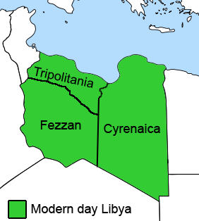
Subdivisions of Libya have varied significantly over the last two centuries. Initially Libya under Ottoman and Italian control was organized into three to four provinces, then into three governorates (muhafazah) and after World War II into twenty-five districts (baladiyah). Successively into thirty-two districts (shabiyat) with three administrative regions, and then into twenty-two districts (shabiyat). In 2012 the ruling General National Congress divided the country into governorates (muhafazat) and districts (baladiyat). While the districts have been created, the governorates have not.

The Italian colonizationof Libya began in 1911 and it lasted until 1943. The country, which was previously an Ottoman possession, was occupied by Italy in 1911 after the Italo-Turkish War, which resulted in the establishment of two colonies: Italian Tripolitania and Italian Cyrenaica. In 1934, the two colonies were merged into one colony which was named the colony of Italian Libya. In 1937, this colony was divided into four provinces, and in 1939, the coastal provinces became a part of metropolitan Italy as the Fourth Shore. The colonization lasted until Libya's occupation by Allied forces in 1943, but it was not until the 1947 Paris Peace Treaty that Italy officially renounced all of its claims to Libya's territory.
Hun or Houn is an oasis town in the northern Fezzan region of southwest Libya. The town is the capital of the Jufra District. The "International Autumn Tourism Festival" is an annual festival usually held at the end of September.

Libya was a colony of Fascist Italy located in North Africa, in what is now modern Libya, between 1934 and 1943. It was formed from the unification of the colonies of Cyrenaica and Tripolitania, which had been Italian possessions since 1911.
Italian Tripolitania was an Italian colony, located in present-day western Libya, that existed from 1911 to 1934. It was part of the territory conquered from the Ottoman Empire after the Italo-Turkish War in 1911. Italian Tripolitania included the western northern half of Libya, with Tripoli as its main city. In 1934, it was unified with Italian Cyrenaica in the colony of Italian Libya. In 1939, Tripolitania was considered a part of the Kingdom of Italy's 4th Shore.

Al-Khums or Khoms is a city, port and the de jure capital of the Murqub District on the Mediterranean coast of Libya with an estimated population of around 202,000. The population at the 1984 census was 38,174. Between 1983 and 1995 it was the administrative center of al-Khums District.
This is a survey of the postage stamps and postal history of Cyrenaica, now part of Libya.

This is a survey of the postage stamps and postal history of Libya. Libya is a country located in North Africa. Bordering the Mediterranean Sea to the north, Libya lies between Egypt to the east, Sudan to the southeast, Chad and Niger to the south, and Algeria and Tunisia to the west.
Benghazi Province, or Provincia di Bengasi in Italian, was one of the provinces of Libya under Italian rule. It was established in 1937.

The Allied administration of Libya was the control of the ex-colony of Italian Libya by the Allies from 13 May 1943 until Libyan independence was granted in 1951. It was divided into two parts:

The British Military Administration of Libya was the control of the regions of Cyrenaica and Tripolitania of the former Italian Libya by the British from 1943 until Libyan independence in 1951. It was part of the Allied administration of Libya.
The Southern Military Territory was a jurisdictional territory within the Italian colonies of Cyrenaica and Tripolitania (1911-1934) and later Italian Libya (1934–1947), administered by the Italian military in the Libyan Sahara.
The Fezzan-Ghadames Military Territory was a territory in the southern part of Italian Libya which was occupied and administered by Free France from 1943 until Libya gained independence in 1951. It was part of the allied occupation of Libya.
Tripolitania province is one of the three traditional Provinces of Libya. It was a formal province from 1934 until 1963, when it was subdivided into the Governorates of Libya. Its capital was the city of Tripoli. Between 1911 and 1934 it had been the separately governed colony of Italian Tripolitania.
Fezzan province is one of the three traditional Provinces of Libya. It was a formal province from 1934 until 1963, when it was subdivided into the Governorates of Libya. Its capital was the city of Sabha.
