Tripoli or Tripolis may refer to:

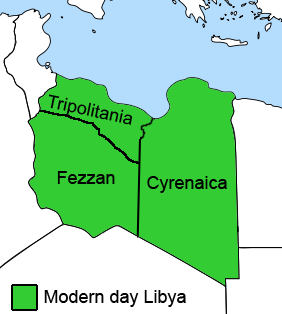
In Libya there are currently 106 districts, second level administrative subdivisions known in Arabic as baladiyat. The number has varied since 2013 between 99 and 108. The first level administrative divisions in Libya are currently the governorates (muhafazat), which have yet to be formally deliniated, but which were originally tripartite as: Tripolitania in the northwest, Cyrenaica in the east, and Fezzan in the southwest; and later divided into ten governorates.

Nuqat al Khams is one of the districts of Libya. It is in the northwest of the country, in what had been the historical region of Tripolitania. Its capital is Zuwara. Nuqat al Khams has a northern shoreline on the Mediterranean Sea. To the west, it borders the Medenine Governorate of Tunisia. Domestically, it borders the districts of Zawiya to the east, Jabal al Gharbi to the southeast, and Nalut to the southwest. Nuqat al Khams is a part of the Tripolitania geographical region of Libya.

Zawiya, officially Zawia, is one of the districts of Libya. It is located in the north western part of the country, in what had been the historical region of Tripolitania. Its capital is also named Zawia. the province of Az Zawiya has three major municipalities; according to the new laws of local governance, includes Central Az Zawiya municipality, Southern Az Zawia municipality and Eastern Az zawiya municipality. In the north, Zawiya province has a shoreline bordering the Mediterranean Sea, while it borders Tripoli in east, Jafara in southeast, Jabal al Gharbi in south, Surman in the west.

Misrata or Misratah, also known by the Italian spelling Misurata, is a city in the Misrata District in northwestern Libya, situated 187 km (116 mi) to the east of Tripoli and 825 km (513 mi) west of Benghazi on the Mediterranean coast near Cape Misrata. With a population of about 881,000, it is the third-largest city in Libya, after Tripoli and Benghazi. It is the capital city of the Misrata District and has been called the trade capital of Libya. The harbor is at Qasr Ahmad.

Tripolitania, historically known as the Tripoli region, is a historic region and former province of Libya.

Butnan sometimes called Tubruq District or Tobruk District from the former name, occasionally Marmarica, is an administrative district (shabiyah) in eastern Libya. Its capital city is Tobruk.

Murqub, sometimes spelt Al Murgub or Al Marqab or al-Morqib, is one of the districts of Libya. The main city and capital is Khoms. The widely visited UNESCO World Heritage Site of Leptis Magna is also located in the district. In the north, Murqub has a shoreline on the Mediterranean Sea. On land, it borders Misrata to the east and south, Tripoli to the northwest and Jabal al Gharbi to the west.
The governorates of Libya (muhafazah) were a tenfold top-level administrative division of Libya from 1963 until 1983.
Subdivisions of Libya have varied significantly over the last two centuries. Initially Libya under Ottoman and Italian control was organized into three to four provinces, then into three governorates (muhafazah) and after World War II into twenty-five districts (baladiyah). Successively into thirty-two districts (shabiyat) with three administrative regions, and then into twenty-two districts (shabiyat). In 2012 the ruling General National Congress divided the country into governorates (muhafazat) and districts (baladiyat). While the districts have been created, the governorates have not.

The Provinces of Libya were prescribed in 1934, during the last period of colonial Italian Libya, and continued through post-independence Libya until 1963 when the Governorates system was instituted.

The Italian colonizationof Libya began in 1911 and it lasted until 1943. The country, which was previously an Ottoman possession, was occupied by Italy in 1911 after the Italo-Turkish War, which resulted in the establishment of two colonies: Italian Tripolitania and Italian Cyrenaica. In 1934, the two colonies were merged into one colony which was named the colony of Italian Libya. In 1937, this colony was divided into four provinces, and in 1939, the coastal provinces became a part of metropolitan Italy. The colonization lasted until Libya's occupation by Allied forces in 1943, but it was not until the 1947 Paris Peace Treaty that Italy officially renounced all of its claims to Libya's territory.

Al Wahat or The Oases, occasionally spelt Al Wahad or Al Wahah is one of the districts of Libya. Its capital and largest city is Ajdabiya. The district is home to much of Libya's petroleum extraction economic activity.

Italian Tripolitania was an Italian colony, located in present-day western Libya, that existed from 1911 to 1934. It was part of the territory conquered from the Ottoman Empire after the Italo-Turkish War in 1911. Italian Tripolitania included the western northern half of Libya, with Tripoli as its main city. In 1934, it was unified with Italian Cyrenaica in the colony of Italian Libya. In 1939, Tripolitania was considered a part of the Kingdom of Italy's 4th Shore.
Bin Jawad District, was one of the districts (baladiyah) of Libya from 1983 to 1987. It lay in the northern part of the country bordering the Gulf of Sidra. Its capital was Bin Jawad. Under Italy it was in Misrata Province. Before being made a baladiyah in 1983, it was part of the governorate system. In 1987 the area was incorporated into Sirte District and has remained there since.

Al-Khums or Khoms is a city, port and the de jure capital of the Murqub District on the Mediterranean coast of Libya with an estimated population of around 202,000. The population at the 1984 census was 38,174. Between 1983 and 1995 it was the administrative center of al-Khums District.

Jabal al Gharbi or The Western Mountain is one of the districts of Libya. It is named after the Nafusa Mountains. It was formed in 2007 from the former districts of Yafran, Gharyan and Mizda. From 1995 to 1998 Jabal al Gharbi also existed as a Baladiyah. Jabal al Gharbi borders Sirte and Misrata to the east, Murqub to the northeast, Jafara and Zawiya to the north, Nuqat al Khams to the northwest, Nalut to the west, Tripoli to the north, Wadi al Shatii to the south and Jufra to the southeast.

Misrata Governorate was one of the governorates (muhafazah) of Libya from 1963 to 1983. Its capital was the town of Misrata. Initially in the 1930s was called "Provincia di Misurata" of Italian Libya. It was created out of the eastern part of Tripolitania province.
Cyrenaica province is one of the three traditional Provinces of Libya. It was a formal province from 1934 until 1963, when it was subdivided into the Governorates of Libya. Its capital was the city of Benghazi. Between 1911 and 1934 it had been the separately governed colony of Italian Cyrenaica.
Fezzan province is one of the three traditional Provinces of Libya. It was a formal province from 1934 until 1963, when it was subdivided into the Governorates of Libya. Its capital was the city of Sabha.
