Subdivisions of Libya

Last updated
The 3 main historical subdivisions of Libya Ottoman Provinces Of Present day Libyapng.png
The 3 main historical subdivisions of Libya

Subdivisions of Libya have varied significantly over the last two centuries. Initially Libya under Ottoman and Italian control was organized into three to four provinces, then into three governorates ( muhafazah ) and after World War II into twenty-five districts ( baladiyah ). Successively into thirty-two districts ( shabiyat ) with three administrative regions, and then into twenty-two districts (shabiyat). In 2012 the ruling General National Congress divided the country into governorates (muhafazat) and districts (baladiyat). [1] [2] While the districts have been created, [3] the governorates have not. [4] [5]

Contents

History

Prior to the Italian invasion of 1911, the area of Libya was administered as three separate provinces ("Vilayets") of the Ottoman Empire: Tripolitania, Fezzan, and Cyrenaica.

At first, Italy continued the tripartite administration, but soon consolidated the area into a single province/gobernatorate administered as the "Libyan Colony". Indeed, until about 1931 -when the last of the native resistance to the Italians was subdued- the area was divided into three historical regions (Tripolitania, Cyrenaica and Fezzan/"Territorio Sahara").

Then, in 1937, Italian governor Italo Balbo created the political entity called Libya. His Italian Libya was re-divided into four provinces and one territory: Tripoli, Misurata, Benghazi, Derna, (in the coastal north) and the "Southern Military Territory" (Italian : Territorio Militare del Sud) (in the Saharan south). [6]

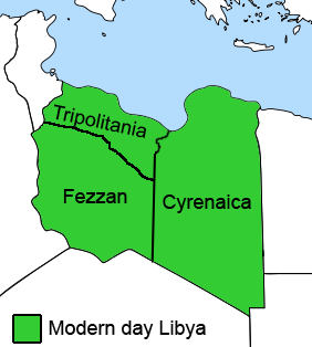
After the French and British occupied Libya in 1943, it was again split into three provinces: Tripolitania in the northwest, Cyrenaica in the east, and Fezzan-Ghadames in the southwest. [7]

After independence, Libya was divided into three governorates ( muhafazat ), matching the three provinces of before, but in 1963 it was divided into ten governorates.

Provinces

The Provinces of Libya existed during the last period of colonial Italian Libya through post-independence Libya. The country was divided into provinces from 1934 in the colonial era to 1963 when the Governorates system was instituted.

Governorates

The Governorates of Libya (muhafazah) were an administrative division of Libya from 1963 until 1983. Initially there were 46 governorates-districts, called baladiyah, that were reduced to 25 in 1987.

Libyan governorates-districts ("Baladiyah") in 1987 Libia regions with numbers.svg
Libyan governorates-districts ("Baladiyah") in 1987
بلديةBaladiyahMain cityPopulation
(in 1984)
Number
(on the map)
طبرق Butnan Tobruk 94,0063
درنة Darnah Derna 105,03114
الجبل الاخضر Jabal al Akhdar Bayda 120,6625
المرج Marj Marj 102,7634
بنغازي Benghazi Benghazi 485,38613
إجدابيا Al Wahat Ajdabiya 100,5471
الكفرة Kufra Al Jawf 25,1398
سرت Sirte Sirte 110,99621
مصراتة Misratah Misrata 178,29517
Khoms Khoms 149,6427
طرابلس Tripoli (Tarabulus) Tripoli 990,69722
العزيزيه Al 'Aziziyah 'Aziziya 85,0682
الزاوية Az Zawiyah Zawiya 220,07512
النقاط الخمس Nuqat al Khams Zuwara 181,5849
الجبل الغربي Gharyan Gharyan 117,07316
Zlitan Zliten 101,10725
الجفرة Al Jufrah Waddan  ?6
الشاطئ Ash Shati' Brak 46,74910
سبها Sabha Sabha 76,17119
أوباري Awbari Ubari 48,70111
غدامس Ghadamès Ghadames 52,24715
Sawfajjin Bani Walid 45,19520
مرزق Mourzouq Murzuk 42,29418
ترهونة Tarhounah Tarhuna 84,64023
يفرن Yafran Yafran 73,42024
Total3,637,488

Baladiyat

In 1983, a new system was introduced dividing the country into forty-six districts ( baladiyat also sometimes translated as municipalities). In 1987 this number was reduced to twenty-five.

In Libya there are currently 106 districts, second level administrative subdivisions known as baladiyat (singular baladiyah). [8] The number has varied since 2013 between 99 and 108. [9]

Districts

On 2 August 1995, Libya reorganized into thirteen districts (sha`biyat - singular sha`biyah, also translated as municipalities or popularates). In 1998 this was increased to twenty-six districts (sha`biyat). In 2001 it was increased to thirty-two districts plus three administrative regions. Finally in 2007 the number was reduced to twenty-two districts. [10]

Basic People's Congresses

Under Gaddafi Libyan districts were further subdivided into Basic People's Congresses Arabic : مؤتمر شعبي أساسي (Mu'tamar shaʿbi asāsi ). Geographically they corresponded approximately to the level of a township or borough. In desert areas they often had an extensive land area with very low population, and were generally centered on, and named for, an oasis.

Overview

yearnumber of divisionsname of divisions
historically (Persians)1(?) Barqa Shatrapani/Satrapy Shatrapani/satrapy
historically (Greeks)1(?) Libya Satrapy satrapy
historically Roman Empire Roman Libya: Creta et Cyrenaica province
historically Ottoman Empire (Ottoman Tripolitania) Ottoman Tripolitania 1 vilayet
colonised territory (1st phase)
Italian North Africa,
from 1912 to 1927
1 [11] (Italian Libya) or
2 [12]
governorate or province
colonised territory (2nd phase)
Italian North Africa
from 1927 to 1934
2 (Italian Cyrenaica, [13] Italian Tripolitania [14] )
also Fezzan? [15]
governorate or province
colonised territory (3rd phase)
Italian Libya
from 1934 to 1937
3 [16] (Cyrenaica, Fezzan, Tripolitania) or
4 [17] or
1 [18]
province
colonised territory (4th phase)
Provinces of the Fourth Shore
within the Italian Colonial Empire
from 1937 to 1940
4 [17] (Tripoli, Bengazi, Derna, Misurata) or
5 [19] (along with Southern Military Territory) or
1 [18]
province [20]
colonised territory (5th phase)
after World War II
from 1943 to 1951
3 [21] (Cyrenaica and Tripolitania were British; Fezzan-Ghadames was French) province
after independence in 1951-1952 (Kingdom of Libya)3 muhafazah (governorate)
in Kingdom of Libya after 1963 and
in Libyan Jamahiriya after 1969 coup d'état
10 muhafazah (governorate)
after 198346 baladiyah
after 1987-198825 baladiyah
after 199513 shabiyah (district)
after 199826 shabiyah (district)
after 200132 shabiyah (district)
after 200722 shabiyah (district)
after 201399 to 108 baladiyah
after 202219 Muqata'ah (County) [22]

See also

Notes

  1. "للقانون رقم 59 لسنة 2012 ميلادية بشأن نظام الإدارة المحلية" [Law No. 59 for the year 2012 AD on the local administration system](PDF) (in Arabic). اللجنة المركزية لانتخاب المجالس البلدية [The Central Committee for the election of baladiyah councils]. Archived (PDF) from the original on 27 March 2014.
  2. Bader, Mahmoud (April 2014). "Is Local Government in Libya the Solution?". Center for International Private Enterprise (CIPE). Archived from the original on 17 July 2014.
  3. "قرار مجلس الوزراء رقم 180 لسنة 2013 ميلادي بإنشاء البلديات" [Council of Ministers resolution No. 180 for the year 2013 AD the establishment of baladiyat](PDF) (in Arabic). اللجنة المركزية لانتخاب المجالس البلدية [The Central Committee for the election of baladiyah councils]. Archived from the original (PDF) on 26 March 2014.
  4. Shanks, Tracy and Chemonics International Inc. (3 July 2014). "Libya Public Financial Management System Reform" (PDF). Asia Middle East Economic Growth Best Practices Project (AMEG). pp. 5–6. Archived from the original (PDF) on December 24, 2015.
  5. Vandewalle, Dirk (2015). "Libya's Uncertain Revolution". In Cole, Peter; McQuin, Brian (eds.). The Libyan Revolution and its Aftermath. Oxford, England: Oxford University Press. p.  35. ISBN   978-0-19-025733-0.
  6. Pan, Chia-Lin (1949) "The Population of Libya" Population Studies, 3(1): pp. 100-125, p. 104
  7. ""Map of Libya 1943-1951" Zentrale für Unterrichtsmedien".
  8. "Baladiyat" (in Arabic). Central Committee for the election of baladiyah councils. Archived from the original on 28 December 2021.
  9. "Baladiyat" (in Arabic). Archived from the original on 25 January 2021.{{cite web}}: CS1 maint: unfit URL (link)
  10. "اللجنة الشعبية العامة". Archived from the original on 2009-02-07. Retrieved 2009-05-25.شعبيات الجماهيرية العظمى Sha'biyat of Great Jamahiriya, accessed July 6, 2007
  11. Italian Libya states "Italian Libya was formed from the colonies of Cyrenaica and Tripolitania which were taken by Italy from the Ottoman Empire in 1912".
  12. Italian North Africa states "from 1912 to 1934, as Tripolitania and Cyrenaica"
  13. Italian Cyrenaica states "was formed in 1927" and "In 1934, Cyrenaica became part of Italian Libya". Italian Libya states "Italian Libya was formed from the colonies of Cyrenaica and Tripolitania which were taken by Italy from the Ottoman Empire in 1912 after the Italo-Turkish War of 1911 to 1912".
    Provinces of Libya states "From 1927 to 1934, the territory was split into two separate colonies, each run by their own Italian governor: Italian Cyrenaica and Italian Tripolitania".
  14. Italian Tripolitania states "was formed in 1927" and "In 1934, Cyrenaica became part of Italian Libya". Italian Libya states "Italian Libya was formed from the colonies of Cyrenaica and Tripolitania which were taken by Italy from the Ottoman Empire in 1912 after the Italo-Turkish War of 1911 to 1912".
  15. Italian Libya states "Both Cyrenaica and Tripolitania, along with Fezzan, were merged into Italian Libya in 1934" but Italian North Africa states "from 1912 to 1934, as Tripolitania and Cyrenaica".
  16. Provinces of Libya states "In 1934 Italy adopted the name "Libya" as the official name of the reunified area, and administratively divided it up into the three provinces of Cyrenaica, Tripolitania and Fezzan".
  17. 1 2 Italian Libya states "In 1934, [...] the colony (made up of the three Provinces of Cyrenaica, Tripolitania and Fezzan)" but also in the same paragraph "The colony was administered among four provincial governatores [...] and the southern military territory".
  18. 1 2 Italian North Africa states "Indeed, from 1934 to 1940, Italian North Africa was then known as Libya as the North African territories were consolidated into one colony, Italian Libya". Later, the list confirms 1 division.
  19. Provinces of Libya states "In 1937 Cyrenaica and Tripolitania provinces split, with northern Cyrenaica becoming Benghazi and Derna provinces, and northern Tripolitania splitting into Tripoli and Misrata. Fezzan was not split, but the whole southern desert area was militarily".
  20. Italian Libya states "1939 a decree law transformed the commissariats into provinces".
  21. Italian Libya states "From 1943 to 1951, Tripolitania and Cyrenaica were under British administration, while the French controlled Fezzan".
    Provinces of Libya states "French and British occupied Libya in 1943, it was again split into three provinces: Tripolitania in the northwest, Cyrenaica in the east, and Fezzan-Ghadames in the southwest".
  22. "قرار رقم 184 لسنة 2022 م بتصويب حكم بقراره رقم 182 لسنة 2022 م، بإنشاء وتنظيم المقاطعات". lawsociety.ly. February 28, 2022.

Related Research Articles

<span class="mw-page-title-main">Districts of Libya</span> First-level administrative subdivisions of the State of Libya

In Libya there are currently 106 districts, second level administrative subdivisions known in Arabic as baladiyat. The number has varied since 2013 between 99 and 108. The first level administrative divisions in Libya are currently the governorates (muhafazat), which have yet to be formally deliniated, but which were originally tripartite as: Tripolitania in the northwest, Cyrenaica in the east, and Fezzan in the southwest; and later divided into ten governorates.

<span class="mw-page-title-main">Yafran District</span> Former district of Libya

Yafran or Yifren is one of the districts of Libya (baladiyat). It is located in the northwest part of the country and its capital is Yafran. Between the 2007 reorganization of districts and the 2013 reorganization, most of its territory was part of Jabal al Gharbi District, although the southwestern part was in Nalut District. In 2013, its territory was placed in Nafusa Mountains District. However, by 2015, it had been restored as a district.

<span class="mw-page-title-main">Tripolitania</span> Historic region of Libya

Tripolitania, historically known as the Tripoli region, is a historic region and former province of Libya.

The governorates of Libya (muhafazah) were a tenfold top-level administrative division of Libya from 1963 until 1983.

<span class="mw-page-title-main">Provinces of Libya</span> Traditional administrative divisions of Libya

The Provinces of Libya were prescribed in 1934, during the last period of colonial Italian Libya, and continued through post-independence Libya until 1963 when the Governorates system was instituted.

<span class="mw-page-title-main">Ottoman Tripolitania</span> Semi-autonomous state affiliated with the Ottoman Empire (1551–1912)

Ottoman Tripolitania, also known as the Regency of Tripoli, was officially ruled by the Ottoman Empire from 1551 to 1912. It corresponded roughly to the northern parts of modern-day Libya in historic Tripolitania and Cyrenaica. It was initially established as an Ottoman province ruled by a pasha (governor) in Tripoli who was appointed from Constantinople, though in practice it was semi-autonomous due to the power of the local Janissaries. From 1711 to 1835, the Karamanli dynasty ruled the province as a de facto hereditary monarchy while remaining under nominal Ottoman suzerainty. In 1835, the Ottomans reestablished direct control over the region until its annexation by Italy in 1912.

<span class="mw-page-title-main">Al Wahat District</span> District of Libya

Al Wahat or The Oases, occasionally spelt Al Wahad or Al Wahah is one of the districts of Libya. Its capital and largest city is Ajdabiya. The district is home to much of Libya's petroleum extraction economic activity.

<span class="mw-page-title-main">Postage stamps and postal history of Tripolitania</span>

This is a survey of the postage stamps and postal history of Tripolitania, now part of Libya.

<span class="mw-page-title-main">Italian Libya</span> 1934–1943 Italian colony in North Africa

Libya was a colony of Fascist Italy located in North Africa, in what is now modern Libya, between 1934 and 1943. It was formed from the unification of the colonies of Italian Cyrenaica and Italian Tripolitania, which had been Italian possessions since 1911.

<span class="mw-page-title-main">Italian Tripolitania</span> 1911–1934 Italian possession in North Africa

Italian Tripolitania was an Italian colony, located in present-day western Libya, that existed from 1911 to 1934. It was part of the territory conquered from the Ottoman Empire after the Italo-Turkish War in 1911. Italian Tripolitania included the western northern half of Libya, with Tripoli as its main city. In 1934, it was unified with Italian Cyrenaica in the colony of Italian Libya. In 1939, Tripolitania was considered a part of the Kingdom of Italy's 4th Shore.

<span class="mw-page-title-main">Basic People's Congress (administrative division)</span> Smallest administrative division of the Great Socialist Peoples Libyan Arab Jamahiriya

Basic People's Congress was the smallest administrative division in Libya under the Great Socialist People's Libyan Arab Jamahiriya from 1977 to 2011. Geographically it corresponded approximately to the level of a township or borough.

Jikharra is a desert oasis town formerly in the Al Wahat District, Cyrenaica region, in north-eastern Libya. Prior to 2007, it was in the Ajdabiya District. After 2015 it was in Jikharra District.

<span class="mw-page-title-main">Al-Khums</span> Place in Tripolitania, Libya

Al-Khums or Khoms is a city, port and the de jure capital of the Murqub District on the Mediterranean coast of Libya with an estimated population of around 202,000. The population at the 1984 census was 38,174. Between 1983 and 1995 it was the administrative center of al-Khums District.

<span class="mw-page-title-main">Postage stamps and postal history of Cyrenaica</span> Aspect of history

This is a survey of the postage stamps and postal history of Cyrenaica, now part of Libya.

<span class="mw-page-title-main">Postage stamps and postal history of Libya</span>

This is a survey of the postage stamps and postal history of Libya. Libya is a country located in North Africa. Bordering the Mediterranean Sea to the north, Libya lies between Egypt to the east, Sudan to the southeast, Chad and Niger to the south, and Algeria and Tunisia to the west.

The Baladiyah (singular), or baladiyat (plural), is the intended second-level administration subdivision of Libya being reintroduced in 2012 by the General National Congress with Law 59 on the system of local administration, dividing the country into governorates (muhafazat) and districts (baladiyat), with baladiyah having local councils. As the proposed governorates have not been created, the 22 distrists continue to serve as the primary administrative divisions of Libya.

<span class="mw-page-title-main">Allied administration of Libya</span> 1943–1951 Anglo–French administration

The Allied administration of Libya was the control of the ex-colony of Italian Libya by the Allies from 13 May 1943 until Libyan independence was granted in 1951. It was divided into two parts:

<span class="mw-page-title-main">Postage stamps of Italian Libya</span>

Postage stamps of Italian Libya were stamps issued by the Kingdom of Italy for use in Italian Libya, between 1912 and 1943.

<span class="mw-page-title-main">Tripolitania (province of Libya)</span> Traditional province of Libya

Tripolitania province is one of the three traditional Provinces of Libya. It was a formal province from 1934 until 1963, when it was subdivided into the Governorates of Libya. Its capital was the city of Tripoli. Between 1911 and 1934 it had been the separately governed colony of Italian Tripolitania.

<span class="mw-page-title-main">Fezzan province</span> Traditional province of Libya

Fezzan province is one of the three traditional Provinces of Libya. It was a formal province from 1934 until 1963, when it was subdivided into the Governorates of Libya. Its capital was the city of Sabha.