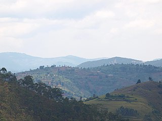
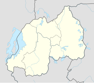
Rwanda, officially the Republic of Rwanda, is a country in Central and East Africa and one of the smallest countries on the African mainland. Located a few degrees south of the Equator, Rwanda is bordered by Uganda, Tanzania, Burundi and the Democratic Republic of the Congo. Rwanda is in the African Great Lakes region and is highly elevated; its geography is dominated by mountains in the west and savanna to the east, with numerous lakes throughout the country. The climate is temperate to subtropical, with two rainy seasons and two dry seasons each year.

Rwanda gained its independence on July 1, 1962. Politics of Rwanda reflects Belgian and German civil law systems and customary law takes place in a framework of a presidential republic, whereby the President of Rwanda is both head of state and head of government, and of a multi-party system. Executive power is exercised by the government.

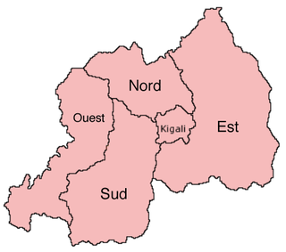
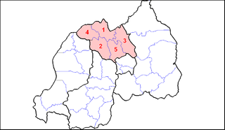
Kigali is the capital and largest city of Rwanda. It is near the nation's geographic centre. The city has been Rwanda's economic, cultural, and transport hub since it became capital at independence in 1962. The city hosts the main residence and offices of the President of Rwanda and government ministries. The city is within the province of Kigali City, which was enlarged in January 2006, as part of local government reorganisation in the country. Kigali's city limits cover the whole province; it is consolidated. The city's urban area covers about 70% of the municipal boundaries.

South Kivu is one of 26 provinces of the Democratic Republic of the Congo. Its capital is Bukavu.
The Anglican Mission in the Americas (AMiA) or The Anglican Mission (AM) is a self-governing church inheriting its doctrine and form of worship from the Episcopal Church in the United States (TEC) and Anglican Church of Canada with members and churchmen on a socially conservative mark on the liberal–fundamentalist spectrum of interpretation of the Bible. Among its affiliates is the Anglican Church in North America since their inception on June 2009, initially as a full member, changing its status to ministry partner in 2010. In 2012, the AM sought to clarify the clear intent of its founding by officially recognizing themselves as a "Society of Mission and Apostolic Works". At the same time, ceased its participation in the Anglican Church in North America and—in order to maintain ecclesial legitimacy—sought oversight from other Anglican Communion provinces.

Kigali-Rural Province, known in Kinyarwanda as Kigali-Ngali, was a province that surrounds the city of Kigali, Rwanda. It was abolished in 2006, along with other existing provinces at the time, in favour of a system of redrawn provinces.

Until January 2006, Umutara Province was one of the 12 provinces (intara) of Rwanda. However, due to local government reorganization, this area is now part of the new larger Eastern Province.
Gitarama was one of the former twelve provinces (intara) of Rwanda and was situated in the centre of the country, to the west of the capital Kigali. Gitarama Prefecture was created in 1959, increasing the number of prefectures of Rwanda from eight to nine. In 2002, it was renamed a province, as were the other prefectures of Rwanda. It had an area of 2,187 square kilometres and a population of some 851,451 prior to its dissolution in January 2006. Gitarama was divided into 8 districts: Muhanga, Kayumbu, Kabagali, Ntenyo, Kamonyi, Ntongwe, Ndiza and Ruyumba; and two towns: Ruhango and Gitarama. Gitarama bordered the provinces Butare, Gikongoro, Kibuye, Gisenyi, Ruhengeri, Kigali-Ngali and Kigali City Tourist attractions included the Kamegeri rocks and the Busaga forest.

Ruhengeri Province was one of the twelve provinces of Rwanda until the end of 2005, when boundaries were redrawn to create five multiethnic provinces. The province was in the north of the country, bordered to the north by Uganda and to the northwest by the Democratic Republic of Congo. It consisted of 10 districts.
Muhanga is a city in Rwanda, in the Muhanga District, in Southern Province. The city is 5,945 feet (1,812 m) above sea level.

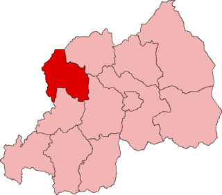
Western Province is one of Rwanda's five provinces. It was created in early January 2006 as part of a government decentralization program that re-organized the country's local government structures.
ISO 3166-2:RW is the entry for Rwanda in ISO 3166-2, part of the ISO 3166 standard published by the International Organization for Standardization (ISO), which defines codes for the names of the principal subdivisions of all countries coded in ISO 3166-1.

Ngororero District is a district (akarere) in Western Province, Rwanda. Its capital is the town of Ngororero.

The Province of Kibuye was, between 2002 and 2006, one of the 12 provinces of Rwanda. Kibuye, Rwanda was the "capital" . The territorial reform on 1 January 2006 merged the province with the provinces of Cyangugu and Gisenyi, to create the new Western Province.
Gisenyi Province was one of the 12 provinces of Rwanda prior to 2006. It is now part of the Western Province.