Guinea, officially the Republic of Guinea, is a coastal country in West Africa. It borders the Atlantic Ocean to the west, Guinea-Bissau to the northwest, Senegal to the north, Mali to the northeast, Cote d'Ivoire to the southeast, and Sierra Leone and Liberia to the south. It is sometimes referred to as Guinea-Conakry after its capital Conakry, to distinguish it from other territories in the eponymous region such as Guinea-Bissau and Equatorial Guinea. It has a population of 13.5 million and an area of 245,857 square kilometres (94,926 sq mi).

Guinea is a country on the coast of West Africa and is bordered by Guinea-Bissau, Senegal, Mali, Ivory Coast, Liberia, and Sierra Leone.
The Guinean Armed Forces are the armed forces of Guinea. They are responsible for the territorial security of Guinea's border and the defence of the country against external attack and aggression.

Conakry is the capital and largest city of Guinea. A port city, it serves as the economic, financial and cultural centre of Guinea. Its population as of the 2014 Guinea census was 1,660,973.
ISO 3166-2:GN is the entry for Guinea in ISO 3166-2, part of the ISO 3166 standard published by the International Organization for Standardization (ISO), which defines codes for the names of the principal subdivisions of all countries coded in ISO 3166-1.

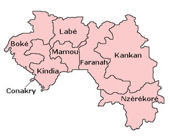
Guinea is divided into 8 regions among which the national capital Conakry ranks as a special zone. The other 7 regions are further subdivided into 33 prefectures and thence into sub-prefectures; which are later subdivided into local units and further subdivided into smaller units.

Kankan is the largest city in Guinea in land area, and the third largest in population, with a population of 1 980 130 people as of 2020. The city is located in eastern Guinea about 555 kilometres east of the national capital Conakry.
Guinée forestière is a forested mountainous region in southeastern Guinea, extending into northeastern Sierra Leone. It is one of four natural regions into which Guinea is divided and covers 23% of the country. It includes all of the Nzérékoré administrative region, and shares a border with Sierra Leone and Liberia. Its rocky topology contains several mountain ranges and has an average elevation of 460m. Forested Guinea contains important areas of biological diversity such as the UNESCO World Heritage site Mount Nimba Strict Nature Reserve and biosphere reserve Ziama Massif. The Guéckédou prefectures also recorded the initial case of the 2014 Ebola outbreak in Meliandou, a rural village. The virus subsequently spread to urban areas and neighbouring countries Sierra Leone and Liberia.

The Kankan region now has more than 6,167,904 inhabitants (2021) the most popular region of Guinea The region has five (5) prefectures, 53 sub-prefectures, 5 urban communes, 53 rural communes, 878 arrondissements, 68 neighborhoods and 1864 sectors.
Articles related to Guinea include:

Pita , is a town in the Fouta Djallon highlands of Guinea. It is the capital and largest urban center of the Pita Prefecture.
The following outline is provided as an overview of and topical guide to Guinea:
Kouré is a small town on the outskirts of Conakry, and within the administrative remit of the capital city of Guinea, the Capital Region.
The Republic of Guinea is a multilingual country, with over 40 languages spoken. The official language is French, which was inherited from colonial rule.

Kaloum is an urban sub-prefecture in the Conakry Region of Guinea and one of five in the capital Conakry. Kaloum includes the city centre of Conakry. As of 2014 it had a population of 62,675 people.
The following is a timeline of the history of the city of Conakry, Guinea.
Maritime Guinea, also known as Lower Guinea, is one of the four natural regions of Guinea. It is located in the west of the country, between the Atlantic Ocean and the Fouta Djallon plateau. Conakry, Guinea's capital and largest city, is located in the region.
Parliamentary elections were held in Guinea on 22 March 2020 alongside a constitutional referendum, after being postponed four times from the original date of January 2019.

On 5 September 2021, President of Guinea Alpha Condé was captured by the country's armed forces in a coup d'état after gunfire in the capital, Conakry. Special forces commander Mamady Doumbouya released a broadcast on state television announcing the dissolution of the constitution and government.