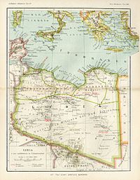
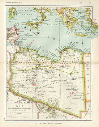
Benghazi Province, or Provincia di Bengasi in Italian, was one of the provinces of Libya under Italian rule. It was established in 1937.
Benghazi Province, or Provincia di Bengasi in Italian, was one of the provinces of Libya under Italian rule. It was established in 1937.

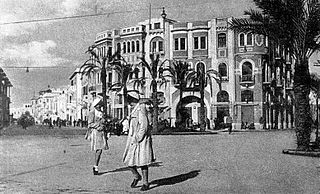
Benghazi Province was located in northern Italian Libya, in western Cyrenaica. Its administrative center was the city of Benghazi on the Mediterranean coast.
It was divided in three sections ("Circondari" in Italian) called in Italian language:
The Italians conquered from the Ottomans in 1911 a region around Benghazi that was very poor and underdeveloped: it had no asphalted road, no telegraph services, no sewage systems, and no hospitals (in 1874 Benghazi had been depopulated by the bubonic plague). In ten years they built all these infrastructures and by the early 1930s a new port & airport and a railways station were created in Benghazi. Indeed in those years in Benghazi were created -for the first time in Cyrenaica's History- the first manufacturing industries, that included salt processing, oil refining, food processing, cement manufacturing, tanning, brewing and sponge and tuna fishing.
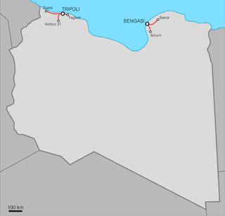
In the 1920s in the Benghazi province was created a railway between Benghazi (called Bengasi in Italian) and Barce: a 750 mm (2 ft 5 1⁄2 in) (later 950 mm) gauge railway was built east from Benghazi; the main route was 110 kilometres (68 mi) long to Marj and was opened in stages between 1911 and 1927. Benghazi also had a 56 kilometres (35 mi) branch to Suluq opened in 1926. [2]
In the late 1930s in the Benghazi province were settled thousands of Italians as farmers in special villages. [3] Most of the Italians were concentrated in Italian Benghazi, where they were in 1939 nearly one third of the population.
According to the 1939 Census Benghazi had 66,801 inhabitants, of whom 23,075 were Italians. [4]
In the late 1930s the province had a huge economic development, mainly in agriculture and commerce, but World War II destroyed it.
According to the 1936 census, which allowed citizens to declare their ethnicity, Benghazi's native population was made up of 95.8% Arabs, 0.3% Turks, 0.3% Blacks, 0.2% Berbers, and 3.6% Others. [5]
| Subdivisions |
|  | ||||||||||||
|---|---|---|---|---|---|---|---|---|---|---|---|---|---|---|
| Settlers and Irredentism |
| |||||||||||||
| Architecture |
| |||||||||||||
| Infrastructure | ||||||||||||||
| Political concepts | ||||||||||||||
| Police and military |
| |||||||||||||
| Currencies and Stamps | ||||||||||||||

Cyrenaica or Kyrenaika, is the eastern region of Libya. Cyrenaica includes all of the eastern part of Libya between the 16th and 25th meridians east, including the Kufra District. The coastal region, also known as Pentapolis in antiquity, was part of the Roman province of Crete and Cyrenaica, later divided into Libya Pentapolis and Libya Sicca. During the Islamic period, the area came to be known as Barqa, after the city of Barca.

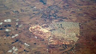
Benghazi is the second-most-populous city in Libya as well as the largest city in Cyrenaica, with an estimated population of 859,000 in 2023. Located on the Gulf of Sidra in the Mediterranean, Benghazi is also a major seaport.

The history of the Jews in Libya stretches back to the 3rd century BCE, when Cyrenaica was under Greek rule. The Jewish population of Libya, a part of the Sephardi-Maghrebi Jewish community, continued to populate the area continuously until modern times. During World War II, Libya's Jewish population was subjected to antisemitic laws by the Fascist Italian regime and deportations by both the Italian and German armies.

The Italian colonizationof Libya began in 1911 and it lasted until 1943. The country, which was previously an Ottoman possession, was occupied by Italy in 1911 after the Italo-Turkish War, which resulted in the establishment of two colonies: Italian Tripolitania and Italian Cyrenaica. In 1934, the two colonies were merged into one colony which was named the colony of Italian Libya. In 1937, this colony was divided into four provinces, and in 1939, the coastal provinces became a part of metropolitan Italy as the Fourth Shore. The colonization lasted until Libya's occupation by Allied forces in 1943, but it was not until the 1947 Paris Peace Treaty that Italy officially renounced all of its claims to Libya's territory.

Libya was a colony of Fascist Italy located in North Africa, in what is now modern Libya, between 1934 and 1943. It was formed from the unification of the colonies of Cyrenaica and Tripolitania, which had been Italian possessions since 1911.
Italian Tripolitania was an Italian colony, located in present-day western Libya, that existed from 1911 to 1934. It was part of the territory conquered from the Ottoman Empire after the Italo-Turkish War in 1911. Italian Tripolitania included the western northern half of Libya, with Tripoli as its main city. In 1934, it was unified with Italian Cyrenaica in the colony of Italian Libya. In 1939, Tripolitania was considered a part of the Kingdom of Italy's 4th Shore.
Italian Cyrenaica was an Italian colony, located in present-day eastern Libya, that existed from 1911 to 1934. It was part of the territory conquered from the Ottoman Empire during the Italo-Turkish War of 1911, alongside Italian Tripolitania.

Italian Libyans are Libyan-born citizens who are fully or partially of Italian descent, whose ancestors were Italians who emigrated to Libya during the Italian diaspora, or Italian-born people in Libya. Most of the Italians moved to Libya during the Italian colonial period.

Few railway stations were built in Libya during the 20th century. The ones that were built were by the Italians from the 1920s as part of their colonial administration. Today there are no functioning railway stations active in the country, but new ones are planned, as part of a new railroad system.

The Libyan Coastal Highway, formerly the Litoranea Balbo, is a highway that is the only major road that runs along the entire east-west length of the Libyan Mediterranean coastline. It is a section in the Cairo–Dakar Highway #1 in the Trans-African Highway system of the African Union, Arab Maghreb Union and others.
Marj, El Merj in Benghazi and Egyptian Arabic, is a city in northeastern Libya and the administrative seat of the Marj District. It lies in an upland valley separated from the Mediterranean Sea by a range of hills, part of the Jebel Akhdar Mountains, and is generally believed to be the site of the ancient city of Barca.

Libyan railways are the Italian colonial railways in Italian Libya. They are related to the development of the railways in the Italian colonial empire. This history started with the opening in 1888 of a short section of line in Italian Eritrea, and ended in 1947 with the loss of Italian Libya after the Allied offensive in North Africa and the destruction of the railways around Italian Tripoli. The railways in the Italian colonial empire reached 1,561 km before World War II.
Tripoli Province was one of the provinces of Libya under Italian rule. It was established in 1937, with the official name: Commissariato Generale Provinciale di Tripoli. It lasted until 1947.

Misrata Governorate was one of the governorates (muhafazah) of Libya from 1963 to 1983. Its capital was the town of Misrata. Initially in the 1930s was called "Provincia di Misurata" of Italian Libya. It was created out of the eastern part of Tripolitania province.

The area of North Africa which has been known as Libya since 1911 was under Roman domination between 146 BC and 672 AD. The Latin name Libya at the time referred to the continent of Africa in general. What is now coastal Libya was known as Tripolitania and Pentapolis, divided between the Africa province in the west, and Crete and Cyrenaica in the east. In 296 AD, the Emperor Diocletian separated the administration of Crete from Cyrenaica and in the latter formed the new provinces of "Upper Libya" and "Lower Libya", using the term Libya as a political state for the first time in history.
Darnah Province was one of the provinces of Libya under Italian rule. It was established in 1937 with the official name: "Commissariato Generale Provinciale di Derna". Derna province was called only "Darnah District" after World War II.
Italian Libya Railways was a group of railways built in the Italian colony of Libya between the two World Wars.
The Southern Military Territory was a jurisdictional territory within the Italian colonies of Cyrenaica and Tripolitania (1911-1934) and later Italian Libya (1934–1947), administered by the Italian military in the Libyan Sahara.
Italian Benghazi was the name used during the Italian colonization of Libya for the port-city of Benghazi in Italian Cyrenaica.
The following is a timeline of the history of the city of Benghazi, Libya.