List of railway stations in Eritrea

Last updated

Eritrean Railways at their greatest extension before WWII Rete ferroviaria Eritrea Italiana.png
Eritrean Railways at their greatest extension before WWII

This article is a list of the railway stations in Eritrea .
The Eritrean Railway originally ran from Massawa, a port on the Red Sea, via the capital Asmara to Agordat. The line can be divided into three sections (Massawa-Asmara; Asmara-Keren; Keren-Agordat). Additionally there was until WW2 a potash line, that was used also for civilian service.

Contents

Massawa to Asmara

The route was built between 1887 and 1910 by the Italians, who made the two main stations (Asmara and Massawa) with typical structures of railway stations in small Italian cities.

As of 2008, this is the only section open.

NameImageDistance [1] Altitude [1] Coordinates
Massawa Massawa station - 2008-10-31.jpg 0.0 km (0.0 mi)3 m (10 ft) 15°36′24″N39°27′58″E / 15.606546°N 39.466163°E / 15.606546; 39.466163
Campo di Marte D 27 Campo di Marte.jpg 2.8 km (1.7 mi)9 m (30 ft) 15°36′52″N39°26′42″E / 15.6144297°N 39.4450754°E / 15.6144297; 39.4450754
Otumlo [2] 13 - Ponte protettore attraversamento ferrovia e strada provinciale ad Otumlo.jpg 4.6 km (2.9 mi)11 m (36 ft) 15°37′24″N39°25′58″E / 15.6233339°N 39.4328311°E / 15.6233339; 39.4328311
Moncullo Moncullo station - 2008-10-30.jpg 7.7 km (4.8 mi)30 m (98 ft) 15°36′37″N39°24′32″E / 15.61041°N 39.408839°E / 15.61041; 39.408839
Dogali Dogali station - 2008-10-31.jpg 19.6 km (12.2 mi)100 m (328 ft) 15°35′54″N39°18′26″E / 15.5983434°N 39.3071535°E / 15.5983434; 39.3071535
Mai Atal Mai Atal station - 2008-10-31.jpg 29.4 km (18.3 mi)181 m (594 ft) 15°34′06″N39°14′35″E / 15.5682675°N 39.2429334°E / 15.5682675; 39.2429334
Damas Damas station - 2008-10-31.jpg 45.0 km (28.0 mi)416 m (1,365 ft) 15°28′34″N39°12′29″E / 15.476202°N 39.207952°E / 15.476202; 39.207952
Baresa Baresa station - 2008-10-31.jpg 57.1 km (35.5 mi)600 m (1,969 ft) 15°24′05″N39°11′05″E / 15.401421°N 39.184778°E / 15.401421; 39.184778
Ghinda Ghinda station - 2008-11-02.jpg 69.4 km (43.1 mi)888 m (2,913 ft) 15°26′19″N39°06′05″E / 15.438634°N 39.101447°E / 15.438634; 39.101447
Embatkalla Embatkalla station - 2008-11-02.jpg 81.1 km (50.4 mi)1,274 m (4,180 ft) 15°24′02″N39°04′26″E / 15.400438°N 39.07397°E / 15.400438; 39.07397
Nefasit Nefasit station - 2008-10-30.jpg 93.0 km (57.8 mi)1,672 m (5,486 ft) 15°20′07″N39°03′48″E / 15.335212°N 39.063274°E / 15.335212; 39.063274
Arbaroba Arbaroba station - 2008-11-04.jpg 104.9 km (65.2 mi)2,064 m (6,772 ft) 15°20′48″N39°00′27″E / 15.346758°N 39.007419°E / 15.346758; 39.007419
Asmara Asmara Railway Station (8351472009).jpg 117.6 km (73.1 mi)2,342 m (7,684 ft) 15°20′20″N38°56′58″E / 15.338936°N 38.949323°E / 15.338936; 38.949323

Asmara to Keren

Keren railway station - now used as a bus station and market Keren station - 2008-11-01.jpg
Keren railway station – now used as a bus station and market

This section (with the stations) was built between 1911 and 1923. The railway generally followed the Anseba River and one of its tributaries through the mountains between Zazzega and Halib Mentel.

Halib Mentel Station Halib Mentel Station 1301.jpg
Halib Mentel Station
NameDistance [1] Altitude [1] Coordinates
Tzada Cristian 127.2 km (79.0 mi)2,292 m (7,520 ft) 15°20′14″N38°50′54″E / 15.337200°N 38.848235°E / 15.337200; 38.848235
Zazzega 136.8 km (85.0 mi)2,217 m (7,274 ft) 15°21′13″N38°48′32″E / 15.353530°N 38.808876°E / 15.353530; 38.808876
Dem Sabai 148.5 km (92.3 mi)1,988 m (6,522 ft) 15°24′45″N38°46′04″E / 15.412373°N 38.767746°E / 15.412373; 38.767746
Andenna 156.6 km (97.3 mi)1,907 m (6,257 ft) 15°27′31″N38°45′40″E / 15.458534°N 38.761063°E / 15.458534; 38.761063
Abrascico 164.9 km (102.5 mi)1,783 m (5,850 ft) 15°30′32″N38°44′08″E / 15.508964°N 38.735621°E / 15.508964; 38.735621
Amba Derho 176.3 km (109.5 mi)1,688 m (5,538 ft) 15°34′46″N38°41′43″E / 15.579392°N 38.695315°E / 15.579392; 38.695315
Furkuto 185.7 km (115.4 mi)1,635 m (5,364 ft) 15°38′01″N38°39′37″E / 15.633484°N 38.660290°E / 15.633484; 38.660290
Elabered 195.3 km (121.4 mi)1,468 m (4,816 ft) 15°40′55″N38°36′53″E / 15.681942°N 38.614706°E / 15.681942; 38.614706
Halib Mentel 209.9 km (130.4 mi)1,423 m (4,669 ft) 15°44′43″N38°32′50″E / 15.745387°N 38.547237°E / 15.745387; 38.547237
Keren 221.7 km (137.8 mi)1,390 m (4,560 ft) 15°46′37″N38°27′13″E / 15.776962°N 38.453618°E / 15.776962; 38.453618

Keren to Agordat

Agordat station, built in Arabesque style Agordat Airport 1982.jpg
Agordat station, built in Arabesque style

This section was built between 1924 and 1929.

NameDistance [1] Altitude [1] Coordinates
Asciadira 232.7 km (144.6 mi)1,204 m (3,950 ft) 15°45′49″N38°23′25″E / 15.763700°N 38.390402°E / 15.763700; 38.390402
Hummed 245.7 km (152.7 mi)935 m (3,068 ft) 15°44′20″N38°19′25″E / 15.738949°N 38.323677°E / 15.738949; 38.323677
Agat 253.3 km (157.4 mi)864 m (2,835 ft)
Darotai 262.5 km (163.1 mi)795 m (2,608 ft)
Mai Adarte 271.4 km (168.6 mi)750 m (2,461 ft) 15°39′19″N38°08′01″E / 15.655361°N 38.133637°E / 15.655361; 38.133637
Umfutat 284.6 km (176.8 mi)669 m (2,195 ft)
Carobel 296.4 km (184.2 mi)677 m (2,221 ft)
Agordat 306.4 km (190.4 mi)606 m (1,988 ft) 15°32′46″N37°52′52″E / 15.546063°N 37.881155°E / 15.546063; 37.881155

Beyond Agordat

Beyond Agordat, the rails were laid as far as Bishia, another 31 kilometres (19 mi), with plans to extend to Ellit and Teseney, [3] linking with the railway network in Sudan. However this section was never completed. [4]

There would have been a break-of-gauge at the connection between Sudan and Eritrea.

NameDistanceAltitudeComments
Agordat 232.7 km (144.6 mi)606 m (1,988 ft)
Bishia 263.7 km (163.9 mi),715 m (2,346 ft) 15°29′24″N37°32′48″E / 15.490014°N 37.546572°E / 15.490014; 37.546572
Ellit 290.7 km (180.6 mi)735 m (2,411 ft)km uncertain
Teseney 301.0 km (187.0 mi)600 m (1,969 ft)km uncertain
Flag of Sudan.svg Kassala, Sudan351.0 km (218.1 mi)531 m (1,742 ft)km uncertain; Near Eritrea-Sudan border

Potash railway

A 42 kilometres (26 mi) line carrying potash was built to serve the following locations: [5]

The 600 mm (1 ft 11+58 in) gauge line was active from 1905: a 600-mm track gauge line was built by the Italians inside the port of Mersa Fatuma [6] and from it into the hinterland until Kululi near the Ethiopian border. This was the main source of potash in Eritrea and had to cease operations because of the Great Depression of 1929. [7]

See also

Related Research Articles

Transport in Eritrea

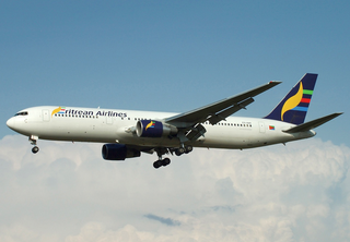
Transport in Eritrea includes highways, airports and seaports, in addition to various forms of public and private vehicular, maritime and aerial transportation.

Asmara Capital and largest city of Eritrea

Asmara, or Asmera, is the capital and most populous city of Eritrea, in the country's Central Region. It sits at an elevation of 2,325 metres (7,628 ft), making it the sixth highest capital in the world by altitude. The city is located at the tip of an escarpment that is both the northwestern edge of the Eritrean Highlands and the Great Rift Valley in neighbouring Ethiopia. In 2017, the city was declared as a UNESCO World Heritage Site for its well-preserved modernist architecture. The site of Asmera was first settled in 800 BC with a population ranging from 100 to 1,000. The city was then founded in the 12th century AD after four separate villages unified to live together peacefully after long periods of conflict. Under Italian rule the city of Asmara was made capital of Eritrea in the last years of the 19th century.

Eritrean Railway Railway system of Eritrea

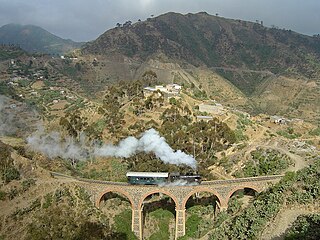
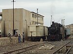
The Eritrean Railway is the only railway system in Eritrea. It was constructed between 1887 and 1932 during the Italian Eritrea colony and connects the port of Massawa with Asmara. Originally it also connected to Bishia. The line was partly damaged by warfare in subsequent decades, but was rebuilt in the 1990s. Vintage equipment is still used on the line.

Massawa City in Semienawi Keyih Bahri Region, Eritrea

Massawa is a port city in the Northern Red Sea region of Eritrea, located on the Red Sea at the northern end of the Gulf of Zula beside the Dahlak Archipelago. It has represented a historically important port for many centuries.

Asmara-Massawa Cableway Aerial lift in Asmara, Eritrea

The Asmara-Massawa Cableway was a cableway built in Italian Eritrea before World War II.The Eritrean Ropeway, completed in 1937, ran 71.8 km from the south end of Asmara to the city-port of Massawa.

Keren, Eritrea Capital of Anseba Region, Eritrea

Keren, historically known as Sanhit, is the second-largest city in Eritrea. It is situated around 91 kilometres (57 mi) northwest of Asmara at an elevation of 1,390 metres (4,560 ft) above sea-level. The city sprawls on a wide basin surrounded by granitic mountains on all sides. It serves as the capital of the Anseba Region, and is home to a number of ethnic groups including the Bilen people, Tigre people and Tigrinya people.

Agordat Town in Gash-Barka, Eritrea

Agordat; also Akordat or Ak'ordat) is a city in Gash-Barka, Eritrea. It was the capital of the former Barka province, which was situated between the present-day Gash-Barka and Anseba regions.

Rail transport in Ethiopia is done within the National Railway Network of Ethiopia, which currently consists of three electrified standard gauge railway lines: the Addis Ababa–Djibouti Railway, the Awash–Weldiya Railway and the Weldiya–Mekelle Railway. Other lines are still in the planning phase. There is also an urban light rail system in the country's capital, the Addis Ababa Light Rail.

Dallol (ghost town) Ghost town in Afar Region, Ethiopia

Dallol is a locality in the Dallol woreda of northern Ethiopia. Located in Administrative Zone 2 of the Afar Region in the Afar Depression, it has a latitude and longitude of 14°14′19″N40°17′38″E with an elevation of about 130 metres (430 ft) below sea level. The Central Statistical Agency has not published an estimate for the 2005 population of the village, which has been described as a ghost town.

Ibrahim Sultan Ali

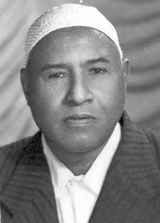
Ibrahim Sultan Ali was born in Keren, Eritrea. He played a part in the emancipation of Tigre in Sahel and Barka and in establishing Blocco Independenza. He was also the Secretary General of the Eritrean Democratic Front (EDF).

Articles related to Eritrea include:

Battle of Keren 1941 battle in Africa

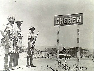
The Battle of Keren took place from 3 February to 27 March 1941. Keren was attacked by the British during the East African Campaign of the Second World War. A force of Italian regular and colonial troops defended the position against British troops and Free French forces. The town of Keren, in the colony of Italian East Africa, was of tactical importance to both sides. The road and railway through Keren were the main routes to the colonial capital of Italian Eritrea at Asmara and the Red Sea port of Massawa, which surrendered to the British after the battle.

Eritrea Country in the Horn of Africa

Eritrea, officially the State of Eritrea, is a country in the Horn of Africa region of Eastern Africa, with its capital at Asmara. It is bordered by Ethiopia in the south, Sudan in the west, and Djibouti in the southeast. The northeastern and eastern parts of Eritrea have an extensive coastline along the Red Sea. The nation has a total area of approximately 117,600 km2 (45,406 sq mi), and includes the Dahlak Archipelago and several of the Hanish Islands.

Mogadishu–Villabruzzi Railway

The Mogadiscio-Villabruzzi Railway is an historical railway system that ran through southern Somalia. It was constructed between 1914 and 1927 by the colonial authorities in Italian Somaliland. The railway connected the capital city Mogadishu with Afgooye, and subsequently with Villaggio Duca degli Abruzzi - usually called "Villabruzzi". The line was later dismantled by British troops during World War II. Plans for re-establishing the railway were made in the 1980s by the Siad Barre administration, but were aborted after the regime's collapse.

Libyan Railways

Libyan railways are the Italian colonial railways in Italian Libya. They are related to the development of the railways in the Italian colonial empire. This history started with the opening in 1888 of a short section of line in Italian Eritrea, and ended in 1947 with the loss of Italian Libya after the Allied offensive in North Africa and the destruction of the railways around Italian Tripoli. The railways in the Italian colonial empire reached 1,561 km before World War II.

Italian Eritrea 1882–1936 Italian colony in modern Eritrea

Italian Eritrea was a colony of the Kingdom of Italy in the territory of present-day Eritrea. The first Italian establishment in the area was the purchase of Assab by the Rubattino Shipping Company in 1869, which came under government control in 1882. Occupation of Massawa in 1885 and the subsequent expansion of territory would gradually engulf the region and in 1889 borders with the Ethiopian Empire were defined in the Treaty of Wuchale. In 1890 the Colony of Eritrea was officially founded.

Narrow-gauge railways in Africa

Narrow-gauge railways are common in Africa, where great distances, challenging terrain and low cost have made the narrow gauges attractive. Many nations, particularly in Southern Africa, including the extensive South African Railway network (Spoornet), use a 3 ft 6 in gauge. Metre gauge is also common, as in the case of the Uganda Railway. There used to be extensive 2 ft and 600 mm gauge networks in countries such as Morocco, Congo, Angola, Namibia and South Africa, but these have mostly been dismantled or converted. Some also survive in Egypt: in the countryside around Luxor, narrow-gauge railways are used for the transportation of sugar cane.

Railway stations in Italian Somaliland

The Railway Stations in Somaliland were served by the Mogadishu–Villabruzzi Railway of 114 km.

Battle of Agordat (1941)

The Battle of Agordat was fought near Agordat in Eritrea from 26 to 31 January 1941, by the Italian army and Royal Corps of Colonial Troops against British, Commonwealth and Indian forces, during the East African Campaign of the Second World War. The British had the advantage of breaking Italian codes and cyphers before the offensive and received copious amounts of information from Italian sources on the order of battle and plans of the Regia Aeronautica and the Italian army.

Italian colonial railways

The Italian colonial railways started with the opening in 1888 of a short section of line in Italian Eritrea, and ended in 1943 with the loss of Italian Libya after the Allied offensive in North Africa and the destruction of the railways around Italian Tripoli. The colonial railways of the Kingdom of Italy reached 1,561 kilometres (970 mi) before WWII.

References

  1. 1 2 3 4 5 6 Railways Administration in Eritrea. Imperial Ethiopian Government. 16 November 1965.
  2. Photo of Otumlo station
  3. Map of 1938 Italian Eritrea showing the expansion planned toward Ethiopia and Sudan border (the red line continuous is the Massaua-Asmara-Keren-Agordat railway)
  4. "The Eritrean Railway" . Retrieved 24 March 2009.
  5. "Building the line" . Retrieved 24 March 2009.
  6. Meleca: Map of the potash railway from Mersa Fatuma in page 3
  7. Neil Robinson. World Rail Atlas and Historical Summary.North, East and Central Africa. London, 2009 (p.35-39). ISBN   978-954-92184-3-5

Commons-logo.svg Media related to Train stations in Eritrea at Wikimedia Commons