
Transportation in Botswana is provided by an extensive network of railways, highways, ferry services and air routes that criss-cross the country. The transport sector in Botswana played an important role in economic growth following its independence in 1966. The country discovered natural resources which allowed it to finance the development of infrastructure, and policy ensured that the transport sector grew at an affordable pace commensurate with demands for services.

Modes of transport in Mozambique include rail, road, water, and air. There are rail links serving principal cities and connecting the country with Malawi, Zimbabwe and South Africa. There are over 30,000 km of roads, but much of the network is unpaved.

Gaborone is the capital and largest city of Botswana with a population of 246,325 based on the 2022 census, about 10% of the total population of Botswana. Its agglomeration is home to 534,842 inhabitants at the 2022 census.

Palapye is a growing town in Botswana, situated about halfway between Francistown and Gaborone. Over the years its position has made it a convenient stopover on one of Southern Africa's principal north–south rail and road routes.

Francistown is the second-largest city in Botswana, with a population of about 103,417 and 147,122 inhabitants for its agglomeration at the 2022 census. It is located in eastern Botswana, about 400 kilometres (250 mi) north-northeast from the capital, Gaborone. Francistown is located at the confluence of the Tati and Ntshe rivers, and near the Shashe River and 90 kilometres (56 mi) from the international border with Zimbabwe.
Lobatse is a town in south-eastern Botswana, 70 kilometres south of the capital Gaborone, situated in a valley running north towards Gaborone and close to the border with South Africa. Lobatse has a population of 29,772 as of 2022. The town is an administrative district, with a town council.
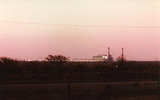
Morupule Thermal Power Station is a coal-fired power station in Botswana. It is responsible for an estimated 80 percent of the country's domestic power generation.
The Trans-Kalahari Corridor is a paved highway corridor that provides a direct route from the port of Walvis Bay and Windhoek in central Namibia, through Botswana, to Pretoria in Gauteng province in South Africa. It initially cost approximately 850 million Namibian dollars and was officially opened in 1998.

Botswana Railways (BR) is the national railway of Botswana.
Ramokgwebana is a village in the North-East District of Botswana, close to the eastern border, which is defined by the Ramokgwebana River. Plumtree, Zimbabwe is on the other side of the border crossing.
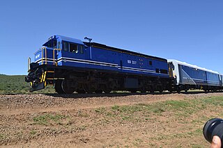
Rail services in Botswana are provided by Botswana Railways. Most routes in the country radiate from Gaborone. The railway network consists of 888 km of track; its gauge is 1,067 mm cape gauge.

Portos e Caminhos de Ferro de Moçambique is a state-owned company that oversees the railway system of Mozambique and its connected ports.
Serule is a village in Central District of Botswana. Serule, with a latitude of -21.95 and a longitude of 27.3, is a streets, highways, roads, or railroad. The village is located along the road between Francistown and Palapye, and is an important railroad junction with rails leading towards north to Francistown, south to Palapye and east to the mining town of Selebi-Phikwe, 72 km from Palapye north up the A1 road, 88 km from Francistown down south the A1 road and 60 km west of Selibe Phikwe to the T-junction. The location is situated 340 kilometres east (90°) of the approximate centre of Botswana and 332 kilometres north east (26°) of the capital Gaborone.
Railway stations in Mozambique include:
Railway station in Beitbridge include:

The A1 highway in Botswana is a road that runs from the Zimbabwean border near Ramokgwebana through Francistown, Mahalapye, Palapye, Gaborone and Lobatse, to Ramatlabama at the border with South Africa. Crossing the Ramokgwebana River into Zimbabwe, it continues as the A7 to Bulawayo. On the South African end it continues as the N18 to Mahikeng.

First Capital Bank Botswana Limited, formerly known as Capital Bank, is a commercial bank in Botswana, licensed by the Bank of Botswana, the central bank and national banking regulator. It is a subsidiary of FMBCapital Holdings Plc, a Mauritius-based financial services conglomerate, whose shares of stock are listed on the Malawi Stock Exchange and has subsidiaries in Botswana, Malawi, Mozambique, Zambia and Zimbabwe.

The rail service in Namibia is provided by TransNamib. The Namibian rail network consists of 2,687 km of tracks (2017).
The Palapye Solar Power Station, also Lotsane Solar Power Station, is a 100 MW (130,000 hp) solar power station, under development in Botswana. The solar farm is owned and is being developed by Solarcentury from the United Kingdom and ENRC from Botswana. The power generated here is intended to be fed into the Southern Africa Power Pool for export. As of February 2024 the development has received a power generation license from the Botswana Energy Regulatory Authority (BERA).
 Francistown
  Mafeking
  Mariental