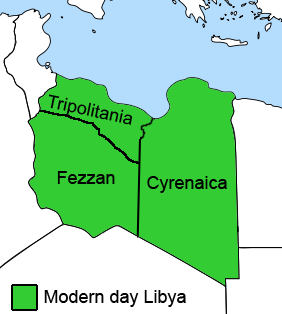
Cyrenaica or Kyrenaika, is the eastern region of Libya. Cyrenaica includes all of the eastern part of Libya between the 16th and 25th meridians east, including the Kufra District. The coastal region, also known as Pentapolis in antiquity, was part of the Roman province of Crete and Cyrenaica, later divided into Libya Pentapolis and Libya Sicca. During the Islamic period, the area came to be known as Barqa, after the city of Barca.

Tripolitania, historically known as the Tripoli region, is a historic region and former province of Libya.

Subdivisions of Libya have varied significantly over the last two centuries. Initially Libya under Ottoman and Italian control was organized into three to four provinces, then into three governorates (muhafazah) and after World War II into twenty-five districts (baladiyah). Successively into thirty-two districts (shabiyat) with three administrative regions, and then into twenty-two districts (shabiyat). In 2012 the ruling General National Congress divided the country into governorates (muhafazat) and districts (baladiyat). While the districts have been created, the governorates have not.

The Provinces of Libya were prescribed in 1934, during the last period of colonial Italian Libya, and continued through post-independence Libya until 1963 when the Governorates system was instituted.

The Italian colonizationof Libya began in 1911 and it lasted until 1943. The country, which was previously an Ottoman possession, was occupied by Italy in 1911 after the Italo-Turkish War, which resulted in the establishment of two colonies: Italian Tripolitania and Italian Cyrenaica. In 1934, the two colonies were merged into one colony which was named the colony of Italian Libya. In 1937, this colony was divided into four provinces, and in 1939, the coastal provinces became a part of metropolitan Italy as the Fourth Shore. The colonization lasted until Libya's occupation by Allied forces in 1943, but it was not until the 1947 Paris Peace Treaty that Italy officially renounced all of its claims to Libya's territory.

This is a survey of the postage stamps and postal history of Tripolitania, now part of Libya.

Pasha of Tripoli was a title that was held by many rulers of Tripoli in Ottoman Tripolitania. The Ottoman Empire ruled the territory for most time from the Siege of Tripoli in 1551 until the Italian invasion of Libya in 1911, at the onset of the Italo-Turkish War.

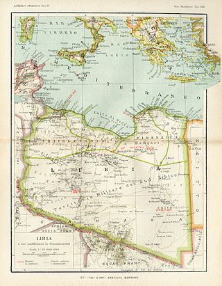
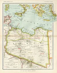
Libya was a colony of Fascist Italy located in North Africa, in what is now modern Libya, between 1934 and 1943. It was formed from the unification of the colonies of Cyrenaica and Tripolitania, which had been Italian possessions since 1911.

Italian Tripolitania was an Italian colony, located in present-day western Libya, that existed from 1911 to 1934. It was part of the territory conquered from the Ottoman Empire after the Italo-Turkish War in 1911. Italian Tripolitania included the western northern half of Libya, with Tripoli as its main city. In 1934, it was unified with Italian Cyrenaica in the colony of Italian Libya. In 1939, Tripolitania was considered a part of the Kingdom of Italy's 4th Shore.

Italian Cyrenaica was an Italian colony, located in present-day eastern Libya, that existed from 1911 to 1934. It was part of the territory conquered from the Ottoman Empire during the Italo-Turkish War of 1911, alongside Italian Tripolitania.

The Libyan Coastal Highway, formerly the Litoranea Balbo, is a highway that is the only major road that runs along the entire east-west length of the Libyan Mediterranean coastline. It is a section in the Cairo–Dakar Highway #1 in the Trans-African Highway system of the African Union, Arab Maghreb Union and others.

This is a survey of the postage stamps and postal history of Cyrenaica, now part of Libya.

This is a survey of the postage stamps and postal history of Libya. Libya is a country located in North Africa. Bordering the Mediterranean Sea to the north, Libya lies between Egypt to the east, Sudan to the southeast, Chad and Niger to the south, and Algeria and Tunisia to the west.

The Allied administration of Libya was the control of the ex-colony of Italian Libya by the Allies from 13 May 1943 until Libyan independence was granted in 1951. It was divided into two parts:

The Southern Military Territory was a jurisdictional territory within the Italian colonies of Cyrenaica and Tripolitania (1911-1934) and later Italian Libya (1934–1947), administered by the Italian military in the Libyan Sahara.

The Second Italo-Senussi War, also referred to as the Pacification of Libya, was a conflict that occurred during the Italian colonization of Libya between Italian military forces and indigenous rebels associated with the Senussi Order. The war lasted from 1923 until 1932, when the principal Senussi leader, Omar al-Mukhtar, was captured and executed. The Libyan genocide took place during and after the conflict.

Postage stamps of Italian Libya were stamps issued by the Kingdom of Italy for use in Italian Libya, between 1912 and 1943.

The Algeria–Libya border is 989 km in length and runs from the tripoint with Tunisia in the north to the tripoint with Niger in the south.


