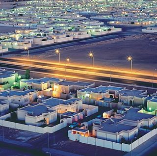
Population
The region's inhabitants include the Berber, the Dawada, the nomadic Tuareg in the southwest, and the Toubou in the southeast. These pastoralist populations often cross the borders of Algeria, Chad and Niger freely. In the north, Arab, Berber and settled Tuareg and Toubou mix. While making up some 30% of the land area of Libya, the Fezzan supports only a small percentage of its population. Large towns like Sabha survive on near-surface water in the wadis of the north and west. The northeast area is dominated by Haruj, a large and unpopulated volcanic field.
Fezzan's population has grown rapidly since the mid-20th century along with the overall growth in Libya's population, and the province's share of the national population has increased by half.
| Year | Population | Percent of
Libya's
population |
|---|
| 1954 | 59,315 | 5.4 |
| 1964 | 79,326 | 5.1 |
| 1973 | 128,012 | 5.7 |
| 1984 | 213,915 | 5.9 |
| 1995 | 352,276 | 7.3 |
| 2006 | 442,090 | 7.8 |
Source: Gathered from bulletins of censuses 1964, 1973, 1995, 2006.

This article is about Libyans (ليبيون) and their population density, ethnicity, education level, health of the populace, economic status, and religious affiliations, as well as other aspects of the Libyan population. No complete population or vital statistics registration exists in Libya.

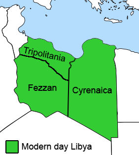
In Libya there are currently 106 districts, second level administrative subdivisions known in Arabic as baladiyat. The number has varied since 2013 between 99 and 108. The first level administrative divisions in Libya are currently the governorates (muhafazat), which have yet to be formally deliniated, but which were originally tripartite as: Tripolitania in the northwest, Cyrenaica in the east, and Fezzan in the southwest; and later divided into ten governorates.

Murzuq is one of the districts of Libya. It is in the south of the country. Its capital is Murzuk. The city was occupied by the Ottoman Empire in 1578 and served as the capital of Fezzan off and on until the Ottomans ceded Libya to Italy in 1912. It was not occupied by the Italians until 1914.

Sabha is one of the districts of Libya. It is located near the center of the country, in the Fezzan region. The capital is the city of Sabha. Sabha District borders the following districts, namely, Wadi Al Shatii in the north, Al Jufrah in the east, Murzuq in the south and Wadi Al Hayaa in the west.

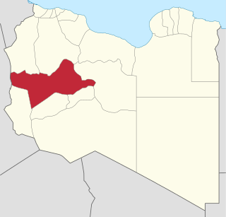
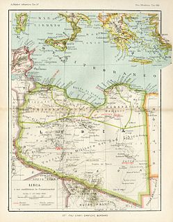
Fezzan is the southwestern region of modern Libya. It is largely desert, but broken by mountains, uplands, and dry river valleys (wadis) in the north, where oases enable ancient towns and villages to survive deep in the otherwise inhospitable Sahara Desert. The term originally applied to the land beyond the coastal strip of Africa proconsularis, including the Nafusa and extending west of modern Libya over Ouargla and Illizi. As these Berber areas came to be associated with the regions of Tripoli, Cirta or Algiers, the name was increasingly applied to the arid areas south of Tripolitania.

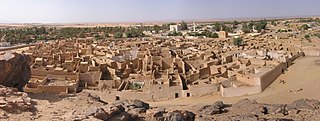
Ubari or Awbari is a Tuareg Berber-speaking oasis town and the capital of the Wadi al Hayaa District, in the Fezzan region of southwestern Libya. It is in the Idehan Ubari, a Libyan section of the Sahara Desert. It was the capital of the former baladiyah (district) called Awbari, in the southwest of the country.
Ghat is the capital of the Ghat District in the Fezzan region of southwestern Libya, located just east of the Algerian border.

Murzuk, Murzuq, Murzug or Merzug is an oasis town and the capital of the Murzuq District in the Fezzan region of southwest Libya. It lies on the northern edge of the Murzuq Desert, an extremely arid region of ergs or great sand dunes which is part of the greater Sahara Desert.

Ghadames or Ghadamis is an oasis Berber town in the Nalut District of the Tripolitania region in northwestern Libya.
The governorates of Libya (muhafazah) were a tenfold top-level administrative division of Libya from 1963 until 1983.
Subdivisions of Libya have varied significantly over the last two centuries. Initially Libya under Ottoman and Italian control was organized into three to four provinces, then into three governorates (muhafazah) and after World War II into twenty-five districts (baladiyah). Successively into thirty-two districts (shabiyat) with three administrative regions, and then into twenty-two districts (shabiyat). In 2012 the ruling General National Congress divided the country into governorates (muhafazat) and districts (baladiyat). While the districts have been created, the governorates have not.

The Provinces of Libya were prescribed in 1934, during the last period of colonial Italian Libya, and continued through post-independence Libya until 1963 when the Governorates system was instituted.
Wadi al Hayaa is one of the districts of Libya. Its capital is the city of Ubari. As of 2006, it had a population of 72,587, area of 31,890 square kilometres (12,310 sq mi) and a population density of 2.28 persons per square kilometer.
Wadi al Shati, sometimes referred to as Ashati, is one of the districts of Libya in the central-west part of the country. The area is mostly desert. Wadi al Shati District is named after the depression of the same name, Wadi Ashati.

Ghat is one of the districts of Libya. Its capital is Ghat. To the west, Ghat borders two provinces of Algeria: Tamanghasset in the far southwest, and Illizi Province. It also has a short border with the Agadez Department of Niger in the far south. Domestically, it borders Wadi Al Shatii in north, Wadi Al Hayaa in northeast and Murzuq in the east.
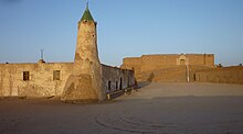
Hun or Houn is an oasis town in the northern Fezzan region of southwest Libya. The town is the capital of the Jufra District. The "International Autumn Tourism Festival" is an annual festival usually held at the end of September.
The Fezzan campaign was a military campaign conducted by the National Liberation Army to take control of southwestern Libya during the Libyan Civil War. During April to June 2011, anti-Gaddafi forces gained control of most of the eastern part of the southern desert region during the Cyrenaican desert campaign. In July, Qatrun changed to anti-Gaddafi control on 17 July and back to pro-Gaddafi control on 23 July. In late August, anti- and pro-Gaddafi forces struggled for control of Sabha.
The Southern Military Territory refers to the jurisdictional territory within the colony of Italian Libya (1911–1947), administered by the Italian military in the Libyan Sahara.

The Ubari Desert, Idehan Ubari, Idehan Awbari or Ubari Erg is an erg in the hyper-arid Fezzan region of southwestern Libya with a surface of approximately 58,000 km². The area of the Ubari desert has been traditionally inhabited by Tuareg people.
Tripolitania province is one of the three traditional Provinces of Libya. It was a formal province from 1934 until 1963, when it was subdivided into the Governorates of Libya. Its capital was the city of Tripoli. Between 1911 and 1934 it had been the separately governed colony of Italian Tripolitania.