Highways in Taiwan are classified into five types:
National Freeway 1, also known as Sun Yat-sen Freeway, is a freeway in Taiwan, the first freeway built in Taiwan. It begins in Keelung at the intersection of Xiao 2nd Road and Zhong 4th Road and ends in Kaohsiung at the intersection of Zhongshan 4th Road and Yugang Road, giving it a total length of 374.3 km (232.6 mi).
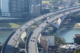
National Freeway 3, also known as Formosa Freeway, is a freeway in Taiwan. It is the second north–south freeway in Taiwan, beginning in Keelung City at Jijin Interchange on the provincial highway 2 and ending in Linbian, Pingtung on the provincial highway 17. It is the longest freeway in Taiwan with the total length of 430.5 km (267.5 mi). The freeway is also the only one in the national freeway system with a spur route, Freeway 3A.

Provincial Highway No. 61 is usually known as West Coast Expressway (西部濱海快速公路). The highway runs along the west coast of Taiwan. Several sections of the highway are freeway standards with no at-grade intersections, while the rest are local highway standards. There are several sections open for the traffic. Others are still under construction.

Taichung is located in central Taiwan and is the third largest city in the island country.
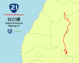
Taiwan Provincial Highway No. 21 is a Provincial Highway in Taiwan that begins Tianleng (天冷), Dongshi District, Taichung City, at the intersection with Provincial Highway No. 8, and ends at Tataka(塔塔加), where it is connected with Provincial Highway No. 18 in Yushan National Park. It is the primary highway to the Sun Moon Lake, a popular tourist destination. The total length is 145 km.
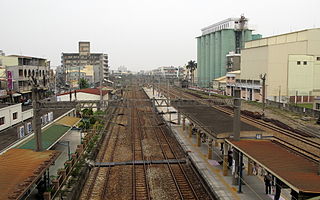
Lujhu District (Chinese: 路竹區; Hanyu Pinyin: Lùzhú Qū; Tongyong Pinyin: Lùjhú Cyu; Wade–Giles: Lu4-chu2 Ch'ü1) is a suburban district of Kaohsiung City, Taiwan.
Provincial Highway 1 is a 461.081 km (286.502 mi)-long Taiwanese provincial highway that starts in the north of the country near Taipei Main Station and ends in the south at Fangshan, Pingtung County. It intersects with Provincial Highway 9 and Provincial Highway 26. Before the freeway system was built in Taiwan, this was the primary north-south highway for the island. The highway connects most of the major cities in Taiwan. In most parts of Taiwan, the road is known as The North-South Highway (縱貫公路).

Kaohsiung Main Station is a railway and metro station in Sanmin District, Kaohsiung, Taiwan served by the Taiwan Railways and Kaohsiung Rapid Transit. It is one of four special class stations, the highest class with the most services. It is currently undergoing reconstruction, scheduled to be complete in 2024.
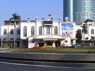
Tainan is a railway station in Tainan, Taiwan served by Taiwan Railways Administration. Situated in centre of the old town square of Tainan, Tainan Station is the main station of the city and also one of the major stations along the western trunk line in Taiwan. The Shalun line, opened in 2011, allows through services to link the station with THSR Tainan Station.

Provincial Highway 3 is a 435.608 km-long Taiwanese highway that starts in Taipei and ends in Pingtung. Also known as Inner-Mountain Highway (內山公路), the road travels through the mountain towns in Western Taiwan and was the major route for the area until NH 3 was built.
Taiwan Ring Expressway is a proposed, hypothetical expressway encircling the island of Taiwan as part of the National Trunk Highway System of the People's Republic of China. It is not in existence and hypothetical due to the political status of Taiwan. The People's Republic of China claims control over Taiwan while it is administered and controlled by the Republic of China. Taiwan has its own highway system and does not recognize the designation by the People's Republic of China.
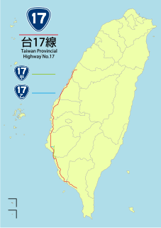
Provincial Highway 17 (PH 17), Chinese: 台17線) is a north–south highway from Qingshui in Taichung City to Fangliao in Pingtung County. The highway is known as Western Coastal Highway (西部濱海公路) since it runs parallel to the western coasts of Taiwan. Since the completion of PH 61 expressway, which parallels PH 17, the latter now mostly handles local traffic. The total length of the highway is 273.474 kilometres (169.929 mi).

Provincial Highway 19 is a north–south highway from Changhua City in Changhua County to Yongkang in Tainan City. The highway is known as Central Highway (中央公路). The highway lies between the coastal PH 17 and the inland PH 1 which serves many of the major cities in central and southern Taiwan. The total length of the highway is 140.195 kilometres (87.113 mi).

Provincial Highway 22 is a highway that started from Nanzih District, just north of downtown Kaohsiung, and ended in Gaoshu, Pingtung County. The highway passes through Dashe, Yanchao, and Cishan in Kaohsiung City, and Ligang in Pingtung County. The highway is known as Qinan Highway (旗楠公路) for the stretch between Cishan and Nanzih. The route length is 34.321 km.
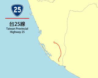
Provincial Highway 25 is a Taiwanese highway that starts from Fengshan and ends in Linyuan, both in Kaohsiung City. The highway is also known as Fenglin Highway (鳳林公路). The route length is 18.275 kilometres (11.356 mi).

Provincial Highway 27 is a Taiwanese highway that starts from Liouguei, Kaohsiung City and ends in Xinyuan, Pingtung, Pingtung County. The highway connects the inland townships in Kaohsiung and Pingtung to the southern coasts of Taiwan. The route length is 79.174 kilometres (49.196 mi).

Provincial Highway 28 is a Taiwanese highway that starts from Hunei and ends in Liouguei. The highway is entirely located in Kaohsiung City. The route length is 49.657 kilometres (30.855 mi).

Provincial Highway 29 is a Taiwanese highway that starts from Namasia and ends in Linyuan. The highway is entirely located in Kaohsiung City. The highway was once the southern segment of Highway 21 until 2014, when it was assigned the current number. The highway is known as Dalin Highway (達林公路) for its entire length. For the segment between Jiaxian and Cishan the highway is known as Qijia Highway (旗甲公路). The route length is 112.26 kilometres (69.76 mi).
The architecture of Taiwan can be traced back to stilt housing of the aborigines in prehistoric times; to the building of fortresses and churches in the north and south used to colonize and convert the inhabitants during the Dutch and Spanish period; the Tungning period when Taiwan was a base of anti-Qing sentiment and Minnan-style architecture was introduced; in Qing dynasty period, a mix of Chinese and Western architecture appeared and artillery battery flourished during Qing's Self-Strengthening Movement; During the Japanese rule of Taiwan, the Minnan, Japanese and Western culture were main influencers in architectural designs and saw the introduction and use of reinforced concrete. Due to excessive Westernization as a colony, after the retrocession of Taiwan to the Republic of China in 1945 from Japan at the end of World War II, Chinese classical style became popular and entered into international mainstream as a postmodern design style. Today, Taiwanese architecture has undergone much diversification, every style of architecture can be seen.


