Transport in Belgium is facilitated with well-developed road, air, rail and water networks. The rail network has 2,950 km (1,830 mi) of electrified tracks. There are 118,414 km (73,579 mi) of roads, among which there are 1,747 km (1,086 mi) of motorways, 13,892 km (8,632 mi) of main roads and 102,775 km (63,861 mi) of other paved roads. There is also a well-developed urban rail network in Brussels, Antwerp, Ghent and Charleroi. The ports of Antwerp and Bruges-Zeebrugge are two of the biggest seaports in Europe. Brussels Airport is Belgium's biggest airport.

The Netherlands is both a very densely populated and a highly developed country in which transport is a key factor of the economy. Correspondingly it has a very dense and modern infrastructure, facilitating transport with road, rail, air and water networks. In its Global Competitiveness Report for 2014-2015, the World Economic Forum ranked the Dutch transport infrastructure fourth in the world.

A wiki is a form of hypertext publication on the internet which is collaboratively edited and managed by its audience directly through a web browser. A typical wiki contains multiple pages that can either be edited by the public or limited to use within an organization for maintaining its internal knowledge base.

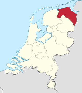
Groningen is the northeasternmost province of the Netherlands. It borders on Friesland to the west, Drenthe to the south, the German state of Lower Saxony to the east, and the Wadden Sea to the north. As of January 2023, Groningen had a population of about 596,000, and a total area of 2,955 km2 (1,141 sq mi).

Drenthe is a province of the Netherlands located in the northeastern part of the country. It is bordered by Overijssel to the south, Friesland to the west, Groningen to the north, and the German state of Lower Saxony to the east. As of January 2023, Drenthe had a population of about 502,000, and a total area of 2,680 km2 (1,030 sq mi).

Overijssel is a province of the Netherlands located in the eastern part of the country. The province's name comes from the perspective of the Episcopal principality of Utrecht, which held the territory until 1528. The capital city of Overijssel is Zwolle and the largest city is Enschede. The province had a population of about 1,184,000 as of January 2023. The land mostly consists of grasslands and some forests ; it also borders a small part of the IJsselmeer to the west.

There are twelve provinces of the Netherlands representing the administrative layer between the national government and the local governments, with responsibility for matters of subnational or regional importance.

European route E30 is an A-Class European route from the port of Cork in Ireland in the west to the Russian city of Omsk, near the border with Kazakhstan in the east. For much of the Russian stretch, it follows the Trans-Siberian Highway and, east of the Ural Mountains, with AH6 of the Asian Highway Network, which continues to Busan, South Korea. The total length is 6,530 km (4,060 mi)—3,300 km (2,100 mi) from Cork to Moscow, and 3,230 km (2,010 mi) from Moscow to Omsk. The naming is by the United Nations Economic Commission for Europe (UNECE).

EuroVelo is a network of 17 long-distance cycling routes criss-crossing Europe, with 2 more in early construction across various stages of completion. When completed, the EuroVelo network's total length will be almost 60,875 km (37,826 mi). As of 2023 more than 56,000 km (35,000 mi) were in place. EuroVelo is a project of the European Cyclists' Federation (ECF). The multinational project aims to connect 40 countries via the 19 unique routes across the European continent.

A bicycle boulevard, sometimes referred to as a neighborhood greenway, neighborway, neighborhood bikeway or neighborhood byway is a type of bikeway composed of a low-speed street which has been "optimized" for bicycle traffic. Bicycle boulevards discourage cut-through motor-vehicle traffic but may allow local motor-vehicle traffic at low speeds. They are designed to give priority to bicyclists as through-going traffic. They are intended as a low-cost, politically popular way to create a connected network of streets with good bicyclist comfort and/or safety.

List of A roads in the zone 7 in Great Britain starting north of the Solway Firth/Eden Estuary, west of the A7 and south of the A8. Data from Openstreetmap.
GeoBase is a federal, provincial and territorial government initiative that is overseen by the Canadian Council on Geomatics (CCOG). It is undertaken to ensure the provision of, and access to, a common, up-to-date and maintained base of quality geospatial data for Canada. Through the GeoBase, users with an interest in geomatics have access to quality geospatial information at no cost and with unrestricted use.
Lensworld–Kuota is a former professional cycling team based in Belgium, which competed in elite road bicycle racing events such as the UCI Women's Road World Cup.

The Netherlands has a public road network totaling 139,000 km, one of the densest in the world. Its use has increased since the 1950s and now exceeds 200 billion km traveled per year, three quarters of which is by car, making it among the most intensely used road networks. In 2019, the World Economic Forum ranked the quality of Dutch road infrastructure as the best in Europe and second to Singapore out of 141 countries.

Provincial road N201 is a Dutch provincial road.


