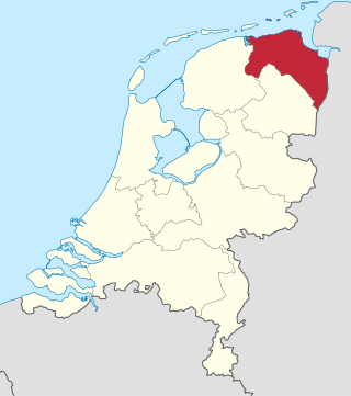
Groningen is the northeasternmost province of the Netherlands. It borders on Friesland to the west, Drenthe to the south, the German state of Lower Saxony to the east, and the Wadden Sea to the north. As of January 2023, Groningen had a population of about 596,000, and a total area of 2,955 km2 (1,141 sq mi).
Bellingwedde was a municipality in the province Groningen in the northeast of the Netherlands. Bellingwedde was established in 1968, when the municipalities of Bellingwolde and Wedde merged. After almost 50 years, Bellingwedde was disestablished in 2018, when the municipalities of Bellingwedde and Vlagtwedde merged into Westerwolde.

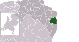
Vlagtwedde is a village in the very southeast of Groningen province in the northeastern Netherlands. It lies on the Dutch border with the German state of Lower Saxony to the east.
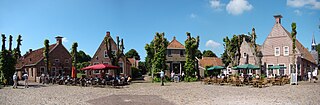
Bourtange is a village with a population of 430 in the municipality of Westerwolde in the Netherlands. It is situated in the region Westerwolde in the east of the province of Groningen near the German border. Fort Bourtange was built in 1593 during the Dutch Revolt and was used until 1851. Between 1967 and 1992 the star fort was gradually restored to its mid-18th-century state and it is currently an open-air museum.

Sellingen is a village in the Dutch province of Groningen. It is a part of the municipality of Westerwolde, and lies about 25 kilometres (16 mi) northeast of Emmen. In 2021, statistical area "Sellingen", which also includes the surrounding countryside, had a population of 1,880, and the village of Sellingen had 1,045.

Bellingwolde is a village with a population of 2,655 people in the municipality Westerwolde in the Netherlands. It is situated in the southeast of the region Oldambt, in the north of the region Westerwolde, and in the east of the province Groningen, at the border with Germany.

Wedde is a village in the municipality Westerwolde in the province Groningen in the Netherlands. It is located 9 km southeast of Winschoten. The castle Wedderborg is located in the village.

Den Ham is a hamlet in the Dutch province of Groningen. It is located in the municipality of Westerwolde, close to the border with Germany, between Bellingwolde and Nieuweschans.
Westerwolde is a region in the province Groningen in the north of the Netherlands. The region is located in the most eastern part of the Netherlands, alongside the German border. It is situated around the rivers Mussel Aa, Ruiten Aa, and Westerwoldse Aa, and it contains the villages Bellingwolde, Blijham, Onstwedde, Sellingen, Ter Apel, Vlagtwedde, Vriescheloo, and Wedde. The people in Westerwolde speak Dutch and the West Low German dialect Westerwolds.

Museum de Oude Wolden, abbreviated as MOW, is a regional museum in the village of Bellingwolde in the Netherlands. The museum focuses on art and history of the regions of Oldambt and Westerwolde in the east of the province of Groningen.

Oudeschans is a small village with a population of around 100 in the municipality of Westerwolde in the province of Groningen in the Netherlands. The 16th-century fortification is now a state protected village area with several national heritage sites, among which include a 17th-century garrison church, and the Vestingmuseum Oudeschans.

Blijham is a village with a population of 2,240 in the municipality of Westerwolde in the province of Groningen in the Netherlands. The origins of the settlement date back to the 11th century. Until 1968, Blijham was part of the municipality of Wedde. Until 2017, it was part of the municipality of Bellingwedde.

Veelerveen is a linear village with a population of around 720 in the municipality of Westerwolde in the Netherlands.
Rhederbrug is a hamlet near Bellingwolde in the municipality of Westerwolde in the Netherlands. The hamlet has a population of 240.

The Rechthuis is a former courthouse in the village of Bellingwolde in the Netherlands. The building with two crow-stepped gables was established in 1643 and used as a civil court for the area Bellingwolde-Blijham until 1811. The building has been a national heritage site since 1972. It is currently used as a private residence.

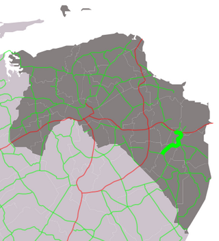
The N368 is a provincial road in the province of Groningen in the Netherlands. It runs from Blijham in the municipality of Westerwolde to Vlagtwedde in the same municipality.
The N367 is a provincial road in the province of Groningen in the Netherlands. It runs from Winschoten in the municipality of Oldambt to Nieuwe Pekela in the municipality of Pekela.
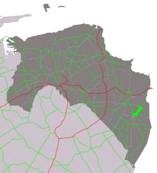
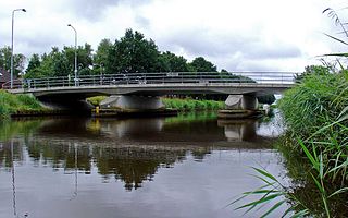
The N973 is a provincial road in the municipality of Westerwolde in the province of Groningen in the Netherlands. It runs from Wedde to Bellingwolde.

The coat of arms of Bellingwedde is an official symbol of the municipality of Bellingwedde in the province of Groningen in the Netherlands. It was officially adopted in 1969. The coat of arms consists of a crowned shield with blue, gold, and silver elements, which refer to the abbey Palmar and the Wedderborg.

Westerwolde is a municipality in the province of Groningen in the northeast of the Netherlands.