Related Research Articles

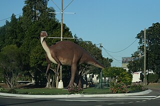
Winton is a town and locality in the Shire of Winton in Central West Queensland, Australia. It is 177 kilometres (110 mi) northwest of Longreach. The main industries of the area are sheep and cattle raising. The town was named in 1876 by postmaster Robert Allen, after his place of birth, Winton, Dorset. Winton was the first home of the airline Qantas.
Hughenden is a rural town and locality in the Flinders Shire, Queensland, Australia. In the 2016 census, the locality of Hughenden had a population of 1,136 people.

Richmond is a rural town and locality in the Shire of Richmond, Queensland, Australia. In the 2016 census, the locality of Richmond had a population of 648 people.

Nowy Łupków is a village in the administrative district of Gmina Komańcza, within Sanok County, Subcarpathian Voivodeship, in south-eastern Poland, close to the border with Slovakia. It lies approximately 11 kilometres (7 mi) south of Komańcza, 34 km (21 mi) south of Sanok, and 87 km (54 mi) south of the regional capital Rzeszów. The village has a population of 390.
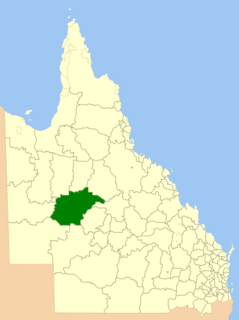
The Shire of Winton is a local government area in Central West Queensland, Australia. It covers an area of 53,814 square kilometres (20,777.7 sq mi), and has existed as a local government entity since 1887. Its administrative centre is located in the town of Winton. It is named after Winton, Dorset, England, the birthplace of Robert Allen, the first white settler in the Winton (Queensland) area.
Jindalee is a locality in the Riverina district of New South Wales, Australia. The Main South railway line passes through the area, and a passenger station was located there between 1896 and 1970. The town's name is derived from an aboriginal word meaning 'bare hill'.
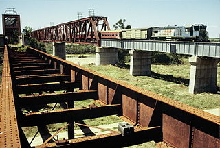
The Great Northern Railway is a 1,067 mm railway line in Queensland, Australia. The line stretches nearly 1,000 kilometres linking the port city of Townsville, Australia to the mining town of Mount Isa in north-west Queensland. Along with a passenger service called the Inlander, it is a major freight route connecting the Mount Isa Mines to the Port of Townsville. In 2010 the line moved 5.8 million tonnes of cargo, and this is expected to increase significantly in coming years.

Central West Queensland is a remote region in the Australian state of Queensland which covers 396 650.2 km2. The region lies to the north of South West Queensland and south of the Gulf Country. It has a population of approximately 12,387 people.

Prairie is a rural town and locality in the Flinders Shire, Queensland, Australia. In the 2016 census the locality of Prairie had a population of 143 people.

Stamford is a rural town and locality in the Shire of Flinders, Queensland, Australia. In the 2016 census, the locality of Stamford had a population of 43 people.

Corfield is a town and locality in the Shire of Winton in north-western Queensland, Australia. In the 2016 census, Corfield had a population of 183 people.

Middleton is a rural locality in the Shire of Winton, Queensland, Australia. In the 2016 census Middleton had a population of 9 people.

The Hughenden-Winton railway line was a railway line in Queensland, Australia, branching from the Mt Isa line at Hughenden and connecting to the Central West line at Winton.

Morella was a rural locality within Longreach Region, Queensland, Australia. Since January 2019, it has been amalgamated into the locality of Longreach.

The Central Western railway line is a railway line in Queensland, Australia. It was opened in a series of sections between 1867 and 1928. It commences at Rockhampton and extends west 863 kilometres (536 mi) to Winton.
Kabra is a rural town and locality in the Rockhampton Region, Queensland, Australia. In the 2016 census the locality of Kabra had a population of 421 people.
Collingwood is a former town in the Channel Country in Central West Queensland, Australia, in the Shire of Winton. Collingwood was founded in the 1870s, and it was hoped that the town would thrive and grow into a regional centre that would foster the development of pastoral activity in the Diamantina region, an industry of great local importance to this day. However, Collingwood ultimately failed as a town and was given up after only about two decades of existence.
Opalton is a rural locality in the Shire of Winton, Queensland, Australia. In the 2016 census Opalton had a population of 64 people. The Opalton township is located adjacent to the Opalton Opal Field, one of the largest and most extensively worked opal deposits in Queensland.
Marathon is a rural town and locality in the Flinders Shire, Queensland, Australia. Although the town has existed since circa 1916, the locality was created in November 2021.
Richmond–Winton Road is a continuous 145 kilometres (90 mi) road route in the Richmond and Winton local government areas of Queensland, Australia. It is a state-controlled district road rated as a local road of regional significance (LRRS). It is part of the shortest route from the Croydon / Georgetown area to Winton and Longreach. It is also part of the inland freight network linking cattle properties to major freight routes on the Landsborough and Flinders highways.
References
- ↑ "Prubi (entry 27588)". Queensland Place Names. Queensland Government . Retrieved 13 September 2015.
- ↑ "Queensland Globe". State of Queensland . Retrieved 27 July 2021.
- ↑ "Queensland Railway Nomenclature". The Queenslander. Brisbane. 11 April 1914. p. 8. Retrieved 1 October 2013.
Coordinates: 22°05′02″S143°07′53″E / 22.08389°S 143.13139°E
| | This Queensland location article is a stub. You can help Wikipedia by expanding it. |
| | This article about a railway station in Queensland is a stub. You can help Wikipedia by expanding it. |