Pruno (Cilento)

Last updated

Pruno
Pruno (di Laurino, view).jpg
View of Pruno di Laurino
Italy provincial location map 2016.svg
Red pog.svg
Pruno
Location of Pruno in Italy
Coordinates: 40°16′N15°24′E / 40.267°N 15.400°E / 40.267; 15.400 Coordinates: 40°16′N15°24′E / 40.267°N 15.400°E / 40.267; 15.400
CountryFlag of Italy.svg  Italy
Region Flag of Campania.svg  Campania
Province Coats of arms of None.svg Salerno (SA)
Comune Laurino-Stemma.jpg Laurino
Valle dell'Angelo-Stemma.jpg Valle dell'Angelo
Piaggine-Stemma.jpg Piaggine
Elevation
[1]
1,100 m (3,600 ft)
Population
  Total40
Demonym Prunesi
Time zone UTC+1 (CET)
  Summer (DST) UTC+2 (CEST)
Postal code
84057 (Laurino)
84070 (Valle dell'Angelo)
84065 (Piaggine)
Dialing code (+39) 0974
Panorama from the height of "Croce di Pruno" PRUNO (Panorama).JPG
Panorama from the height of "Croce di Pruno"

Pruno [2] is a forest in the Campania region of southern Italy. It is the largest woodlands of central Cilento region. The hamlets ( frazioni ) with this name are situated in the municipalities of Laurino, Valle dell'Angelo and Piaggine, and are considered a singular village.

Contents

Pruno represents one of the most unpolluted natural areas of Campania and one of the lesser inhabited territories of Southern Italy. It is protected within the Cilento and Vallo di Diano National Park, and is part of the Cilento World Heritage Site.

History

The area of Pruno has been inhabited for centuries by farmers. It had two periods of emigration during the end of 19th century and the second half of 20th.

Geography

Pruno is situated in south of the Province of Salerno, in the Cilento and Vallo di Diano National Park. The forest is located between Mount Gelbison and Mount Cervati mounts, at elevations between 600–1,300 metres (2,000–4,300 ft) above mean sea level.

The area is extended not only in the comunes of Valle dell'Angelo, Laurino and Piaggine; but also in Cannalonga, Campora, Rofrano, Sanza, Novi Velia and Monte San Giacomo; and is surrounded by other forest areas. The mountains of the areas are Vesalo, Monaco, Faiatella, Scanno del Tesoro, Raia del Pedale, and Tuzzi di Monte Piano. There are also the springs of Calore River, and some caves with prehistoric rock art.

The middle of the forest is known as Croce di Pruno (Cross of Pruno), a crossroad between the provincial road Piaggine-Rofrano (one of two completely covered with asphalt) and some trails, as the Inghiottitoio (Swallow), to Laurino / Campora (also covered with asphalt), and others to Cannalonga and San Menale. Major plains are the Piana of Roti and Campolongo.

Villages of Pruno

Population in the three rural villages of Pruno amounts almost in 40 inhabitants. It could be considered as a singular scattered village divided into 3 parts, for its common history and also due to a legislative singularity for Italian municipal law.

The villages of Pruno di Valle dell'Angelo and Pruno di Piaggine are situated in the municipal territory of Laurino, but these hamlets are not exclaves of their municipality. However their inhabitants have the citizenship of Valle and Piaggine, and ownership of their houses. [3] [4]

Pruno di Laurino

Pruno di Laurino ( 40°15′40″N15°24′17″E / 40.261147°N 15.404824°E / 40.261147; 15.404824 ), locally named simply Pruno, is situated along the Piaggine-Rofrano road, in south of the Croce di Pruno. It is composed by an extended group of circa 15 scattered farmhouses and populated by 25 people. Nearby the village there is a canyon with some little caves (Grotte di Sant'Elena) and the village was interested by the phenomena of the Brigandage in the Two Sicilies [5] in the first half of 19th century. It was in fact the headquarters for a band of brigands guided by Giuseppe Tardio. [6] It is the most populated side of Pruno and counts a rural school closed in 1960s and restored into 2000s as historical building. Its main road belongs to the municipality of Rofrano, consisting in a strip of territory. [7] For this reason the village is sometimes also named Pruno di Rofrano.

Pruno di Valle dell'Angelo

Pruno di Valle dell'Angelo ( 40°15′07″N15°23′45″E / 40.251993°N 15.395941°E / 40.251993; 15.395941 ), locally named Pruno Casalettaro, is a rural village, one of the last in Europe. It is located in a detour of Piaggine-Rofrano road, on a trail to Cannalonga and close to the canyon of Quarantana river. It is composed of circa 8 farmhouses and populated by 12–15 ancient people, with a rhythm of life similar to the one of 19th century, [8] where electrical energy was fasted only in 1992. The community, dedicated to animal husbandry and agriculture, is de facto autonomous and the village is indicated as a point of touristic interest. [9]

Pruno di Piaggine

Pruno di Piaggine ( 40°14′31″N15°23′23″E / 40.241929°N 15.389606°E / 40.241929; 15.389606 ), locally named Pruno Chiainaro, is the smallest of the three villages. It is situated on a trial from Pruno di Valle dell'Angelo to Rofrano via San Menale, below the trial to Cannalonga and nearby the canyon of Quarantana. It is composed by some scattered farmhouses and the population amounts of 10 inhabitants circa. A few km west it is the municipal border of Novi Velia, below the area of Gelbison mountain. [10]

See also

Related Research Articles

<span class="mw-page-title-main">Sanza, Campania</span> Comune in Campania, Italy

Sanza is a town and comune in the province of Salerno in the Campania region of southern Italy.

<span class="mw-page-title-main">Campora</span> Comune in Campania, Italy

Campora is a town and comune in the province of Salerno, Campania. It is located in the territory of Cilento and as of 2009 its population was 810.

<span class="mw-page-title-main">Casaletto Spartano</span> Comune in Campania, Italy

Casaletto Spartano is a town and comune in the province of Salerno in the Campania region of south-western Italy.

<span class="mw-page-title-main">Laurino</span> Comune in Campania, Italy

Laurino is a town and comune in the province of Salerno in the Campania region of southwestern Italy.

<span class="mw-page-title-main">Moio della Civitella</span> Comune in Campania, Italy

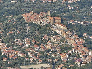
Moio della Civitella is a town and comune in the province of Salerno in the Campania region of south-western Italy.
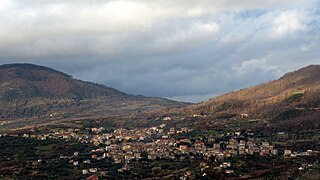
<span class="mw-page-title-main">Novi Velia</span> Comune in Campania, Italy

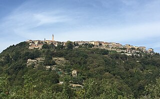
Novi Velia is a town and comune of the Province of Salerno, Campania, southern Italy. It is located in the southern Cilento area.

<span class="mw-page-title-main">Ogliastro Cilento</span> Comune in Campania, Italy

Ogliastro Cilento is a town and comune in the province of Salerno in the Campania region of south-western Italy. As of 2011 its population was of 2,241.

<span class="mw-page-title-main">Rofrano</span> Comune in Campania, Italy

Rofrano is a town and comune of the province of Salerno in the Campania region of south-west Italy. It is located in the southern Cilento. In 2015 its population was 1,539.

<span class="mw-page-title-main">Roscigno</span> Comune in Campania, Italy

Roscigno is a small town and comune in Salerno, Campania, Italy. It is located on the slope of Monte Pruno.

<span class="mw-page-title-main">Sacco, Campania</span> Comune in Campania, Italy

Sacco is a town and comune in the province of Salerno in the Campania region of south-western Italy. As of 2011, its population was 582.

<span class="mw-page-title-main">San Mauro Cilento</span> Comune in Campania, Italy

San Mauro Cilento is a town and comune in the province of Salerno in the Campania region of south-western Italy.

<span class="mw-page-title-main">Vallo della Lucania</span> Comune in Campania, Italy

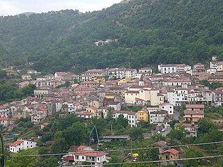
Vallo della Lucania is a town and comune in the province of Salerno in the Campania region of south-western Italy. It lies in the middle of Cilento and its population is 8,680.

<span class="mw-page-title-main">Torre Orsaia</span> Comune in Campania, Italy

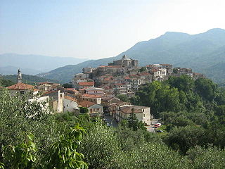
Torre Orsaia is a town and comune in the province of Salerno in the Campania region of south-western Italy.

<span class="mw-page-title-main">Santa Barbara, Ceraso</span> Frazione in Campania, Italy

Santa Barbara is an Italian village and hamlet (frazione) of the commune of Ceraso in the Province of Salerno, Campania. It has a population of roughly a thousand.

<span class="mw-page-title-main">Cilento</span> Geographical region in Italy

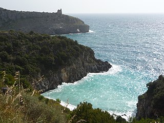
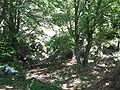
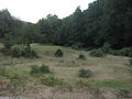
Cilento is an Italian geographical region of Campania in the central and southern part of the Province of Salerno and an important tourist area of southern Italy.

<span class="mw-page-title-main">Parco Nazionale del Cilento, Vallo di Diano e Alburni</span>

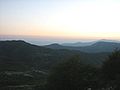
Cilento, Vallo di Diano and Alburni National Park is an Italian national park in the Province of Salerno, in Campania in southern Italy. It includes much of the Cilento, the Vallo di Diano and the Monti Alburni. It was founded in 1991, and was formerly known as the Parco Nazionale del Cilento e Vallo di Diano.

<span class="mw-page-title-main">Vallo di Diano</span> Valley in Salerno, Italy

The Vallo di Diano is an Italian valley of the south-eastern side of Campania, in the province of Salerno.

<span class="mw-page-title-main">Monte Gelbison</span> Mountain in Italy

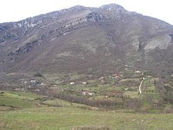
Gelbison is a mountain in the Lucan Subappennines range of the Apennine Mountains system, with an elevation of 1,705 metres (5,594 ft). It is located in the southern Cilento region of the Province of Salerno, in the Campania region, of southern Italy.

<span class="mw-page-title-main">Marina di Casalvelino</span> Frazione in Campania, Italy

Marina di Casalvelino, also spelled Casalvelino Marina, is a southern Italian village and hamlet (frazione) of Casal Velino, a municipality in the province of Salerno, Campania. With a population of 1,263 (2009), it is the most populated hamlet of its municipality.

<span class="mw-page-title-main">Ogliastro Marina</span> Frazione in Campania, Italy

Ogliastro Marina, sometimes shortened as Ogliastro, is a southern Italian village and hamlet (frazione) of Castellabate, a municipality in the province of Salerno, Campania. As of 2009 its population was of 172.

References

  1. Average elevation, from 600 to 1,300 amsl
  2. Name meaning the fruit of prunus tree in Cilentan dialect, which is "prugna" in italian
  3. (in Italian) Info on Luarino municipal site Archived 17 August 2007 at the Wayback Machine
  4. (in Italian) Info of Valle dell'Angelo municipal site Archived 21 October 2007 at the Wayback Machine
  5. (in Italian) Historical info on web page of Laurino Archived 27 September 2007 at the Wayback Machine
  6. (in Italian) Schedule about Giuseppe Tardio on brigantaggio.net
  7. 2495227175 Pruno di Laurino on OpenStreetMap
  8. (in Italian) Info on the web page of Valle dell'Angelo Archived 21 October 2007 at the Wayback Machine
  9. (in Italian) The natural environment of Pruno (la Città di Salerno)
  10. 2495227176 Pruno di Piaggine on OpenStreetMap