
The British Antarctic Territory (BAT) is a sector of Antarctica claimed by the United Kingdom as one of its 14 British Overseas Territories, of which it is by far the largest by area. It comprises the region south of 60°S latitude and between longitudes 20°W and 80°W, forming a wedge shape that extends to the South Pole, overlapped by the Antarctic claims of Argentina and Chile. The claim to the region has been suspended since the Antarctic Treaty came into force in 1961.

The South Orkney Islands are a group of islands in the Southern Ocean, about 604 km (375 mi) north-east of the tip of the Antarctic Peninsula and 844 km (524 mi) south-west of South Georgia Island. They have a total area of about 620 km2 (240 sq mi). The islands are claimed both by Britain, and by Argentina as part of Argentine Antarctica. Under the 1959 Antarctic Treaty, sovereignty claims are held in abeyance.

Clarence Island is the easternmost island in the South Shetland Islands, off the coast of Antarctica. It is claimed by Argentina as part of Argentine Antarctica, by Britain as part of the British Antarctic Territory, and by Chile as part of the Chilean Antarctic Territory. The name dates back to at least 1820 and is now established in international usage, except for Russia, where it has been known as Shishkova Island since its discovery by the First Russian Antarctic Expedition in 1821.

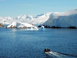
Palmer Archipelago, also known as Antarctic Archipelago, Archipiélago Palmer, Antarktiske Arkipel or Palmer Inseln, is a group of islands off the northwestern coast of the Antarctic Peninsula. It extends from Tower Island in the north to Anvers Island in the south. It is separated by the Gerlache and Bismarck straits from the Antarctic Peninsula and Wilhelm Archipelago, respectively. The archipelago is in the British, Chilean, and Argentine Claims.

Multiple governments have set up permanent research stations in Antarctica and these bases are widely distributed. Unlike the drifting ice stations set up in the Arctic, the current research stations of the Antarctic are constructed either on rocks or on ice that are fixed in place.

Snow Hill Island is an almost completely snowcapped island, 33 km (21 mi) long and 12 km (7.5 mi) wide, lying off the east coast of the Antarctic Peninsula. It is separated from James Ross Island to the north-east by Admiralty Sound and from Seymour Island to the north by Picnic Passage. It is one of several islands around the peninsula known as Graham Land, which is closer to Chile, Argentina and South America than any other part of the Antarctic continent.

Djerassi Glacier is a 2.8 km long and 1 km wide steep valley glacier situated south of Gorichane Glacier, west of the head of Malpighi Glacier, northwest of the head of Mackenzie Glacier, and north-northeast of Pirogov Glacier on Brabant Island in the Palmer Archipelago, Antarctica. It drains the west slopes of Harvey Heights and the north slopes of Mount Parry, and flows northwestwards into Lanusse Bay north of Venchan Bluff.
Pirogov Glacier is a 5 km long and 1.5 km wide glacier situated south of Djerassi Glacier, west of the head of Mackenzie Glacier and northwest of Balanstra Glacier on Brabant Island in the Palmer Archipelago, Antarctica. It drains the south-southwest slopes of Mount Parry and flows westwards to enter Dallmann Bay south of Minot Point.
Dimkov Glacier is a 6 km long and 4.3 km wide glacier draining the western slopes of Solvay Mountains on Brabant Island in the Palmer Archipelago, Antarctica. It is situated southwest of Rush Glacier and west of Jenner Glacier, and flows southwestwards between Kondolov Peak and Sheynovo Peak to enter Duperré Bay south of Humann Point.
Mitev Glacier is the 2.9 km (1.8 mi) long and 2.5 km (1.6 mi) wide glacier on Brabant Island in the Palmer Archipelago, Antarctica situated east of Laennec Glacier. It drains the north slopes of Avroleva Heights and flows northeastwards to enter Hill Bay west of Petroff Point.
Chumerna Glacier is the 2.2 km long and 1.9 km wide glacier draining the north slopes of Stavertsi Ridge on Albena Peninsula, Brabant Island in the Palmer Archipelago, Antarctica. It flows northeastwards to enter the channel between Brabant Island and Liège Island east of Hales Peak.

The Argentine Islands are a group of islands in the Wilhelm Archipelago of Antarctica, situated 9 km (5 nmi) southwest of Petermann Island, and 7 km (4 nmi) northwest of Cape Tuxen on Kyiv Peninsula in Graham Land. They were discovered by the French Antarctic Expedition, 1903–05, under Jean-Baptiste Charcot, and named by him for the Argentine Republic, in appreciation of that government's support of his expedition.
The Melchior Islands are a group of many low, ice-covered islands lying near the center of Dallmann Bay between Brabant Island and Anvers Island in the Palmer Archipelago, Antarctica. They were first seen but left unnamed by a German expedition under Eduard Dallmann, 1873–74. The islands were resighted and roughly charted by the Third French Antarctic Expedition under Jean-Baptiste Charcot, 1903–05.

Argentina Glacier is a glacier flowing northwest from Hurd Dome and terminating near Argentina Cove, South Bay, on Livingston Island, in the South Shetland Islands. The name Argentina Glacier was given in association with Argentina Cove by the Spanish Antarctic Expedition, about 1995.
Jenner Glacier is a glacier 3 nautical miles (6 km) long flowing southwest from the Solvay Mountains between Paprat Peak and Kondolov Peak into the eastern arm of Duperré Bay, in the southern part of Brabant Island in the Palmer Archipelago, Antarctica.
Koch Glacier is a glacier 3 nautical miles (6 km) long immediately east of Jenner Glacier on the south side of Brabant Island, in the Palmer Archipelago, Antarctica. It drains the south slopes of Solvay Mountains and flows south-southwestwards into Chiriguano Bay southeast of Paprat Peak.
Paré Glacier is a glacier 7 nautical miles (13 km) long and 1 nautical mile (1.9 km) wide, draining the northeast slopes of Stribog Mountains, and flowing east and then northeast into the head of Bouquet Bay on the northeast side of Brabant Island in the Palmer Archipelago, Antarctica.
Hippocrates Glacier is a glacier at least 3 nautical miles (6 km) long and 2 nautical miles (4 km) wide, draining the southeast slopes of Stribog Mountains and flowing southeast between Solvay Mountains and Gutsal Ridge into Buls Bay on the east side of Brabant Island, in the Palmer Archipelago, Antarctica. It was shown on an Argentine government chart in 1953, but not named. The glacier was photographed by Hunting Aerosurveys Ltd in 1956–57, and mapped from these photos in 1959. It was named by the UK Antarctic Place-Names Committee for Hippocrates, a Greek physician and author of numerous works on medicine, who also established a professional code of medical conduct.
Rush Glacier is a glacier in Antarctica. Situated in southern Brabant Island, it is 4 nautical miles (7 km) long, draining the northwest slopes of Solvay Mountains and flowing west between Mount Aciar and Mount Sarnegor into the Buragara Cove of Dallmann Bay in the Palmer Archipelago. It was shown on an Argentine government chart in 1953, but not named. It was photographed by Hunting Aerosurveys Ltd in 1956–57, and mapped from these photos in 1959. The glacier was named by the United Kingdom Antarctic Place-Names Committee (UK-APC) for Benjamin Rush (1745–1813), a noted American physician and philanthropist, and a signatory of the Declaration of Independence.
Lister Glacier is a glacier 5 nautical miles (9 km) long and 1 nautical mile (2 km) wide, draining the northeast slopes of Stribog Mountains and flowing into Bouquet Bay just south of Duclaux Point on the northeast side of Brabant Island, in the Palmer Archipelago, Antarctica.

