
Obsza is a village in Biłgoraj County, Lublin Voivodeship, in eastern Poland. It is the seat of the gmina called Gmina Obsza. It lies approximately 31 kilometres (19 mi) south-east of Biłgoraj and 108 km (67 mi) south of the regional capital Lublin.
Terpentyna is a village in the administrative district of Gmina Dzierzkowice, within Kraśnik County, Lublin Voivodeship, in eastern Poland. It lies approximately 11 kilometres (7 mi) north-west of Kraśnik and 47 km (29 mi) south-west of the regional capital Lublin. Terpentyna contains the gmina offices, although the designated seat (siedziba) of the gmina is Dzierzkowice, a location of which Terpentyna is now officially part.
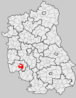
Księżomierz-Kolonia is a village in the administrative district of Gmina Gościeradów, within Kraśnik County, Lublin Voivodeship, in eastern Poland. It lies approximately 18 kilometres (11 mi) west of Kraśnik and 56 km (35 mi) south-west of the regional capital Lublin.
Liśnik Duży is a village in the administrative district of Gmina Gościeradów, within Kraśnik County, Lublin Voivodeship, in eastern Poland. It lies approximately 6 kilometres (4 mi) east of Gościeradów, 11 km (7 mi) west of Kraśnik, and 53 km (33 mi) south-west of the regional capital Lublin.
Marynopole is a village in the administrative district of Gmina Gościeradów, within Kraśnik County, Lublin Voivodeship, in eastern Poland. It lies approximately 7 kilometres (4 mi) east of Gościeradów, 12 km (7 mi) south-west of Kraśnik, and 56 km (35 mi) south-west of the regional capital Lublin.
Dąbrowa-Bór is a village in the administrative district of Gmina Kraśnik, within Kraśnik County, Lublin Voivodeship, in eastern Poland. It lies approximately 6 kilometres (4 mi) north of Kraśnik and 40 km (25 mi) south-west of the regional capital Lublin.
Karpiówka is a village in the administrative district of Gmina Kraśnik, within Kraśnik County, Lublin Voivodeship, in eastern Poland. It lies approximately 8 kilometres (5 mi) south-east of Kraśnik and 45 km (28 mi) south-west of the regional capital Lublin.

Kowalin is a village in the administrative district of Gmina Kraśnik, within Kraśnik County, Lublin Voivodeship, in eastern Poland. It lies approximately 6 kilometres (4 mi) west of Kraśnik and 49 km (30 mi) south-west of the regional capital Lublin.
Mikulin is a village in the administrative district of Gmina Kraśnik, within Kraśnik County, Lublin Voivodeship, in eastern Poland. It lies approximately 6 kilometres (4 mi) south-west of Kraśnik and 50 km (31 mi) south-west of the regional capital Lublin.
Pasieka is a village in the administrative district of Gmina Kraśnik, within Kraśnik County, Lublin Voivodeship, in eastern Poland. It lies approximately 2 kilometres (1 mi) east of Kraśnik and 44 km (27 mi) south-west of the regional capital Lublin.
Słodków Pierwszy is a village in the administrative district of Gmina Kraśnik, within Kraśnik County, Lublin Voivodeship, in eastern Poland. It lies approximately 4 kilometres (2 mi) south-east of Kraśnik and 45 km (28 mi) south-west of the regional capital Lublin.
Słodków Trzeci is a village in the administrative district of Gmina Kraśnik, within Kraśnik County, Lublin Voivodeship, in eastern Poland. It lies approximately 7 kilometres (4 mi) south-east of Kraśnik and 45 km (28 mi) south-west of the regional capital Lublin. In Słodków, there is source of Wyżnica, the right inflow of Wistula.
Spławy Drugie is a village in the administrative district of Gmina Kraśnik, within Kraśnik County, Lublin Voivodeship, in eastern Poland. It lies approximately 5 kilometres (3 mi) west of Kraśnik and 48 km (30 mi) south-west of the regional capital Lublin.
Spławy Pierwsze is a village in the administrative district of Gmina Kraśnik, within Kraśnik County, Lublin Voivodeship, in eastern Poland. It lies approximately 3 kilometres (2 mi) west of Kraśnik and 46 km (29 mi) south-west of the regional capital Lublin.
Stróża-Kolonia is a village in the administrative district of Gmina Kraśnik, within Kraśnik County, Lublin Voivodeship, in eastern Poland. It lies approximately 6 kilometres (4 mi) east of Kraśnik and 44 km (27 mi) south-west of the regional capital Lublin.
Suchynia is a village in the administrative district of Gmina Kraśnik, within Kraśnik County, Lublin Voivodeship, in eastern Poland. It lies approximately 3 kilometres (2 mi) north-west of Kraśnik and 44 km (27 mi) south-west of the regional capital Lublin.
Dębowiec is a village in the administrative district of Gmina Trzydnik Duży, within Kraśnik County, Lublin Voivodeship, in eastern Poland. It lies approximately 4 kilometres (2 mi) north of Trzydnik Duży, 7 km (4 mi) west of Kraśnik, and 50 km (31 mi) south-west of the regional capital Lublin.
Łychów Szlachecki is a village in the administrative district of Gmina Trzydnik Duży, within Kraśnik County, Lublin Voivodeship, in eastern Poland. It lies approximately 6 kilometres (4 mi) south of Trzydnik Duży, 13 km (8 mi) south-west of Kraśnik, and 57 km (35 mi) south-west of the regional capital Lublin.
Kajetanówka is a village in the administrative district of Gmina Urzędów, within Kraśnik County, Lublin Voivodeship, in eastern Poland. It lies approximately 2 kilometres (1 mi) south-east of Urzędów, 8 km (5 mi) north-west of Kraśnik, and 41 km (25 mi) south-west of the regional capital Lublin.
Sulów is a village in the administrative district of Gmina Zakrzówek, within Kraśnik County, Lublin Voivodeship, in eastern Poland. It lies approximately 8 kilometres (5 mi) east of Kraśnik and 41 km (25 mi) south-west of the regional capital Lublin.


