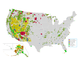
Map of all federally owned land in the United States.Most of the public land managed by the US Forest Service and Bureau of Land Management is in the Western states. Public lands account for 25 to 75 percent of the total land area in these states.The US Forest Service alone manages 193 million acres (780,000 km²) nationwide, or roughly 8% of the total land area in the United States.
In the United States, governmental entities at all levels- including townships, cities, counties, states, and the federal government- all manage land which are referred to as either public lands or the public domain.
In general, Congress must legislate the creation or acquisition of new public lands, such as national parks; however, under the 1906 Antiquities Act, also known as the National Monuments Act, the president may designate new national monuments without congressional authorization if the monument is on federally-owned land.
Each western state also received federal "public land" as trust lands designated for specific beneficiaries, which the States are to manage as a condition to acceptance into the union. Those trust lands cannot any longer be considered public lands as allowing any benefits to the "public" would be in breach of loyalty to the specific beneficiaries. The trust lands (two sections, or about 1,280 acres (5.2km2) per township) are usually managed extractively (grazing or mining), to provide revenue for public schools. All states have some lands under state management, such as state parks, state wildlife management areas, and state forests.
Typically each parcel is governed by its own set of laws and rules that explain the purpose for which the land was acquired, and how the land may be used.
Most state- and federally managed public lands are open for recreational use. Recreation opportunities depend on the managing agency, and run the gamut from the less restrictive, undeveloped wide open spaces of BLM lands to the highly developed and controlled national and state parks. Wildlife refuges and state wildlife management areas, managed primarily to improve habitat, are generally open to wildlife watching, hiking, and hunting, except for closures to protect mating and nesting, or to reduce stress on wintering animals. National forests generally have a mix of maintained trails and roads, wilderness and undeveloped portions, and developed picnic and camping areas.
Cattle and sheep grazing
Historically in the western United States, much public land is leased for grazing by cattle or sheep (most National Park Service areas are closed to livestock grazing). This includes vast tracts of National Forest and BLM land, as well as land on some Wildlife Refuges. National Parks are the exception. This use became controversial in the late 20th century as it was examined by environmentalists and scientists concerned about the impact of these exotic animals on native plant populations and watersheds.[5]
Oil and gas drilling and mining
Large tracts of public land in the United States are available for leasing for petroleum or mineral production. Lands which have a high likelihood of producing valuable resources can, as of 2018, command prices as high as $80,000 an acre per year. Large tracts of other lands, where the likelihood of the presence or successful exploitation of resources are very low, could be leased, as of 2018, for as low as $1.50 an acre per year. The Trump administration greatly expanded mineral leasing resulting in a substantial increase in fracking in likely locations in Wyoming and New Mexico,[6] but a great deal of land where prospects for successful production were limited was leased at very low rates to speculators.[7]
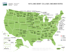
A land-grant university (also called land-grant college or land-grant institution) is an institution of higher education in the United States designated by a state to receive the benefits of the Morrill Acts of 1862 and 1890,[8] or a beneficiary under the Equity in Educational Land-Grant Status Act of 1994.[9] There are 57 institutions which fall under the 1862 Act, 19 under the 1890 Act, and 35 under the 1994 Act.
Signed by President Abraham Lincoln in 1862, the first Morrill Act began to fund educational institutions by granting federally owned land to the states for them to sell, to raise funds, to establish and endow "land-grant" colleges. The mission of these institutions as set forth in the 1862 act is to focus on the teaching of practical agriculture, science, military science, and engineering—although "without excluding other scientific and classical studies".[10]
his mission was in sharp contrast to the historic practice of higher education concentrating entirely on a liberal arts curriculum based largely on Latin and Greek. The 1890 act required states that limited the enrollment in their land-grant school to the "white race" (in practice mostly those in the Southern United States) to provide a separate land-grant institution, in practice generally for African Americans (HBCUs). The 1994 expansion gave land-grant status and benefits to several tribal colleges and universities.[9]
The sale of public lands made possible the very rapid settlement of Nebraska. Railroads played a central role.[12] The land was good for farms and ranches, but without transportation would be impossible to raise commercial crops. The railroad companies had been given large federal land grants that were used to back the borrowings from New York and London that financed construction. They were anxious to locate settlers upon the land as soon as possible, ensuring there would be a steady outflow of farm products and a steady inflow of manufactured items purchased by the farmers. Railroads like Union Pacific also built towns that were needed to service the railroad itself, with dining halls for passengers, construction crews, repair shops and housing for train crews. These towns attracted cattle drives and cowboys.[13][14]
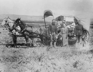
In the 1870s and 1880s Civil War veterans and immigrants from Northern Europe came by the thousands to take up land in Nebraska. The immigrants rapidly pushed westward the frontier line of settlement despite severe droughts, grasshopper plagues, economic distress, and other harsh conditions confronting the new settlers. Most of the great cattle ranches that had grown up near the ends of the trails from Texas gave way to farms, although the Sand Hills remained essentially a ranching country.
A land offer from the Burlington and Missouri River Railroad, 1872
The Union Pacific (UP) land grant gave it ownership of 12,800 acres per mile of finished track. The federal government kept every other section of land, rendering a surplus of 12,800 acres to sell or give away to homesteaders. The UP's goal was not to make a profit, but rather to build up a permanent clientele of farmers and townspeople who would form a solid basis for routine sales and purchases. The UP, like other major lines, opened sales offices in the East and in Europe to advertise their lands heavily far away and abroad,[15] offering attractive package rates for migrant farmers to sell out and moved their entire family and necessary agricultural tools to the new destination. In 1870 the UP sold rich Nebraska farmland at five dollars an acre, with one fourth down and the remainder in three annual installments. It gave a 10 percent discount for cash.[16] Farmers could also homestead land, getting it free from the federal government after five years, or even sooner by paying $1.50 an acre. Sales were improved by offering large blocks to ethnic colonies of European immigrants. Germans and Scandinavians, for example, could sell out their small farm back home and buy much larger farms for the same money. European ethnics comprised half of the population of Nebraska in the late 19th century.[17] Married couples were usually the homesteaders, but single women were also eligible on their own.[18]
A typical development program was that undertaken by the Burlington and Missouri River Railroad to promote settlement in southeastern Nebraska during 1870–80. The company participated enthusiastically in the boosterism campaigns that drew optimistic settlers to the state. The railroad offered farmers the opportunity to purchase land grant parcels on easy credit terms. Soil quality, topography, and distance from the railroad line generally determined railroad land prices. Immigrants and native-born migrants sometimes clustered in ethnic-based communities, but mostly the settlement of railroad land was by diverse mixtures of migrants. By deliberate campaigns, land sales, and a vast transportation network, the railroads facilitated and accelerated the peopling and development of the Great Plains, with railroads and water key to the potential for success in the Plains environment.[19]
Pursuant to the Property Clause of the United States Constitution (Article 4, section 3, clause 2), Congress has the power to retain, buy, sell, and regulate federal lands, such as by limiting cattle grazing on them. These powers have been recognized in a long series of United States Supreme Court decisions.[20][21]
In Article I, Section 8, Clause 17 the United States Constitution empowers the federal government with exclusive legislative authority like that exercised for Washington D.C. over "Places purchased by the Consent of the Legislature of the State in which the same shall be, for the erection of Forts, Magazines, Arsenals, Dock-yards, and other needful Buildings."[22]
Wilderness is a special designation for public lands which have been completely undeveloped. The concept of wilderness areas was legislatively defined by the 1964 Wilderness Act. Wilderness areas can be managed by any of the above Federal agencies, and some parks and refuges are almost entirely designated wilderness. A wilderness study area is a tract of land that has wilderness characteristics, and is managed as wilderness, but has not received a wilderness designation from Congress.[23]
↑ Carol Hardy Vincent et al. "Federal Land Ownership: Acquisition and Disposal Authorities" (Congressional Research Service, 2023) online; not copyright
↑ "Federal Land Ownership: Overview and Data" (Congressional Research Service, 2020) online
↑ Pages 14-73, "The Public Lands Debate", Sharman Apt Russell, Kill the Cowboy: A Battle of Mythology in the New West, Addison-Wesley (May, 1993), hardcover, 218 pages, ISBN0-201-58123-X
↑ Robert G. Athearn, Union Pacific Country (1971).
↑ David F Halass, Hell on Wheels: Wicked Towns Along the Union Pacific Railroad (2013)
↑ John C. Hudson, "Towns of the western railroads." Great Plains Quarterly 2#1 (1982): 41-54. online
↑ Charlyne Berens and Nancy Mitchell, "Parallel Tracks, Same Terminus: The Role of Nineteenth-Century Newspapers and Railroads in the Settlement of Nebraska." Great Plains Quarterly (2009): 287-300. online
↑ Gilbert C. Fite, The Farmers' Frontier, 1865-1900 (1966) pp 16-17, 31-33.
↑ Frederick C. Luebke, "Ethnic group settlement on the Great Plains." Western Historical Quarterly 8#4 (1977): 405-430. in JSTOR
↑ Sheryll Patterson-Black, "Women homesteaders on the Great Plains frontier." Frontiers: A Journal of Women Studies (1976): 67-88. in JSTOR
↑ Kurt E. Kinbacher, and William G. Thoms III, "Shaping Nebraska", Great Plains Quarterly, Summer 2008, Vol. 28 Issue 3, pp. 191–207.
↑ Paul Rodgers, United States Constitutional Law: An Introduction (2011), p. 100-101.
↑ Gibson v. Chouteau, 80 U.S. 92, 99 (1872), U.S. v. Grimaud, 220 U.S. 506 (1911), Light v. U.S. 220 U.S. 523 (1911), Utah Power & Light Co. v. U.S., 243 U.S. 389, 405 (1917), Ashwander v. Tennessee Valley Authority, 297 U.S. 288, 336 (1936).
↑ Cornell University Law School, , Cornell University Legal Information Institute]
↑ Sean Kammer, "Coming to terms with wilderness: The Wilderness Act and the problem of wildlife restoration." Environmental Law (2013): 83-124. online
Further reading
Bates, R. M. "Government by Improvisation? Towards a New History of the Nineteenth-Century American State." Journal of Policy History 33.3 (2021): 287-316. Considers how they handled state lands.
Cai M, I. Murtazashvili, J. Murtazashvili). "The politics of land property rights" Journal of Institutional Economics (2020) 16:151–167. online, compare USA with China and Afghanistan
Carlos, Ann M., Donna L. Feir, and Angela Redish. "Indigenous nations and the development of the US economy: Land, resources, and dispossession." Journal of Economic History 82.2 (2022): 516-555. online
Cox, Thomas R., et al. This well-wooded land: Americans and their forests from colonial times to the present (U of Nebraska Press, 1985)
Daniels, Thomas L., and Daniel Moscovici. "Protected Land Management and Governance in the United States: More Than 150 Years of Change." Society & Natural Resources 33.6 (2020): 711-720.
Dick, Everett. The lure of the land: A social history of the public lands from the Articles of Confederation to the New Deal (U of Nebraska Press, 1970) online
Gates, Paul Wallace. History of public land law development (US Government Printing Office, 1968). online
Hibbard, Benjamin Horace. A history of the public land policies (1924) online
Kammer, Sean. "Coming to terms with wilderness: The Wilderness Act and the problem of wildlife restoration." Environmental Law (2013): 83-124. online
Ten Brook, Andrew. American State Universities, Their Origin and Progress; a History of Congressional University Land-grants (1875). online
Wellington, Raynor Greenleaf. The political and sectional influence of the public lands, 1828-1842 (1914), based on PhD dissertation directed by Frederick Jackson Turneronline
Wilson, Randall K. America's Public Lands: From Yellowstone to Smokey Bear and Beyond (Rowman & Littlefield, 2014).
Wishart, David J. ed. Encyclopedia of the Great Plains (2004) online
Related Research Articles
The Great Plains are a broad expanse of flatland in North America. The region is located just to the east of the Rocky Mountains, much of it covered in prairie, steppe, and grassland. They are the western part of the Interior Plains, which include the mixed grass prairie, the tallgrass prairie between the Great Lakes and Appalachian Plateau, and the Taiga Plains and Boreal Plains ecozones in Northern Canada. "Great Plains", or Western Plains, is also the ecoregion of the Great Plains or alternatively the western portion of the Great Plains.
The Bureau of Land Management (BLM) is an agency within the United States Department of the Interior responsible for administering U.S. federal lands. Headquartered in Washington, D.C., the BLM oversees more than 247.3 million acres (1,001,000 km2) of land, or one-eighth of the United States's total landmass.
The Homestead Acts were several laws in the United States by which an applicant could acquire ownership of government land or the public domain, typically called a homestead. In all, more than 160 million acres of public land, or nearly 10 percent of the total area of the United States, were given away free to 1.6 million homesteaders; most of the homesteads were west of the Mississippi River. These acts were the first sovereign decisions of post-war North–South capitalist cooperation in the United States.
In all modern states, a portion of land is held by central or local governments. This is called public land, state land, or Crown land. The system of tenure of public land, and the terminology used, varies between countries. The following examples illustrate some of the range.
The protected areas of the United States are managed by an array of different federal, state, tribal and local level authorities and receive widely varying levels of protection. Some areas are managed as wilderness, while others are operated with acceptable commercial exploitation. As of 2022, the 42,826 protected areas covered 1,235,486 km2 (477,024 sq mi), or 13 percent of the land area of the United States. This is also one-tenth of the protected land area of the world. The U.S. also had a total of 871 National Marine Protected Areas, covering an additional 1,240,000 sq mi (3,200,000 km2), or 26 percent of the total marine area of the United States.
The protected areas of Michigan come in an array of different types and levels of protection. Michigan has five units of the National Park Service system. There are 14 federal wilderness areas; the majority of these are also tribal-designated wildernesses. It has one of the largest state forest systems as well having four national forests. The state maintains a large state park system and there are also regional parks, and county, township and city parks. Still other parks on land and in the Great Lakes are maintained by other governmental bodies. Private protected areas also exist in the state, mainly lands owned by land conservancies.
The Sagebrush Rebellion was a movement in the Western United States in the 1970s and the 1980s that sought major changes to federal land control, use, and disposal policy in 13 western states in which federal land holdings include between 20% and 85% of a state's area. Supporters of the movement wanted more state and local control over the lands, if not outright transfer of them to state and local authorities and/or privatization. As much of the land in question is sagebrush steppe, supporters adopted the name "Sagebrush Rebellion."
Federal lands are lands in the United States owned and managed by the federal government. Pursuant to the Property Clause of the United States Constitution, Congress has the power to retain, buy, sell, and regulate federal lands, such as by limiting cattle grazing on them. These powers have been recognized in a long series of United States Supreme Court decisions.
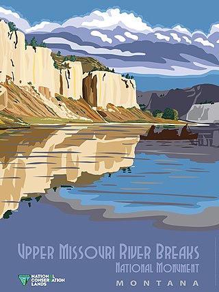
The Upper Missouri River Breaks National Monument is a national monument in the western United States, protecting the Missouri Breaks of north central Montana. Managed by the Bureau of Land Management (BLM), it is a series of badland areas characterized by rock outcroppings, steep bluffs, and grassy plains; a topography referred to as "The Breaks".
The question of whether to drill for oil in the Arctic National Wildlife Refuge (ANWR) has been an ongoing political controversy in the United States since 1977. As of 2017, Republicans have attempted to allow drilling in ANWR almost fifty times, finally being successful with the passage of the Tax Cuts and Jobs Act of 2017.
The Charles M. Russell National Wildlife Refuge is a National Wildlife Refuge in the U.S. state of Montana on the Missouri River. The refuge surrounds Fort Peck Reservoir and is 915,814 acres (3,706.17 km2) in size. It is the second-largest National Wildlife Refuge in the lower 48 states of the United States, and the largest in Montana. Created in 1936, it was originally called the Fort Peck Game Range. It was renamed in 1963 after Montana artist Charles M. Russell, a famous painter of the American West. In 1976, the "range" was made a "refuge".
The Nebraska National Forest is a United States National Forest located within the U.S. state of Nebraska. The total area of the national forest is 141,864 acres, or 222 sq miles (574 km2). The forest is managed by the U.S. Forest Service's Nebraska Forests and Grasslands Supervisor's Office in Chadron, Nebraska. The national forest includes two ranger districts, the Bessey Ranger District and the Pine Ridge Ranger District. In descending order of land, the forest lies in parts of Thomas, Dawes, Blaine, and Sioux counties.
The Great Sioux Reservation was an Indian reservation created by the United States through treaty with the Sioux, principally the Lakota, who dominated the territory before its establishment. In the Fort Laramie Treaty of 1868, the reservation included lands west of the Missouri River in South Dakota and Nebraska, including all of present-day western South Dakota. The treaty also provided rights to roam and hunt in contiguous areas of North Dakota, Montana, Wyoming, and northeast Colorado.
The National Wilderness Preservation System (NWPS) of the United States protects federally managed wilderness areas designated for preservation in their natural condition. Activity on formally designated wilderness areas is coordinated by the National Wilderness Preservation System. Wilderness areas are managed by four federal land management agencies: the National Park Service, the U.S. Forest Service, the U.S. Fish and Wildlife Service, and the Bureau of Land Management.
National Conservation Lands, formally known as the National Landscape Conservation System, is a 35-million-acre (140,000 km2) collection of lands in 873 federally recognized areas considered to be the crown jewels of the American West. These lands represent 10% of the 258 million acres (1,040,000 km2) managed by the Bureau of Land Management (BLM). The BLM is the largest federal public land manager and is responsible for over 40% of all the federal public land in the nation. The other major federal public land managers include the US Forest Service (USFS), National Park Service (NPS), and the US Fish and Wildlife Service (USFWS).
The Wilderness Society is an American non-profit land conservation organization that is dedicated to protecting natural areas and federal public lands in the United States. They advocate for the designation of federal wilderness areas and other protective designations, such as for national monuments. They support balanced uses of public lands, and advocate for federal politicians to enact various land conservation and balanced land use proposals. The Wilderness Society also engages in a number of ancillary activities, including education and outreach, and hosts one of the most valuable collections of Ansel Adams photographs at their headquarters in Washington, D.C.
The history of the U.S. state of Nebraska dates back to its formation as a territory by the Kansas–Nebraska Act, passed by the United States Congress on May 30, 1854. The Nebraska Territory was settled extensively under the Homestead Act of 1862 during the 1860s, and in 1867 was admitted to the Union as the 37th U.S. state. The Plains Indians are the descendants of a long line of succeeding cultures of indigenous peoples in Nebraska who occupied the area for thousands of years before European arrival and continue to do so today.
The Omnibus Public Land Management Act of 2009 is a land management law passed in the 111th United States Congress and signed into law by President Barack Obama on March 30, 2009. The bill designates millions of acres in the US as protected and establishes a National Landscape Conservation System. It includes funding for programs, studies and other activities by the Department of the Interior and the Department of Agriculture, and in some cases bars further geothermal leasing, oil and gas leasing, and new mining patents on certain stretches of protected land.
This page is based on this Wikipedia article Text is available under the CC BY-SA 4.0 license; additional terms may apply. Images, videos and audio are available under their respective licenses.