The Futaleufú River, located in northern Patagonia, is one of two rivers that cross the 5,308 kilometres (3,298 mi) Argentina–Chile border. Its headwaters can be found in the glacial snow melt of the UNESCO protected Los Alerces National Park in Argentina. The river gorge drops as low as 1,700 metres (5,600 ft) below the surrounding glaciated peaks. The name Futaleufú is an indigenous Mapuche word meaning "Big River". Locals refer to the valley as "un paisaje pintado por Dios" — a landscape painted by God.
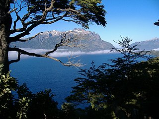
Los Alerces National Park is located in the Andes in Chubut Province in the Patagonian region of Argentina. Its western boundary coincides with the Chilean border. Successive glaciations have molded the landscape in the region creating spectacular features such as moraines, glacial cirques and clear-water lakes. The vegetation is dominated by dense temperate forests, which give way to alpine meadows higher up under the rocky Andean peaks. A highly distinctive and emblematic feature is its alerce forest; the globally threatened alerce tree is the second longest living tree species in the world. The alerce forests in the park are in an excellent state of conservation. The property is vital for the protection of some of the last portions of continuous Patagonian Forest in an almost pristine state and is the habitat for a number of endemic and threatened species of flora and fauna.

The Lago Puelo National Park is a national park of Argentina, located in the northwest of the province of Chubut, in the Patagonia region of South America. It has an area of 276.74 square kilometres. It was created to protect its scenic landscape and the Valdivian flora to augment that of the nearby Los Alerces National Park. Originally an annex to Los Alerces, it was declared a National Park and independent reserve in 1971.

The Los Ríos Region is one of Chile's 16 regions, the country's first-order administrative divisions. Its capital is Valdivia. It began to operate as a region on October 2, 2007, having been created by subdividing the Los Lagos Region in southern Chile. It consists of two provinces: Valdivia and the newly created Ranco Province, which was formerly part of Valdivia Province.
Huechulafquen Lake is a lake in Neuquén Province, Patagonian Argentina. This glacial lake is located in the Andean mountains in Lanín National Park some 25 kilometres from Junín de los Andes and 60 kilometres from San Martín de los Andes. It is one of Argentina's largest Andean lakes and is fed by glaciers and meltwater streams and lakes.

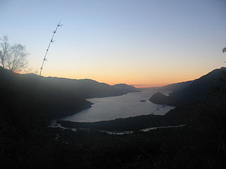
General Carrera Lake or Lake Buenos Aires is a deep lake located in Patagonia and shared by Argentina and Chile. Both names are internationally accepted, while the autochthonous name of the lake is Chelenko, which means "stormy waters" in Aonikenk. Another historical name is Coluguape from Mapuche, a derivative of this name is applied to Colhué Huapí Lake after Argentine explorer Francisco Moreno reached this lake in 1876 conflating it with Coluguape.
Junín de los Andes is a first category municipality and administrative center of the Huiliches Department in the province of Neuquén, Argentina. It is located in the south of the province, by the Chimehuin River, on National Route 234, about 35 km (22 mi) north of San Martín de los Andes and 17 km (11 mi) from the Chapelco Airport, which services the area.

The Puelo River has its origin in Lake Puelo in Argentine, and flows north-west through the Andes into Chile and the Reloncaví Estuary of the Reloncaví Sound at the northern end of the Gulf of Ancud.

Panguipulli is a city and commune in Valdivia Province, southern Chile, administered by the Municipality of Panguipulli. It is located on the western edge of Panguipulli Lake, and is on a moraine in the Chilean Central Valley. Most of the commune lies on Andean mountains and valleys.
The Riñihue Lake is a lake of glacial origin in eastern Valdivia Province, southern Chile. It is surrounded by several mountains. The eastern side receives the waters of the Panguipulli Lake by the Enco River, its main contributor. It is the last of the Seven Lakes chain. In the west it is cut into two arms by the Tralcán Mount, and on the east side lies the Mocho-Choshuenco volcano. In the south the lake is bounded by the Cerros de Quimán mountains.

Aluminé Lake is a large and deep lake located in the Andes in the western part of Neuquén Province, Argentina, near the border with Chile. Aluminé Lake is fed by the outflow of Lake Moquehue and is the source of the Aluminé River whose waters ultimately reach the Atlantic Ocean. The tourist town of Villa Pehuenia is on the northern shore of the lake.
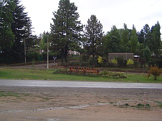
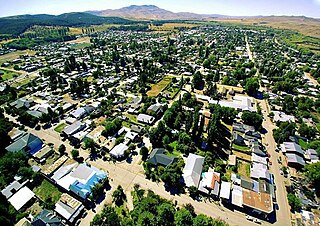
Aluminé is a second class municipality and the capital city of Aluminé Department located in the west-central part of the Neuquén Province, Argentina. With an economy based on animal husbandry, forest exploitation and tourism, it serves as a service center for the nearby rural areas.
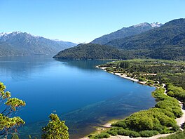
Futalaufquen Lake is a large lake in Chubut Province, Argentina. Futalaufquen Lake is in the chain of lakes of the Futaleufú River system of Argentina which via Yelcho Lake and the Yelcho River flows into the Pacific Ocean in Chile. Located in the Andes, Lake Futalaufquen is three-lobed, of glacial origin, and occupies narrow valleys between glaciated peaks. It is located in the Andes within Los Alerces National Park. The name comes from the Mapuche language. "Futa" means great, and "laufquen" means lake.

The Manso River is a river of Rio Negro Province of Argentina and Los Lagos Region of Chile, both part of Patagonia. The Manso River is located in the Andes. It follows a winding route through snow-capped mountains and connects many glacial lakes. The Manso flows generally southward until its confluence with the Puelo River in Chile. The river while in Argentina flows through the Nahuel Huapi National Park. Most of the southern part of Nahuel Huapi is in the drainage basin of the Manso River.
Villa Pehuenia is a village and municipality in Neuquén Province in southwestern Argentina. The town is located on the northern shore of Aluminé Lake and its economy is primarily based on tourism. The village is in the Andes and is located about 10 kilometres (6.2 mi) from the border with Chile via a highway through the Icalma pass. The town is named after the pehuén or monkey puzzle tree, an endangered species found here at the southernmost limit of its range.

Nahuel Huapi National Park is the oldest national park in Argentina, established in 1922 as Parque Nacional de Sud and reconfiguered in 1934. It surrounds Nahuel Huapi Lake in the foothills of the Patagonian Andes. The largest of the national parks in the region, it has an area of 7,050 km2 (2,720 sq mi), or nearly 2 million acres. Its landscapes represent the north Patagonian Andean Zone consisting of three types, namely, the Altoandino, the Andino-Patagónico and the Patagonian steppe. It also represents small parts of the Valdivian Rainforest.

Mascardi Lake is in the lake region of northern Patagonia in Río Negro Province of Argentina. The lake is near the resort city of Bariloche and is within the Nahuel Huapi National Park. The lake, of glacial origin, is named after Nicolás Mascardi, a 17th-century Jesuit who was a missionary in the area.

Lake Cholila is a lake in Chubut Province, Argentina. Lake Cholila is the uppermost of several large lakes in the Futaleufú River system of Argentina that via Yelcho Lake and the Yelcho River flows into the Pacific Ocean in Chile. The lake is of glacial origin and occupies a narrow east to west valley between glaciated peaks of the Andes.

Lake Rivadavia is a lake in Chubut Province, Argentina. Lake Rivadavia is the second lake, after Lake Cholila, in the chain of lakes in the Futaleufú River system of Argentina which via Yelcho Lake and the Yelcho River flows into the Pacific Ocean in Chile. Located in the Andes, Lake Rivadavia is of glacial origin and occupies a narrow north to south valley between glaciated peaks. All the lake except the northern tip is in the Los Alerces National Park. Argentina Provincial Highway 71 follows the eastern coast of the lake. Development consists only of a few campgrounds near the highway.

Lake Menéndez is a large lake in Chubut Province, Argentina. Lake Menéndez is in the chain of lakes in the Futaleufú River system of Argentina which via Yelcho Lake and the Yelcho River flows into the Pacific Ocean in Chile. Located in the Andes, Lake Menendez is Y-shaped, of glacial origin, and occupies two narrow valleys between glaciated peaks. The lake is in the Los Alerces National Park. There are no roads or other developments near the lake. Travel is by boat or foot. Lake Menéndez is noted for the extensive Alerce (Fitzroya) forests near the tips of its two arms.