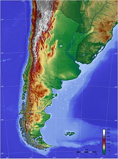
The geography of Argentina describes the geographic features of Argentina, a country located in Southern South America. Bordered by the Andes in the west and the South Atlantic Ocean to the east, neighbouring countries are Chile to the west, Bolivia and Paraguay to the north, and Brazil and Uruguay to the northeast.

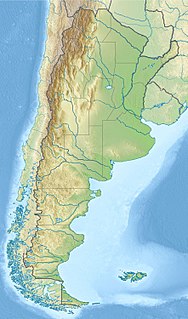
Santa Cruz Province is a province of Argentina, located in the southern part of the country, in Patagonia. It borders Chubut Province to the north, and Chile to the west and south, with an Atlantic coast on its east. Santa Cruz is the second-largest province of the country, and the least densely populated in mainland Argentina.

Futaleufú is a department in the north west of Chubut Province, Argentina. Its main town and capital is Esquel to the north, with Trevelin and El Corcovado as the only other towns of significant size. Other settlements are Cerro Centinela, Aldea Escolar, Los Cipreses and Lago Rosario. The population of the department is 37,500 inhabitants as per the 2001 census [INDEC], which represents a population density of fewer than 4 inhabitants/km2.

Lago Argentino is a lake in the Patagonian province of Santa Cruz, Argentina, at 50°2′S72°4′W. It is the biggest freshwater lake in Argentina, with a surface area of 1,415 km2 (546 sq mi). It has an average depth of 150 m (492 ft), and a maximum depth of 500 m (1,640 ft).

El Calafate is a city in Patagonia, Argentina. It is situated on the southern border of Lake Argentino, in the southwest part of the Santa Cruz Province, about 320 kilometres (200 mi) northwest of Río Gallegos. The name of the city is derived from a little bush with yellow flowers and dark blue berries that is very common in Patagonia: the calafate ; the word comes from the word calafate, which is Spanish for 'caulk'.

The Road of the Seven Lakes is the popular name given to the scenic portion of national route 40 between the towns of San Martín de los Andes and Villa La Angostura in the Neuquén Province, in Patagonia Argentina.

The Aónikenk people, also referred to by the exonym Tehuelche, are an indigenous people from Patagonia in South America, with existing members of the group currently residing in the southern Argentina-Chile borders.
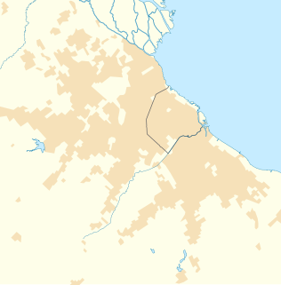
Chapinero is the 2nd locality of Bogotá, capital of Colombia. It is located in the north of the city and is one of the more affluent districts of the city. This district is mostly inhabited by upper class residents. The boundaries are Calle 39 in the south, Avenida Caracas in the west, Calle 100 in the north and the Eastern Hills in the east.
Tigre is a city in the Buenos Aires Province, Argentina, situated in the north of Greater Buenos Aires, 28 km (17 mi) north of Buenos Aires city. Tigre lies on the Paraná Delta and is a tourist and weekend destination, reachable by bus and train services, including the scenic Tren de la Costa. It is the main city, seat of the Tigre Partido.
The Apostolic Vicariate of Aysén is a see of the Roman Catholic church, in Chile. Originally, it was established as an Apostolic Prefecture on 17 February 1940 by Pope Pius XII and was subsequently elevated to Apostolic Vicariate on 8 May 1955. Its current bishop is Mgr. Luigi Infanti della Mora, O.S.M.

Tinquilco Lake is one of several lakes in Huerquehue National Park in the La Araucanía Region in southern Chile. Located at 700 meters; it is the first lake visitors encounter in the park before continuing on the "Tres Lagos" hike.

Lago Piratuba Biological Reserve is a biological reserve in the state of Amapá, Brazil.

El Maitén is a town in Argentina in Cushamen Department on the margins of the Chubut River, on the northwest of Chubut Province, in Patagonia. In older times it was the intermediate point in the railroad tracks of the Old Patagonian Express between the towns of Ingeniero Jacobacci and Esquel.

The Chico River is a river, about 120 km (75 mi) long, flowing from Río Negro into Chubut Province, Argentina. Originating in the Andes foothills, it joins the Chubut River to the south of Cushamen.
The Laguna Palacios Formation is a Maastrichtian geologic formation of the Chubut Group in the Golfo San Jorge Basin in Patagonia, Argentina. The formation partly overlies and partly is laterally equivalent to the Lago Colhué Huapí Formation and is overlain by the Salamanca Formation of the Río Chico Group. The formation comprises tuff reworked by fluvial activity and paleosols. The Laguna Palacios Formation has provided fossilized bee nests. Dinosaur remains, such as Notoceratops, diagnostic to the genus level are among the fossils that have been recovered from the formation.

Cholila, Argentina is a town located in Cushamen Department, Chubut Province, Argentina. It is located in Patagonia. The population of the town in 2010 was 1,560 and its elevation above sea level was 560 metres (1,840 ft) Cholila is located a few hundred meters from Pellegrini Lake, also called Lago do los Mosquitos, 461 hectares in surface area. Cholila sits at the foot of the Andes. Lake Cholila is located 18 kilometres (11 mi) in a straight line distance west north-west of the town.
Futaleufú National Reserve is a national reserve in the Northern Patagonia section of southern Chile. The park is administered by the CONAF. The Futaleufu National Reserve is located in the Palena Province of the Los Lagos Región of Chile, southeast of the Futaleufú River and the town of Futaleufu. The southern and eastern boundaries of the reserve are defined by the international border with Argentina. The park includes the headwaters of the Chico River, a scenic tributary of the more famous Futaleufu, and several waterfalls appear inside the park that can be accessed by hiking trails. The reserve also contains the most southern occurrence of Austrocedrus chilensis and is home to some South Andean deer.

The Golfo San Jorge Basin is a hydrocarbon-rich sedimentary basin located in eastern Patagonia, Argentina. The basin covers the entire San Jorge Gulf and an inland area west of it, having one half located in Santa Cruz Province and the other in Chubut Province. The northern boundary of the basin is the North Patagonian Massif while the Deseado Massif forms the southern boundary of the basin. The basin has largely developed under condition of extensional tectonics, including rifting.
Nascentes do Lago Jari National Park is a national park in the state of Amazonas, Brazil. It protects an area of Amazon rainforest in the BR-319 highway area of influence.
The Lago Colhué Huapí Formation is a Late Cretaceous geologic formation of the Chubut Group in the Golfo San Jorge Basin in Patagonia, Argentina. The formation, named after Lake Colhué Huapí, is overlain by the Salamanca Formation of the Río Chico Group and in some areas by the Laguna Palacios Formation.
