The Aysén Region, often shortened to Aysén Region or Aisén, is one of Chile's 16 first order administrative divisions. Although the third largest in area, the region is Chile's most sparsely populated region with a population of 102,317 as of 2017. The capital of the region is Coihaique, the region's former namesake.

Punucapa is a hamlet of pre-Hispanic origin in Los Ríos Region, Chile. Its isolated location by the Cruces River and the Valdivian Coastal Range has made the village an ecotourism attraction. The wetlands of the river is the home to thousands of birds; the black-necked swan is the most emblematic. In 2017 Punucapa had a population of 119 inhabitants up from 75 in 2002.

Moraleda Channel is a body of water separating the Chonos Archipelago from the mainland of Chile. It is located at 44.4147222°S 73.4205556°W, leading to Gulf of Corcovado. Southward from the mouth of the Aisén Fjord, Moraleda Channel divides into two arms. The east arm, called Canal Costa, is the main one. Farther south the name changes to Estero Elefantes, which terminates in the gulf of the same name. The channel runs along the Liquiñe-Ofqui Fault.
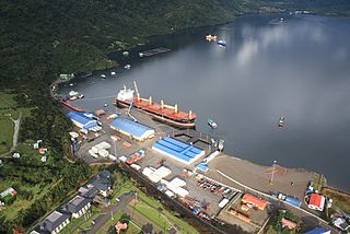
Puerto Chacabuco is a Chilean town in Aisén commune. Administratively it belongs to Aysén Province in Aysén del General Carlos Ibáñez del Campo Region and is located at the head of Aisén Fjord. It is the main port of the region, a port of call for ships sailing to the Laguna San Rafael National Park and the terminus of a Navimag ferry service from Puerto Montt.

Niebla is a coastal Chilean town close to the city of Valdivia, Valdivia Province, Los Ríos Region. Niebla is located on the northern edge, at the mouth of the Valdivia River, across from Corral. Niebla's beach and folk market are popular tourist destinations during the summer, together with the ruins of a Spanish colonial fort and its museum.

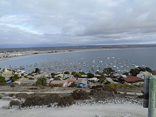
Melinka is a Chilean town in Aysén Province, Aysén Region. It is located on Ascención Island and is the administrative center of the commune of Guaitecas since 1979.

Guaitecas Archipelago is a sparsely populated archipelago in the Aisén region of Chile. The archipelago is made up of eight main islands and numerous smaller ones. The eight largest islands are from northwest to southeast: Gran Guaiteca, Ascención, Betecoy, Clotilde, Leucayec, Elvira, Sánchez and Mulchey. The islands have subdued topography compared to the Andes, with Gran Guaiteca containing the archipelago's high point at 369 m (1,211 ft).
Caleta Chaihuín (Chaihuín) is a coastal hamlet and rural district in the commune of Corral, Los Ríos Region, Chile. It lies at the mouth of Chaihuín River that flows from the Valdivian Coast Range to the Pacific Ocean. Silt from the river combined with the prevailing coastal current have formed a barrier-bar across the cove creating an estuary. The administration and main entrance to the Valdivian Coastal Reserve lies in Chaihuín.
Puerto Cisnes is a town and seaport in Cisnes commune, Aysén Province, Aysén del General Carlos Ibáñez del Campo Region in the Chilean Patagonia. The town is on the Puyuhuapi Channel at the outflow of Cisnes River. The town is located in the northwestern portion of the Aysén Region, an area that includes numerous islands, fjords and channels. The major island is Magdalena Island, which contains the national park that bears its name. Queulat National Park straddles the border between this commune and Lago Verde. Much of the commune area is covered with a lush vegetation and is divided by the Moraleda Channel. The main mountain of the area is Melimoyu volcano.
Llifén is a Chilean town in the commune of Futrono on the shores of Ranco Lake located near the mouth of Calcurrupe River. In 2017 Llifén had a population 768 a slight increase relative to the 748 inhabitants recorded in the 2002 census. LLifén was one of the last places in Chile where artisan fishing was done with fish traps called lollys. Fishing with this technique ceases in the 1970s.
Guape is a hamlet located at coast between Caleta Chaihuín and the port of Corral in Valdivia Province, southern Chile. In 2017 Guape had a population of 224 inhabitants up from 100 in 2002.

Carelmapu is a port and town at the western end of Chacao Channel, southern Chile. Carelmapu was established by the Spanish in 1602 as San Antonio Ribera de Carelmapu following the Destruction of Seven Cities. In 1643 Carealmapu was sacked and its church vandalized by the Dutch corsair Hendrick Brouwer. On March 6, 1676 Carelmapu received the exhausted survivors of Pascual de Iriarte's expedition to the Strait of Magellan.

Bahía Mansa is a settlement and bay located on the coast of Osorno Province, southern Chile. It is the main port between Corral Bay and Maullín River and the only port of Osorno Province. The town's economy revolves around tourism and fishing. Bahía Mansa is the namesake of the Bahía Mansa Metamorphic Complex.
Puaucho is a hamlet located in the West of Osorno Province, southern Chile. Puaucho is the administrative centre of San Juan de la Costa commune. In 2017 Puaucho had a population of 305 inhabitants up from 300 in 2002.
Pargua is a village in Calbuco Comuna, in Los Lagos Region of Chile. It is located on the northeast side of the Chacao Channel. Pargua is on Route 5 and a ferry connects the village with the village of Chacao, Ancud Comuna at the northern end of Chiloé Island. There are plans to build the Chacao Channel bridge across the channel to replace the ferry.

Nueva Braunau is a Chilean village located in the commune of Puerto Varas, Southern Chile. It was founded mostly by Austro-Hungarian settlers from Braunau, Bohemia on 15 August 1877. The settlement originated as part of the German colonization of Valdivia, Osorno and Llanquihue.
Puerto Gala or Gala is a hamlet and fishing community in Toto Island, southern Chile. It is located at the meeting point of Jacaf Channel with Moraleda Channel. The hamlet was established consequence of the merluza boom of the late 1980s. Some early settlers arrived to Gala escaping persecution from the military dictatorship of Pinochet as they lacked the resources to flee abroad. Other early settlers were delinquents who feared torture or death by the authorities. There was a distinct lack of rule of law in the first decades of existence, with police being unable to prevent theft or murder limiting themselves to recover corpses. Because of this police attempted to dissolve the settlement by threatening to evict settlers under the pretext that the settlements were illegal. Evictions attempts failed in the end.
Pedro María Ñancúpel Alarcón was a pirate and outlaw active in the archipelagoes of Chiloé, Guaitecas and other places in the fjords and channels of Patagonia in the 1880s. Ñancupel was captured in Melinka in 1886 and bought into justice in Ancud the same year. After escaping from detainment in Ancud he was captured once again and executed by firing squad on November 11, 1888. He was said at the time to have killed 99 persons.

Chacao is a village located at southern shore of Chacao Channel that separates Chiloé Island from the mainland. Chacao was established as a Spanish outpost with the name of San Antonio de Chacao in 1567 during the conquest of Chiloé.
Tongoy Bay is a bay in Chile's Coquimbo Region. The bay is U-shaped, open to the north. Its western boundary is made up by the hilly and north-protruding Point Lengua de Vaca. More in detail the west boundary of the bay is made up of a seismic fault known as Puerto Aldea Fault. On the shores of the bay lie the towns of Tongoy and Puerto Aldea and their respective beaches. Tongoy Bay is site of recurrent upwelling of cold, acidic and oxygen-poor seawater. Oysters are cultivated in Tongoy Bay.