Puerto Rico Highway 128

Last updated

Ellipse sign 128.svg

Highway 128

Ruta 128
Route information
Maintained by Puerto Rico DTPW
Length58.7 km [1]  (36.5 mi)
Existed1953 [2] –present
Major junctions
South endPR primary 2.svgEllipse sign 3334.svg PR-2  / PR-3334 in Susúa Baja
Major intersections
North endEllipse sign 1111.svgEllipse sign 4128.svg PR-1111  / PR-4128 in Lares barrio-pueblo
Location
Country United States
Territory Puerto Rico
Municipalities Yauco, Maricao, Lares
Highway system
Ellipse sign 127.svg PR-127 PR urban primary 129.svg PR-129
Ellipse sign 4119.svg PR-4119 PR-4128Ellipse sign 4413.svg PR-4413

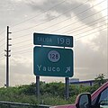
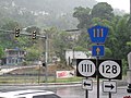
Puerto Rico Highway 128 (PR-128) is a road that travels from Yauco, Puerto Rico to Lares. [3] This highway extends from PR-2 in Yauco and ends at PR-111 near downtown Lares. [4] [5]

Contents

Major intersections

MunicipalityLocationkm [1] miDestinationsNotes
Yauco Susúa Baja 0.00.0PR primary 2.svgEllipse sign 3334.svg PR-2 (Expreso Roberto Sánchez Vilella) / PR-3334  Ponce, Mayagüez, Barina Southern terminus of PR-128; PR-2 exit 198; diamond interchange
0.5–
0.6
0.31–
0.37
Ellipse sign 121.svgEllipse sign 127.svg PR-121  / PR-127 (Calle 25 de Julio) Yauco, Guánica, Sabana Grande
1.4–
1.5
0.87–
0.93
Ellipse sign 368.svg PR-368  Yauco, Sabana Grande
Susúa BajaAlmácigo Bajo line1.8–
1.9
1.1–
1.2
Ellipse sign 376.svg PR-376  Yauco, Almácigo Bajo
Almácigo Bajo 2.21.4Ellipse sign 371.svg PR-371  Yauco, Almácigo Bajo
Almácigo BajoDiego Hernández line3.1–
3.2
1.9–
2.0
Ellipse sign 3372.svg PR-3372 (Calle La Trocha) Yauco
3.3–
3.4
2.1–
2.1
Ellipse sign 372.svg PR-372  Diego Hernández
Naranjo 12.88.0Ellipse sign 373.svg PR-373  Naranjo
Rubias 24.515.2Ellipse sign 374.svg PR-374  Río Prieto
Maricao Indiera Alta 25.716.0Ellipse sign 105.svg PR-105 (Ruta Panorámica) Maricao Southern terminus of the Ruta Panorámica concurrency; the Ruta Panorámica continues toward Sabana Grande
33.120.6Ellipse sign 428.svg PR-428  Indiera Alta
33.120.6Puente de Río Prieto over the Río Prieto [6]
Lares Bartolo 36.822.9Ellipse sign 431.svg PR-431  Río Prieto
37.923.5Ellipse sign 135.svg PR-135 (Ruta Panorámica) Adjuntas Northern terminus of the Ruta Panorámica concurrency
40.625.2Ellipse sign 4428.svg PR-4428  Bartolo
La Torre 44.327.5Ellipse sign 432.svg PR-432  Pezuela
Río Blanco 47.529.5Puente del Río Blanco [6]
La TorreMirasol
Buenos Aires tripoint
52.632.7To plate county (es).svg
PR secondary 129.svg
To PR-129  / PR-Calle La Torre  Utuado, Adjuntas
Buenos AiresLa Torre line54.633.9Ellipse sign 4131.svg PR-4131  La Torre Former PR-431
Lares barrio-pueblo 58.736.5Ellipse sign 1111.svgEllipse sign 4128.svg PR-1111  / PR-4128  Lares Northern terminus of PR-128
1.000 mi = 1.609 km; 1.000 km = 0.621 mi

Ellipse sign 4128.svg

Highway 4128

Location Lares
Length1.2 km [7]  (0.75 mi)

Puerto Rico Highway 4128 (PR-4128) is a bypass road that branches off from PR-128 and ends at PR-111 west of downtown Lares. [3] The entire route is located in Lares barrio-pueblo, Lares. 

km [7] miDestinationsNotes
1.20.75PR secondary 111.svg PR-111 (Avenida Los Patriotas) Utuado, San Sebastián Western terminus of PR-4128
0.00.0Ellipse sign 128.svgEllipse sign 1111.svg PR-128 / PR-1111  Lares, Yauco Eastern terminus of PR-4128
1.000 mi = 1.609 km; 1.000 km = 0.621 mi

See also


Related Research Articles

<span class="mw-page-title-main">Puerto Rico Highway 2</span> Highway in Puerto Rico

Puerto Rico Highway 2 (PR-2) is a road in Puerto Rico that connects the cities of San Juan and Ponce. At 156 miles (230 km) long, it is Puerto Rico's longest singled-signed highway.

<span class="mw-page-title-main">Puerto Rico Highway 115</span> Highway in Puerto Rico

Puerto Rico Highway 115 (PR-115) is a highway which follows the west coastline of Puerto Rico from south Añasco at PR-2 to near downtown Aguadilla, where it becomes Puerto Rico Highway 111 after intersecting PR-2 again, and is the primary route to the town of Rincón, Puerto Rico, a tourist and frequent destination of surfers.

<span class="mw-page-title-main">Puerto Rico Highway 111</span> Highway in Puerto Rico

Puerto Rico Highway 111 (PR-111) is a highway connecting Aguadilla, Puerto Rico at Puerto Rico Highway 2 and Puerto Rico Highway 115 to Utuado, Puerto Rico at Puerto Rico Highway 140.

<span class="mw-page-title-main">Puerto Rico Highway 116</span> Highway in Puerto Rico

Puerto Rico Highway 116 (PR-116) is a main highway in the southwest part of Puerto Rico, beginning in Guánica, Puerto Rico at Puerto Rico Highway 2 to Lajas, Puerto Rico at Puerto Rico Highway 101.

<span class="mw-page-title-main">Puerto Rico Highway 129</span> Highway in Puerto Rico

Puerto Rico Highway 129 (PR-129) is a north–south highway in North-Central Puerto Rico, connecting the town of Lares with Arecibo. It crosses the northern karst country of the island. When traveling from the northern coast of Puerto Rico, PR-129 can be used to reach the Arecibo Observatory and the Camuy River Caverns Park.

<span class="mw-page-title-main">Puerto Rico Highway 156</span> Highway in Puerto Rico

Puerto Rico Highway 156 (PR-156) is a long east–west highway which connects Caguas to Orocovis, passing through Aguas Buenas, Comerío and Barranquitas. This route extends from its junction with PR-1 in downtown Caguas to PR-5155 in downtown Orocovis.

The Ruta Panorámica, officially the Ruta Panorámica Luis Muñoz Marín, is a 167-mile (269 km) network of some 40 secondary roads which traverse the island of Puerto Rico from west to east along its Cordillera Central. Most of the route consists of three roads, PR-105, PR-143, and PR-182. The route starts in Mayagüez and ends in Maunabo. The first major segment of the route runs from Mayagüez to Maricao as Route 105, then from Adjuntas to Aibonito as Route 143, and then follows Route 182 toward Maunabo.

<span class="mw-page-title-main">Puerto Rico Highway 165</span> Highway in Puerto Rico

Puerto Rico Highway 165 (PR-165) is the road that goes from Naranjito to Guaynabo. The highway passes by Toa Alta, Toa Baja, Dorado, Levittown, Cataño and Guaynabo.

<span class="mw-page-title-main">Puerto Rico Highway 124</span> Highway in Puerto Rico

Puerto Rico Highway 124 (PR-124) is a rural road that connects from Lares to Las Marías.

<span class="mw-page-title-main">Puerto Rico Highway 105</span> Highway in Puerto Rico

Puerto Rico Highway 105 (PR-105) is a road that travels from Mayagüez, Puerto Rico to Maricao. It begins at its intersection with PR-239 in downtown Mayagüez and ends at its junction with PR-128 in eastern Maricao, close to Yauco municipal limit.

<span class="mw-page-title-main">Puerto Rico Highway 693</span> Highway in Puerto Rico

Puerto Rico Highway 693 (PR-693) is a road located between the municipalities of Dorado, Puerto Rico and Vega Alta, passing through downtown Dorado. It begins at its intersection with PR-2 and PR-165 in Río Lajas and ends at PR-690 in Sabana. It is a short divided highway in southern Dorado, which serves as an alternate route for PR-165 west of Río de la Plata.

<span class="mw-page-title-main">Puerto Rico Highway 760</span> Highway in Puerto Rico

Puerto Rico Highway 760 (PR-760) is a rural road located in Maunabo, Puerto Rico. It begins at its intersection with PR-3 near downtown Maunabo and ends at Punta Tuna Light.

<span class="mw-page-title-main">Puerto Rico Highway 135</span> Highway in Puerto Rico

Puerto Rico Highway 135 (PR-135) is a rural road that travels from Adjuntas, Puerto Rico to Lares. This highway begins at PR-123 north of downtown Adjuntas and ends at PR-128 in Bartolo.

<span class="mw-page-title-main">Puerto Rico Highway 107</span> Highway in Puerto Rico

Puerto Rico Highway 107 (PR-107), or Carretera Pedro Albizu Campos, is a north–south highway located in Aguadilla, Puerto Rico. It extends from PR-2 to Ramey Air Force Base.

<span class="mw-page-title-main">Puerto Rico Highway 144</span> Highway in Puerto Rico

Puerto Rico Highway 144 (PR-144) is a rural road that travels from Jayuya, Puerto Rico to Ciales. This road extends from PR-140 in Collores and ends at PR-149 in Toro Negro.

<span class="mw-page-title-main">Puerto Rico Highway 121</span> Highway in Puerto Rico

Puerto Rico Highway 121 (PR-121) is a road that travels from Sabana Grande, Puerto Rico to Yauco. This highway begins at its intersection with PR-102 and PR-368 in downtown Sabana Grande and ends at its junction with PR-127 and PR-128 in Susúa Baja.

<span class="mw-page-title-main">Puerto Rico Highway 127</span> Highway in Puerto Rico

Puerto Rico Highway 127 (PR-127) is a road that travels from Yauco, Puerto Rico to Peñuelas. This highway begins at its intersection with PR-121 and PR-128 in Susúa Baja and ends at its junction with PR-2 in Encarnación, passing through downtown Guayanilla.

<span class="mw-page-title-main">Puerto Rico Highway 134</span> Highway in Puerto Rico

Puerto Rico Highway 134 (PR-134) is a rural road that travels from Lares, Puerto Rico to Hatillo. This highway begins at its intersection with PR-111 in barrio Lares and ends at its junction with PR-129 in Campo Alegre.

<span class="mw-page-title-main">Puerto Rico Highway 141</span> Highway in Puerto Rico

Puerto Rico Highway 141 (PR-141) is a road that travels from Jayuya, Puerto Rico to northeastern Utuado. This highway begins at PR-144 in downtown Jayuya and ends at PR-140 in Mameyes Abajo.

<span class="mw-page-title-main">Puerto Rico Highway 125</span> Highway in Puerto Rico

Puerto Rico Highway 125 (PR-125) is a road that travels from Aguadilla, Puerto Rico to San Sebastián, passing through Moca. This highway begins at PR-111 in Palmar and ends at the same highway in Piedras Blancas.

References

  1. 1 2 Google (6 March 2020). "PR-128" (Map). Google Maps . Google. Retrieved 6 March 2020.
  2. "Lares, Memoria Núm. 60" (PDF). Puerto Rico Planning Board (in Spanish). 1955. Retrieved 4 August 2020.
  3. 1 2 National Geographic Maps (2011). Puerto Rico (Map). 1:125,000. Adventure Map (Book 3107). Evergreen, Colorado: National Geographic Maps. ISBN   978-1566955188. OCLC   756511572.
  4. "Tránsito Promedio Diario (AADT)". Puerto Rico Department of Transportation and Public Works (in Spanish). pp. 73–74. Archived from the original on 1 April 2019. Retrieved 31 May 2019.
  5. "Map of Adjuntas at the Wayback Machine" (PDF). Archived from the original (PDF) on 17 April 2015. Retrieved 29 December 2018.
  6. 1 2 Luis F. Pumarada O’Neill (1991). "Los Puentes Históricos de Puerto Rico" (PDF) (in Spanish). Retrieved 10 March 2020.
  7. 1 2 Google (1 March 2020). "PR-4128" (Map). Google Maps . Google. Retrieved 1 March 2020.