Puerto Rico Highway 164

Last updated

PR secondary 164.svg Ellipse sign 164.svg

Highway 164

Ruta 164
Route information
Maintained by Puerto Rico DTPW
Length16.4 km [1] [2]  (10.2 mi)
Existed1953 [3] [4] –present
Major junctions
West endPR secondary 159.svg PR-159 in PuebloPalmarejo
Major intersections
East endPR secondary 148.svgPR secondary 167.svg PR-148  / PR-167 in Nuevo
Location
Country United States
Territory Puerto Rico
Municipalities Corozal, Naranjito
Highway system
PR urban primary 163.svg PR-163 PR urban primary 165.svg PR-165

Puerto Rico Highway 164 (PR-164) is the main road from Naranjito to Corozal in Puerto Rico. [5] It begins at the intersection of PR-167 and PR-148 in eastern Naranjito, passing through downtown. Then it goes to Corozal from its junction with PR-5 and PR-152 until reaching PR-159 near downtown Corozal. [6] This road is 16.4 km (10.2 mi) in length.

Contents

Route description

This highway consists of one lane in each direction for most of its length between Naranjito and Corozal. In Naranjito, PR-164 travels from its intersection with PR-148 and PR-167 in Barrio Nuevo to the Corozal municipal limit, crossing through downtown Naranjito, Achiote and Lomas barrios on its way across this municipality. [7] In Corozal, PR-164 travels from the Naranjito municipal limit to its western terminus at PR-159 junction, passing through Palmarejo and Barrio Pueblo. [8] Among the most important intersections are PR-5, that goes to Bayamón; PR-152, that heads to Barranquitas; PR-159, the main highway between Morovis and Toa Alta; PR-165, which leads to Toa Alta, and PR-167, the main road between Comerío and Bayamón.

Rivers crossed

Puerto Rico Highway 164 crosses the following rivers:

History

The entire length of PR-164 is part of the eastern section of the old Road No. 20, a highway that led from Naranjito to Ciales through Corozal and Morovis until the 1953 Puerto Rico highway renumbering, a process implemented by the Puerto Rico Department of Transportation and Public Works (Spanish : Departamento de Transportación y Obras Públicas) that increased the insular highway network to connect existing routes with different locations around Puerto Rico. Route 20 was divided into two segments: the first one, from Naranjito to Corozal, and the second one, from Corozal to Ciales. [13] The first section corresponds to the current PR-164 from PR-167 (old Road No. 9) to PR-159 (former Road No. 10), [3] while the second one went to Morovis through PR-159, [4] beginning at its junction with PR-568 (old Road No. 10) in western Corozal to continue to Ciales through PR-155, PR-633 and PR-6633 until its end at PR-6685 (former Road No. 11). [14]

Major intersections

MunicipalityLocationkm [1] [2] miDestinationsNotes
Corozal PuebloPalmarejo line16.410.2PR secondary 159.svg PR-159  Corozal, Toa Alta Western terminus of PR-164
Palmarejo 13.78.5Ellipse sign 803.svg PR-803  Palos Blancos
Naranjito Lomas 11.06.8Ellipse sign 8811.svg PR-8811  Lomas
10.9–
10.8
6.8–
6.7
Ellipse sign 811.svg PR-811  Cedro Abajo
9.86.1Ellipse sign 165.svg PR-165  Toa Alta
Achiote 7.74.8Ellipse sign 884.svg PR-884  Achiote
AchioteNaranjito barrio-pueblo line6.4–
6.3 [lower-alpha 1]
4.0–
3.9
Ellipse sign 810.svg PR-810  – Higuillales
South plate county (es).svg
PR secondary 152.svg
PR-152 south Barranquitas
Southern terminus of PR-5 concurrency
South plate county (es).svg
PR secondary 5.svg
PR-5 south (Desvío Mariano Cotto) Corozal, Barranquitas
Northern terminus of PR-5 concurrency
Naranjito barrio-pueblo 6.13.8To plate county (es).svg
PR secondary 5.svg
To PR-5 (Desvío Mariano Cotto) / PR-Calle Marcelino Cruz Cosme  Bayamón
5.93.7Ellipse sign 825.svg PR-825  Achiote
Nuevo 4.93.0To plate county (es).svg
PR secondary 5.svg
PR-147 to PR-5 (Desvío Mariano Cotto) Naranjito
Former highway
2.91.8Ellipse sign 815.svg PR-815  Nuevo
0.70.43Ellipse sign 8126.svg PR-8126  Guadiana Former PR-826
0.00.0North plate county (es).svg
PR secondary 148.svg
PR secondary 167.svgTo plate (es).svg
Ellipse sign 826.svg
PR-148 north / PR-167 to PR-826  Naranjito, Bayamón, Comerío, Guadiana
Eastern terminus of PR-164
1.000 mi = 1.609 km; 1.000 km = 0.621 mi
  1. PR-164 kilometer markers are interrupted on Desvío Mariano Cotto.

See also

Related Research Articles

<span class="mw-page-title-main">Puerto Rico Highway 15</span> Highway in Puerto Rico

Puerto Rico Highway 15 (PR-15), formerly Road No. 4, is a main highway connecting the municipalities of Guayama and Cayey in Puerto Rico. With a length of 25.80 km (16.03 mi), it extends from PR-3 in downtown Guayama to PR-14 in downtown Cayey.

<span class="mw-page-title-main">Río Grande de Manatí</span> River of Puerto Rico

The Manatí River is a river in Puerto Rico, which flows through several northern municipalities of the island. The river is named after the municipality of Manatí where the river mouth is located.

<span class="mw-page-title-main">Puerto Rico Highway 165</span> Highway in Puerto Rico

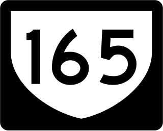
Puerto Rico Highway 165 (PR-165) is the road that goes from Naranjito to Guaynabo. The highway passes by Toa Alta, Toa Baja, Dorado, Levittown, Cataño and Guaynabo.

<span class="mw-page-title-main">Puerto Rico Highway 142</span> Highway in Puerto Rico

Puerto Rico Highway 142 (PR-142) is a north–south road that connects the northern region of Puerto Rico with the municipality of Corozal. With a length of about 8.2 kilometers (5.1 mi), PR-142 crosses the municipalities of Dorado, Toa Alta and Corozal, extending from PR-2 in Dorado to PR-159 near downtown Corozal.

<span class="mw-page-title-main">Puerto Rico Highway 159</span> Highway in Puerto Rico

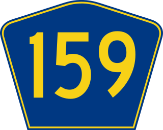
Puerto Rico Highway 159 (PR-159) is the main road from Morovis to Toa Alta, passing through the municipality of Corozal in Puerto Rico. This road begins in downtown Morovis, from its intersection with PR-155 and PR-6623 to its junction with PR-165 in Toa Alta. It is about 21 km (13 mi) long.

<span class="mw-page-title-main">Puerto Rico Highway 891</span> Highway in Puerto Rico

Puerto Rico Highway 891 (PR-891) is the road that goes to downtown Corozal, the administrative center of Corozal, Puerto Rico. With a length of 1.8 km (1.1 mi), this road can be seen as the Alt 159, since it was the original alignment of PR-159 through the municipal center.

<span class="mw-page-title-main">Puerto Rico Highway 139</span> Highway in Puerto Rico

Puerto Rico Highway 139 (PR-139) is a two-way secondary highway in the municipality of Ponce in Puerto Rico. With a length of 25.2 km (15.7 mi), it extends from the interchange of PR-10 and PR-14 located in Barrio Machuelo Arriba to the junction with PR-143 on the Ponce–Jayuya municipal limit.

<span class="mw-page-title-main">Puerto Rico Highway 145</span> Highway in Puerto Rico

Puerto Rico Highway 145 (PR-145) is a rural road that travels from Ciales, Puerto Rico to Morovis. This road extends from its junction with PR-146 and PR-149 in downtown Ciales and ends at PR-155 between Morovis Norte, Torrecillas and Fránquez barrios.

<span class="mw-page-title-main">Puerto Rico Highway 152</span> Highway in Puerto Rico

Puerto Rico Highway 152 (PR-152) is a rural road that travels from Barranquitas to Naranjito in Puerto Rico. This road extends from PR-156 in downtown Barranquitas and ends at its junction with PR-5 and PR-164 near downtown Naranjito.

<span class="mw-page-title-main">Puerto Rico Highway 568</span> Highway in Puerto Rico

Puerto Rico Highway 568 (PR-568) is a road that travels from the municipality of Orocovis to Corozal in Puerto Rico. With a length of 30.1 km (18.7 mi), it begins at its intersection with PR-5155 in downtown Orocovis and ends at PR-159 in western Corozal.

<span class="mw-page-title-main">Puerto Rico Highway 803</span> Highway in Puerto Rico

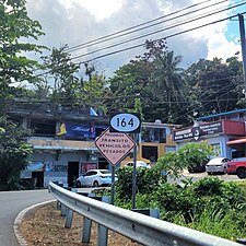
Puerto Rico Highway 803 (PR-803) is a north–south road that travels from eastern Corozal to southwestern Naranjito in Puerto Rico. With a length of 10.2 km (6.3 mi), it begins at PR-164 in Palmarejo barrio and ends at its junction with PR-152 and PR-802 in Cedro Arriba barrio.

<span class="mw-page-title-main">Puerto Rico Highway 807</span> Highway in Puerto Rico

Puerto Rico Highway 807 (PR-807) is a north–south road located in the municipality of Corozal in Puerto Rico. With a length of 6.9 km (4.3 mi), it begins at Calle San Manuel in downtown Corozal, passing through Dos Bocas barrio until its southern terminus at its junction with PR-805 on the Palos Blancos–Negros line.

<span class="mw-page-title-main">Puerto Rico Highway 818</span> Highway in Puerto Rico

Puerto Rico Highway 818 (PR-818) is an east–west road located in the municipality of Corozal in Puerto Rico. With a length of 4.3 km (2.7 mi), it begins at its junction with PR-159 in Barrio Pueblo, and ends at Baja del Palo sector in Barrio Cibuco.

<span class="mw-page-title-main">Puerto Rico Highway 821</span> Highway in Puerto Rico

Puerto Rico Highway 821 (PR-821) is a north–south road located in the municipality of Corozal in Puerto Rico. With a length of 6.0 km (3.7 mi), it begins at its intersection with PR-891 between downtown Corozal and Barrio Pueblo, passing through Abras barrio until its terminus at PR-630 near Mavilla barrio of Vega Alta municipality.

<span class="mw-page-title-main">Puerto Rico Highway 633</span> Highway in Puerto Rico

Puerto Rico Highway 633 (PR-633) is an east–west rural road located between the municipalities of Ciales and Morovis in Puerto Rico. With a length of 4.3 km (2.7 mi), it begins at its intersection with PR-149 in Hato Viejo barrio and ends at its junction with PR-155 in Barahona.

<span class="mw-page-title-main">Puerto Rico Highway 647</span> Highway in Puerto Rico

Puerto Rico Highway 647 (PR-647) is a north–south road located between the municipalities of Corozal and Vega Alta in Puerto Rico. With a length of 12.8 km (8.0 mi), it extends from its junction with PR-159 and PR-5568 on the Cibuco–Padilla line in western Corozal, passing through Cienegueta, Candelaria and Bajura barrios until its end at PR-676 in downtown Vega Alta.

<span class="mw-page-title-main">Puerto Rico Highway 810</span> Highway in Puerto Rico

Puerto Rico Highway 810 (PR-810) is a north–south road located entirely in the municipality of Naranjito in Puerto Rico. With a length of 3.7 kilometers (2.3 mi), it begins at its intersection with PR-164 on the downtown Naranjito–Achiote line, and ends at its junction with PR-152 in Cedro Abajo barrio.

<span class="mw-page-title-main">Puerto Rico Highway 802</span> Highway in Puerto Rico

Puerto Rico Highway 802 (PR-802) is an east–west road between the municipalities of Corozal and Naranjito in Puerto Rico. With a length of 6.6 kilometers (4.1 mi), it begins at its intersection with PR-801 in Palmarito barrio in Corozal, and ends at its junction with PR-152 and PR-803 in Cedro Arriba barrio in Naranjito.

<span class="mw-page-title-main">Puerto Rico Highway 806</span> Highway in Puerto Rico

Puerto Rico Highway 806 (PR-806) is a north–south road between the municipalities of Corozal and Toa Alta in Puerto Rico. With a length of 1.9 kilometers (1.2 mi), it begins at PR-159 junction between Palmarejo and Abras barrios in Corozal, and ends at PR-823 intersection in Quebrada Arenas barrio in Toa Alta.

References

  1. 1 2 Google (2 March 2020). "PR-164 east" (Map). Google Maps . Google. Retrieved 2 March 2020.
  2. 1 2 Google (2 March 2020). "PR-164 west" (Map). Google Maps . Google. Retrieved 2 March 2020.
  3. 1 2 "Naranjito, Memoria Núm. 53" (PDF). Puerto Rico Planning Board (in Spanish). 1955. Retrieved 6 August 2023.
  4. 1 2 "Corozal, Memoria Núm. 61" (PDF). Puerto Rico Planning Board (in Spanish). 1955. Retrieved 22 February 2020.
  5. National Geographic Maps (2011). Puerto Rico (Map). 1:125,000. Adventure Map (Book 3107). Evergreen, Colorado: National Geographic Maps. ISBN   978-1566955188. OCLC   756511572.
  6. Puerto Rico Department of Transportation and Public Works. "Datos de Transito 2000-2009" (in Spanish). Archived from the original on 1 April 2019. Retrieved 29 April 2019.
  7. "PR-164, Naranjito, Puerto Rico". pr.geoview.info. Retrieved 5 August 2023.
  8. "PR-164, Corozal, Puerto Rico". pr.geoview.info. Retrieved 5 August 2023.
  9. Press, Detroit Free. "PR 164 over ANONES CREEK Naranjito Municipio, Puerto Rico Bridge Inspection Report". Detroit Free Press. Retrieved 9 August 2023.
  10. Press, Detroit Free. "PR 164 over CA%AS RIVER Naranjito Municipio, Puerto Rico Bridge Inspection Report". Detroit Free Press. Retrieved 9 August 2023.
  11. Press, Detroit Free. "PR 164 over GUADIANA RIVER Naranjito Municipio, Puerto Rico Bridge Inspection Report". Detroit Free Press. Retrieved 9 August 2023.
  12. Press, Detroit Free. "PR 164 over MAVILLA RIVER Corozal Municipio, Puerto Rico Bridge Inspection Report". Detroit Free Press. Retrieved 9 August 2023.
  13. "Revista de Obras Públicas de Puerto Rico, Febrero 1929". Colección Puertorriqueña UPR RP (in Spanish). 1929. pp. 22–23. Retrieved 6 August 2023.
  14. "Morovis, Memoria Núm. 65" (PDF). Puerto Rico Planning Board (in Spanish). 1955. Retrieved 6 August 2023.