
Kasaragod is a municipal town and administrative headquarters of Kasaragod district in the state of Kerala, India. Established in 1966, Kasaragod was the first municipal town in the district. It is the northernmost district of Kerala and is also known as Sapta Bhasha Sangama Bhumi.
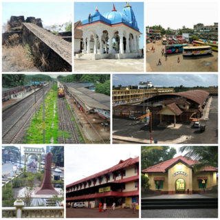
Kanhangad is a major town, located in the Kasaragod District, state of Kerala, India.

Payyanur, is a municipal town and a taluk, a sub-district administrative unit, in the Kannur district of Kerala, India. Payyanur is the first municipality in Kerala to establish libraries in all its wards. On 10 March 2018, Kerala Chief Minister Pinarayi Vijayan inaugurated Payyanur as the fifth taluk in the district. Payyanur taluk comprises 22 villages including 16 de-linked from the Taliparamba taluk and six from the Kannur taluk. The town is situated on the banks of the Perumba River.
Nileshwaram or Nileshwar or Neeleswaram is a municipality and a major town in Kasaragod District, state of Kerala, India. It is one of the three municipalities in Kasaragod district; the others are Kasaragod and Kanhangad. Nileshwaram is located on the estuary of Kavvayi Backwaters and Neeleshwaram River. Nileshwaram is referred to as the cultural capital of Kasaragod, the northernmost district of Kerala. "The first Chief Minister of Kerala and communist leader E. M. S. Namboodiripad had contested elections to the Assembly from the Neeleswaram segment."

Kadakkal is a historic city located in the eastern part of Kollam district, Kerala. It is 44 km away from both Kollam City and Thiruvananthapuram. State highway 64 passes through the town. Kadakkal is well known for the social revolutionary activities held in the pre-independent period of India.The town is an important business centre and is known for its Trade ,Kadakkal Viplavam Kadakkal Riot Case,Festivals ,Religious unity & spice production. Kadakkal is reachable through Nilamel, and is well connected to nearby villages like Anchal, Kilimanoor, Parippally and Madathara. Kadakkal is one of the place which facilitates the easiest roadway access to the neighbouring state Tamil Nadu & is one of the upcoming Municipality in Kollam district. The town is only 50 km away from Tamil Nadu border, Trivandrum central & Kollam city.
Meppayur is a town in Kozhikode district of Kerala state, South India.

Kasaragod (pronounced[kaːsɐrɡoːɖɨ̆] is one of the 14 districts in the southern Indian state of Kerala. Its northern border Thalappady is located just 9 km south to Ullal, which is the southernmost portion of the major port city Mangalore, on the southwestern Malabar coast of India.
Athinhal is a coastal village in Kasaragod district in the Indian state of Kerala. It is 28 km from the district capital of Kasaragod and one kilometer north of Kanhangad.
Maloth (also known as malom) is a village in Kasaragod district of the state of Kerala., Maloth is a village in Western Ghats. It is situated in the Balal Panchayath of Kasaragod District of Kerala. It is a part of the Kasaragod Parliament constituency. Earlier it was in the Hosdurg assembly constituency which is renamed as Kanhangad after the delimitation of assembly constituencies in 2011. It shares borders with the Karnataka forest. Nearest towns are Kanhangad, Cherupuzha, and Nileshwaram. One can reach Maloth through bus from Kanhangad or from Cherupuzha. Private as well as KSRTC buses playing between Kanhangad and Konnakkad passes through the village.
Panathady is a village in Kasaragod district in the state of Kerala, India. Panathady Panchayat is in Vellarikundu taluk. It is 35 kilometers away from the nearest municipality, Kanhangad, and it is 7.5 kilometers away from the Kerala-Karnataka border town, Panathur.
Periya is a small township in Kasaragod District, Kerala State, India.
Pallickal is a panchayath in Varkala Taluk of Trivandrum district in the state of Kerala, India. It is situated 18 km east of Varkala along Varkala - Madathara State Highway 64 and 46 km north-east of capital city Trivandrum. It is known for its lush paddy fields and Land of Volleyball in south kerala. More over, this village is full of Sports enthusiasts and supporters.

Hosdurg is one of four taluks that constitute the Kasaragod District, Kerala. Others are Kasaragod, Manjeshwaram and Vellarikundu taluks. In the north, it borders Kasaragod taluk; in south, the Kannur District; in the east, Vellarikundu taluk; and in the west, the Arabian Sea. With an area of 900.3 km2, it was the smaller of the two taluks. Then Hosdurg bifurcated into Vellarikund and Hosdurg taluks in 2013 for ease of administration. Kanhangad and Nileshwaram are the municipalities within the taluk. Hosdurg is a kilometer south of Kanhangad town, the latter being the taluk headquarters. Other major settlements include Trikarpur, Cheruvathur and Udma. Bekal Fort tourism is situated in the taluk.

Vellarikund is a town and taluk headquarters in the Hill range of Kasaragod District in the state of Kerala. Vellarikundu is located between Odayanchal and Chittarikkal on Odayanchal-Cherupuzha Road.

Panathur is a major town in Vellarikundu Taluk of Kasaragod district in Kerala State, India. It belongs to Kanhangad legislative constituency. Its population is about 12,000. It lies 1 km away from Kerala - Karnataka border, 42 km away from the nearest municipality, Kanhangad and 53 km away from the district headquarters, Kasaragod. It is surrounded from three sides by forest reserves and cashew plantations. Kudumbur River flows adjacent to the town.

Kasaragod District is the northernmost district in the southwestern Indian coastal state of Kerala. The district has a long history starting from pre-historic times to the modern period.

Mulleria is a small town located in Karadka Panchayath, Kasaragod district in Kerala, India.

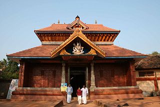
Altharakkal Sree Muthappan Madapura is a temple, located at Pullur Village about 6.2 km from Kanhangad City and 25 km from Kasaragod City in Kasaragod District, Kerala. Principal deity of the temple is Sree Muthappan, whose divinity is presented as a ritualistic theyyam enactment in two versions called Thiruvappana and Vellattam. According to the local tradition the presiding deity is a manifestation of Lord Shiva.

