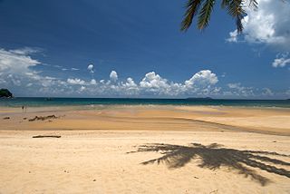
Tioman Island is 32 kilometres off the east coast of Rompin District, Pahang, Malaysia. It is 39 kilometres long and 12 kilometres wide and has seven villages, the largest and most populous being Kampung Tekek on the central western coast. The densely forested island is sparsely inhabited, and is surrounded by numerous coral reefs, making it a popular scuba diving, snorkelling, and surfing spot. There are many resorts and chalets for tourists around the island, which has duty-free status.

Pulau Tekong, also known colloquially as Tekong or Tekong Island, is the second-largest of Singapore's outlying islands after Jurong Island. Tekong is located off Singapore's northeastern coast, east of Pulau Ubin. Since the 1990s, the island has been used by the Singapore Armed Forces (SAF) and is generally restricted from public access. Transport to the island for permitted persons is via the SAF Changi Ferry Terminal at Changi Beach.

Pulau Ubin, also simply known as Ubin, is an island situated in the north east of Singapore, to the west of Pulau Tekong. The granite quarry used to be supported by a few thousand settlers on Pulau Ubin in the 1960s, but only about 40 villagers remained as of 2012. It is one of the last rural areas to be found in Singapore, with an abundance of natural flora and fauna. The island forms part of the Ubin–Khatib Important Bird Area (IBA), identified as such by BirdLife International because it supports significant numbers of visiting and resident birds, some of which are threatened. Today, the island is managed by the National Parks Board, compared to 12 agencies managing different areas of the island previously.

Sisters' Islands are two of the Southern Islands in Singapore and are located to the south of the main island of Singapore, off the Straits of Singapore. It can be reached via a boat ride from Marina South Pier or West Coast Pier.
Bukit Merah, also known as Redhill, is a planning area and new town situated in the southernmost part of the Central Region of Singapore. The planning area borders Tanglin to the north, Queenstown to the west and the Downtown Core, Outram and Singapore River planning areas of the Central Area to the east. It also shares a maritime boundary with the Southern Islands planning area to the south. Bukit Merah is linked to Sentosa Island via Sentosa Gateway, Sentosa Broadwalk, Sentosa Express and the Cable Car.
Pulau Semakau is located to the south of the main island of Singapore, off the Straits of Singapore. The Semakau Landfill is located on the eastern side of the island, and was created by the amalgamation of Pulau Sakeng, and "anchored" to Pulau Semakau. The Semakau Landfill is Singapore's first offshore landfill and now the only remaining landfill in Singapore.

Mersing is a town, mukim and the capital of Mersing District, Johor, Malaysia. The town is located at the southern end of the east coast of Peninsular Malaysia. As of 2010, the town has an estimated population of 70,894.

The Southern Islands is a planning area consisting of a collection of islets located within the Central Region of Singapore, once home to the native Malay islanders and sea nomads before they were relocated to the mainland for urban redevelopment and future use. The islands that form the planning area are Kusu Island, Lazarus Island, Pulau Seringat, Pulau Tekukor, Saint John's Island, Sentosa and the two Sisters' Islands. The islands encompass a total land area of about 5.58 square kilometres (2.15 sq mi). The Sentosa Development Corporation oversaw the development and maintenance of these offshore islands south of Singapore from 1976 to March 2017, when it handed it back to the Singapore Land Authority.

This article shows the notable future developments in Singapore. Most of them are currently under construction with most to be completed within the next five years.
Labrador Nature Reserve, also known locally as Labrador Park, is located in the southern part of mainland Singapore. It is home to the only rocky sea-cliff on the mainland that is accessible to the public. Since 2002, 10 hectares of coastal secondary-type vegetation and its rocky shore have been gazetted as a nature reserve and its flora and fauna preserved by NParks.

Weh Island is a small active volcanic island to the northwest of Sumatra in Indonesia, also known as Sabang after the city situated on the northeast end of the island, whose area of 122.13 square kilometres (47.15 sq mi) includes the whole island as well as several offshore islets. It had a population of 43,527 at the official mid-2023 estimate. It is 45 minutes by fast regular ship or 2 hours by ferry from the mainland port of Banda Aceh. It was originally connected to the Sumatran mainland and became separated by sea after the stratovolcano's last eruption in the Pleistocene era. The island is situated in the Andaman Sea.
Relau is a suburb of George Town in the Malaysian state of Penang. It is located 9.9 km (6.2 mi) southwest of the city centre, between Paya Terubong to the north, Bayan Lepas to the east and Balik Pulau to the west.
The North-Eastern Islands is a planning area and a group of islands located within the North-East Region of Singapore. The cluster is made up of three islands, namely Pulau Tekong, Pulau Tekong Kechil and Pulau Ubin. Pulau Tekong and Pulau Tekong Kechil was formerly home to 10 villages while Pulau Ubin was home to a number of granite quarries. At present, Pulau Tekong houses the Singapore Armed Forces Basic Military Training Centre while Pulau Ubin is one of the last areas in Singapore that has been preserved from urban development, concrete buildings and tarmac roads.

Tioman Airport, also known as Pulau Tioman Airport, is an airport serving Tioman Island, Pahang, Malaysia. It is located next to Tekek village . The relatively small size of aircraft able to take off and land at Tioman means that per seat costs are relatively high, making it hard for airlines operating out of the island to remain profitable. The airport's runway is "one way" as planes can only land and take off in one direction (north) due to nearby terrain. Tioman is a popular destination for private pilots based in Singapore and Malaysia, as it is only a little more than an hour away by air from Seletar Airport, Singapore compared to over 5 hours by surface transport.

Heritiera littoralis, commonly known as the looking-glass mangrove or tulip mangrove, is a mangrove tree in the family Malvaceae native to coastal areas of eastern Africa, Asia, Melanesia and northern Australia. The common name refers to the silvery appearance of the underside of the leaves, resembling a mirror to some degree. The strong timber has uses in marine applications and elsewhere.

Pulau Merambong, formerly known as Pulo Ular, is an uninhabited island on the Straits of Johor. The island is dominated by mangrove swamp. It is located just 1 kilometre off the coast from Tuas, Singapore. Administratively, it is placed under the Pontian District, Johor, Malaysia.

The Aur Island is an island in Mersing District, Johor, Malaysia. It lies about 76 kilometres (47 mi) east of Mersing Town and is part of the Johor Marine Park. Its corals, lagoons and offshore pools make it a tourist attraction. It has for many years also been a frequent stopover point for fishermen.
Sisters’ Islands Marine Park is a 400,000 square metre(40ha) marine park located in Southern Islands planning area, Singapore, which was designated a marine protected area (MPA) by the Government of Maritime and Port Authority of Singapore in 2014. The park encompasses the land and waters surrounding Sisters' Islands, and also covers the western coasts of both St John's Island and Pulau Tekukor.
Pulau Saigon was a small island in the Singapore River. It used to be located between the banks of Robertson Quay.

The German Girl Shrine is a shrine on the island of Pulau Ubin in Singapore. It marks the site of the burial of an unknown 18-year-old girl who died on the island in 1914 after falling from a cliff while fleeing from British forces who sought to detain a number of German nationals then resident on the island. Her body was recovered and interred in an urn on the site by Chinese workers, and a makeshift shrine structure was built. The site was visited frequently by gamblers who thought the spirit of the girl would bring them good luck. A permanent structure was erected in 1974 by a company carrying out quarrying on the island. Quarrying has since ceased, and the shrine is now within Ketam Mountain Bike Park. Visitors often leave offerings, including makeup and Barbie dolls, at the site.

