
Snoqualmie Pass is a census-designated place (CDP) in King and Kittitas Counties, Washington, United States. The population was 311 at the 2010 census.

A ski resort is a resort developed for skiing, snowboarding, and other winter sports. In Europe, most ski resorts are towns or villages in or adjacent to a ski area – a mountainous area with pistes and a ski lift system. In North America, it is more common for ski areas to exist well away from towns, so ski resorts usually are destination resorts, often purpose-built and self-contained, where skiing is the main activity.

The Wasatch Range is a mountain range that stretches approximately 160 miles (260 km) from the Utah-Idaho border, south through central Utah in the western United States. It is the western edge of the greater Rocky Mountains, and the eastern edge of the Great Basin region. The northern extension of the Wasatch Range, the Bear River Mountains, extends just into Idaho, constituting all of the Wasatch Range in that state.
Purden Lake Provincial Park is a provincial park in British Columbia, Canada.

Diamond Peak is a ski resort in the western United States, located in Incline Village, Nevada. Near the northeast shore of Lake Tahoe, the resort has 6 chairlifts, 30 runs, open glades, and tree skiing on its 655 acres (2.65 km2) of terrain.

Lost Lake is a desert community located along the west shore of the Colorado River. It also lies along U.S. Route 95 near the northeast extent of Riverside County. Official U.S. Geological Survey feature ID is 245216 and NAD27 coordinates for the community are 34°00′44″N114°28′27″W. The community lies at the foot of Riverside Mountain, 34°00′49″N114°30′45″W, with a summit measuring 2,127 feet. The community is named for a lake, Lost Lake, located at 34°01′20″N114°28′21″W.

Barefoot Bay is an unincorporated, deed-restricted manufactured home community, recreation district, and water and sewer district in southern Brevard County, Florida. The population at the 2010 United States Census was 9,808.
The High Rockies, or high country, is a term for a region of the U.S. state of Colorado. It commonly includes Larimer County, Jackson County, Routt County, Grand County, Summit County, Eagle County, Lake County, and Pitkin County. Some notable towns there include Estes Park, Walden, Steamboat Springs, Grand Lake, Winter Park, Breckenridge, Dillon, Vail, Leadville, and Aspen. The geography of the High Rockies has some of the most rugged parts of the Rocky Mountains and consists of the Front Range and mountainous topography to the west, much of which is on or near the Continental Divide. Known for pine forests and winding roads, the former mining towns there have been reinvented by wilderness tourism such as hiking, cycling, fishing, and most especially both cross-country and alpine skiing. Notable ski resorts include Copper Mountain, Keystone Resort, Steamboat Ski Resort, Beaver Creek Resort, Buttermilk, Aspen Highlands, Snowmass, and Aspen Mountain. The High Rockies are also the location of Rocky Mountain National Park and Arapaho National Forest.
Nub's Nob is a ski area located in the township of Pleasantview near Harbor Springs, Michigan. Opened by Norman and Dorie Sarns in 1958 as a small ski hill, it has sprawled out to a fairly large resort with eleven lifts. It gets its name from the nickname of founder Norman "Nubby" Sarns.
The Flathead Valley, located in Northwestern Montana, is a region of the U.S. state of Montana. It includes Flathead County, and part of Lake County. Notable towns include Bigfork, Kalispell, Columbia Falls, Polson, and Whitefish. The geography of the Flathead roughly corresponds to the valley where Flathead Lake is located. In addition to the lake, the area's proximity to attractions such as Glacier National Park and Whitefish Mountain Resort have made the area a major resort destination. Many outdoor activities can be pursued there such as hiking, backpacking, rafting, canoeing, skiing, hunting, and some of the best trout fishing in the world. The Flathead Valley is also home to a portion of the Flathead Indian Reservation.

Odell Lake is located near Willamette Pass in the northwest corner of Klamath County, Oregon, United States. It is one of several lakes in the Cascade Range in Central Oregon, and lies within the Deschutes National Forest. It was named for Oregon Surveyor General William Holman Odell by Byron J. Pengra, in July 1865, while they were making a preliminary survey for the Oregon Central Military Road, which would later become Oregon Route 58. The lake fills a basin carved by a glacier, and the resulting terminal moraine confines the water along the lake's southeast shore.
Troll Ski Resort, often referred to simply as Troll, is a ski area located in the Quesnel Highland in the northeastern Cariboo region of British Columbia, Canada, located between Quesnel and the historic goldfield towns of Wells-Barkerville. The official name of the locality where Troll is located is Pinegrove, British Columbia, which is located between Coldspring House (SW) and Beaver Pass House (NE) on the Barkerville Highway).

Mount Tabor, 1,247 m (4,091 ft), is a mountain 20 km (12 mi) east of Prince George, British Columbia, Canada adjacent to BC Highway 16. It rises about 550 m (1,804 ft) from the small portion of the Nechako Plateau that lies in the angle of the Fraser River and not part of the Cariboo Mountains which begin just to the east, the summit is the site of a former fire lookout tower and is the highest piece of relief in the Greater Prince George area.
Sasquatch Mountain Resort is a small ski resort located in the Douglas Ranges near Chehalis, British Columbia, Canada, between the towns of Mission and Agassiz. It is now going to be called Sasquatch Mountain (2017)
Summit Lake Ski Area is a small community-operated ski hill located at the lake and community of the same name, 16km east of Nakusp, British Columbia, Canada, in that province's Arrow Lakes-Slocan region. The hill, located at the east end of the lake adjacent to BC Hwy 6 has a T-Bar and rope tow and a daylodge with cafeteria with rentals and lessons. The area features night skiing, snowboarding, a halfpipe, a 1km cross-country ski trail, and a terrain park for summer use.
Tabor Mountain Ski Resort, also known as Tabor Mountain Alpine Resort, is a ski resort located 20 km (12 mi) east of Prince George, British Columbia, Canada, adjacent to BC Hwy 16 on Mount Tabor.
Sonans is an unincorporated community in Pittsylvania County, in the U.S. state of Virginia.

School Knott is a hill in the Lake District, England, to the east of Windermere town, Cumbria. It is the subject of a chapter of Wainwright's book The Outlying Fells of Lakeland. His recommended route starts at Windermere railway station and includes Grandsire at 818 feet (249 m) and a nameless summit at 806 feet (246 m). The summit is at 760 feet (230 m) and offers a view of four sections of Windermere, the lake. It has a rocky outcrop but no trig point and, as reported by Wainwright, no cairn. Schoolknott Tarn is to the south-east of the summit.
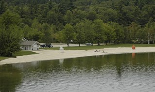
Mount Sunapee State Park is a state park in Newbury, New Hampshire. The park includes a beach portion on Lake Sunapee and most of Mount Sunapee. The state has leased the ski area to Mount Sunapee Resort.


