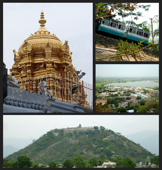
Palani or Pazhani or "Pallhani" is a town in Dindigul district of Tamil Nadu state in India. It is located about 54 kilometres (34 mi) west of Dindigul, 106 kilometres (66 mi) south-east of Coimbatore, 122 kilometres (76 mi) north-west of Madurai, 67 kilometres (42 mi) from Kodaikanal. The Palani Murugan Temple or Arulmigu Dhandayuthapani Swamy Temple, dedicated to Murugan is situated on a hill overlooking the town. The temple is visited by more than 7 million pilgrims each year. As of 2011, the town had a population of 70,467 and the Taluk had a population of 292,301 which makes it the second largest town in the district after Dindigul.
Kakkayur is a small village between Koduvayur, Pallavur and Kunisseri in Palakkad district of Kerala state, south India. Kakkayur is on the Palakkad Nemmara route about 13 km from Palakkad town. It is part of Koduvayur Grama Panchayat. The population is around 8500 and the literacy of the village stands at 86.3%.
Kizhakkancherry is a gram panchayat in the Palakkad district, state of Kerala, India. It is a local government organisation that serves the villages of Kizhakkencheri-I and Kizhakkencheri-II. It was formed in the year of 1951 and is the fourth largest grama panchayath in Kerala. It covers an area of 112.56 km2 and comprises 22 wards. The boundaries are Vadakkencherry (north), Pananjeri (south), Vandazhy (east) and Kannambra (west). The village is located 37.4 km from the city of Palakkad and 34.9 km from Thrissur.
Palappuram is a neighbourhood in Ottapalam located 4 km from Ottapalam, between Shornur and the Palakkad Highway in Kerala, South India. In olden days most of them were farmers and weavers. There are various temple in this village. Chinakkathur Kavu, Mariyamman temple, NeeliKavu, and Sree Kurumba kavu.

Palakkad, also known as Palghat, historically known as Palakkattussery, is a municipality in the Indian state of Kerala. It is the administrative headquarters of Palakkad District. Palakkad is the most densely populated municipality and the fourth-most densely populated city in the state. It was established before Indian independence under British rule and known by the name Palghat. Palakkad is famous for the ancient Palakkad Fort, which is in the heart of the city and was captured and rebuilt by Hyder Ali in 1766 which later fell into the hands of Zamorin in 1784. The city is about 347 kilometres (216 mi) northeast of the state capital, Thiruvananthapuram.

Ernakulam is the central business district of the city of Kochi, Kerala, India. It is the namesake of Ernakulam district. The eastern part of Kochi city is mainly known as Ernakulam, while the western part of it after the Venduruthy Bridge is called as Western Kochi. Many major establishments, including the Kerala High Court, the office of the Kochi Municipal Corporation and the Cochin Shipyard are situated in Ernakulam. It is also the most urbanized area in the city of Kochi. The Southern Naval Command (SNC) is in Kochi, Ernakulam district, Kerala. Established in 1958, it is the largest naval command of the Indian Navy, focusing on training and maritime security operations in the Arabian Sea and Indian Ocean.

Chittur-Thathamangalam is a town and municipality in Palakkad district of Kerala State, India. It is the headquarters of Chittur taluk, 13 km (8.1 mi) south-east of Palakkad, on the banks of the Kannadipuzha, a major headstream of the Bharathapuzha, the second longest river in Kerala. A Mini Civil Station is also located here which provides government related services. It consists of two areas, Chittur and Thathamangalam which together form the municipality.
Vengad is a gram panchayat situated in Thalassery taluk, Kannur district, Kerala, India, on the banks of the Anjarakandi River. Vengad is famous for its black pepper and handloom. One state seed farm is located in Vengad. Vengad gram panchayat consists of 21 wards; viz Pattathari (1), Kallayi (2), Vengad Angadi (3), Vengad Metta (4), Vengad Theru (5), Oorppalli (6), Kaitheripoyil (7), Valankichal (8), Pathiriyad (9), Pachapoika (10), Parambayi (11), Kelalur (12), Mambaram (13), Poyanad (14), Keezhathur Balavadi (15), Keezhathur Vayanasala (16), Kuzhiyil Peedika (17), Mailulli (18), Kunnirikka (19), Paduvilayi (20) and Thattari (21).
Cheriyamundam is a village and Grama Panchayat in Kerala, India. It covers an area of 11.95 km2 and includes 25,760 (1991) inhabitants. It lies near the Tirur River.
Trikkatiri, alternatively spelt as Thrikkadeeri is a town in Ottapalam Taluk, Palakkad district, Kerala state, India. It is located in the route from Ottapalam to Perinthalmanna. There is a famous temple dedicated to Trimurtis of Hindu pantheon - Brahma, Vishnu and Shiva - here. Popularly known as Moonnumoorthi Temple, it has a rare idol with three faces representing the three deities. The village is famous for that phenomenon.

Shekharipuram(also spelled as Sekharipuram) is a residential area in Palakkad, in the Indian state of Kerala. Sekharipuram is famous for its agraharam(heritage village). The Calicut bypass road which starts from Sekharipuram is a 4 lane bypass road constructed for the vehicles coming from other parts of Kerala going towards Tamil Nadu side by bypassing Palakkad town.
Pathirippala is a town in Palakkad district, Kerala, India, between Ottappalam and Palakkad on the Palakkad–Ponnani state highway SH 23.

Olavakkode is a region in Palakkad city, Kerala, India. It is composed of two main areas: the Kavilpad and the Railway Colony. Olavakkode is located 4 km from Palakkad city and lies on National Highway 966. It is one of the major suburbs of Palakkad city as Palakkad Junction railway station one of the major stations of the city is located there.
Karuvarakundu is a semi-urban area in the eastern part of Malappuram district, Kerala, India. It is situated 32 kilometres (20 mi) east of Manjeri, 26 kilometres (16 mi) northeast of Perinthalmanna and 30 km southeast of Nilambur. The Olippuzha River, a tributary of the Kadalundipuzha, flows through the town. Karuvarakundu is close to the Western Ghats and hence prone to landslides.
Pulamanthole is a Panchayath in Malappuram district of Kerala, India. It is situated on the banks of the Kunthippuzha. The river separates Malappuram and Palakkad districts, a new bridge has been built across it recently.

.
Puthanathani is a census town in Malappuram district in the state of Kerala, India. and forms a part of Malappuram metropolitan area. It is also one of the major commercial towns under the Malappuram urban agglomeration. The town lies on the National Highway 66 (India), between Kottakkal and Valanchery. Roads to Vailathur and Thirunavaya also can be seen in Puthanathani.

Kuttippala is a village in Malappuram district of Kerala which is situated 8 km (5 mi) from Tirur on the way to Kottakkal and is a junction which leads to Kurukkol and Kozhichena.

Kanjikode or Kanchikode is an industrial town located 13 km (8.1 mi) east of Palakkad. Kanjikode is the second largest industrial hub in Kerala after Kochi. The town is part of Pudussery Panchayat. It is one of the growing suburbs of Palakkad city. First and the only Indian Institute of Technology in Kerala, Indian Institute of Technology,Palakkad was established in Kanjikode. The upcoming Industrial Smart City project is going to be established in Kanjikode.

Kalpathy or Kalpathi is a residential area in Palakkad city, Kerala, India. It is famous for the Viswanatha Swamy Temple, which is located along the banks of the Kalpathy river, one of the tributaries of the Bharathapuzha. It is also famous for the Kalpathy Radholsavam, which is an annual car festival taking place in the month of Thulam(November).


