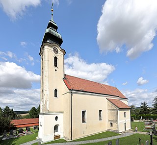
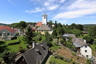
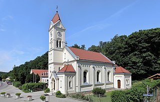
Pyhra

Last updated • 1 min readFrom Wikipedia, The Free Encyclopedia
Pyhra
Pfarrkirche Pyhra 1.jpg
Pyhra parish church
AUT Pyhra COA.png
Austria adm location map.svg
Red pog.svg
Pyhra
Location within Austria
Coordinates: 48°9′N15°41′E / 48.150°N 15.683°E / 48.150; 15.683
Country Austria
State Lower Austria
District Sankt Pölten-Land
Government
   Mayor Günter Schaubach
Area
[1]
  Total
66.77 km2 (25.78 sq mi)
Elevation
298 m (978 ft)
Population
 (2018-01-01) [2]
  Total
3,553
  Density53/km2 (140/sq mi)
Time zone UTC+1 (CET)
  Summer (DST) UTC+2 (CEST)
Postal code
3143
Area code 02745
Website http://www.pyhra.gv.at

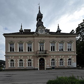
Pyhra (German pronunciation: [ˈpyːʁa] ) is a town with 3286 inhabitants in the district of Sankt Pölten-Land in Lower Austria, Austria.

Contents

Geography

Pyhra is located in the hill country of the Mostviertel in Lower Austria, near the city St. Pölten. The biggest mountain is the Amerlingkogel (628 m).

The area is 66.73 square kilometers big. 40.04 per cent of the area is wooded.

Districts

Districts are Adeldorf, Aigen, Atzling, Auern, Baumgarten, Blindorf, Brunn, Ebersreith, Egelsee, Fahra, Gattring-Raking, Getzersdorf, Heuberg, Hinterholz, Hummelberg bei Hinterholz, Kirchweg, Nützling, Oberburbach, Obergrub, Oberloitzenberg, Obertiefenbach, Perersdorf, Perschenegg, Pyhra, Reichenhag, Reichgrüben, Schauching, Schnabling, Steinbach, Unterburbach, Unterloitzenberg, Wald, Weinzettl, Wieden, Windhag, Zell and Zuleithen.

Neighbour municipalities

Pyhra borders Böheimkirchen in the northeast, Kasten by Böheimkirchen and Michelbach in the east, St. Veit on the Gölsen in the south, Wilhelmsburg in the southwest, and St. Pölten in the west and northwest.

Schools

NÖ Landeskindergarten, Volksschule Pyhra, Europa-Hauptschule Pyhra, Landwirtschaftliche Fachschule Pyhra and the music school of the Perschlingtal.

Related Research Articles

<span class="mw-page-title-main">Pressbaum</span> Municipality in Lower Austria, Austria

Pressbaum is a town in the district of St. Pölten-Land in the Austrian state of Lower Austria.

Kirchstetten is a town in district of Sankt Pölten-Land in the Austrian state of Lower Austria.

Bezirk St. Pölten is a district of the state of Lower Austria in Austria. It completely surrounds the city of St. Pölten, which exists as a separate entity and borders Vienna to the west.

<span class="mw-page-title-main">Frankenfels</span> Municipality in Lower Austria, Austria

Frankenfels is a market town with 1956 inhabitants (2019) in St. Pölten-Land which is a district of the state of Lower Austria, Austria.

<span class="mw-page-title-main">Gnadendorf</span> Municipality in Lower Austria, Austria

Gnadendorf is a town in the district of Mistelbach in the Austrian state of Lower Austria.

<span class="mw-page-title-main">Asperhofen</span> Municipality in Lower Austria, Austria

Asperhofen is a town in the district of Sankt Pölten-Land in the Austrian state of Lower Austria.

Böheimkirchen is a town in the district of Sankt Pölten-Land in the Austrian state of Lower Austria.

<span class="mw-page-title-main">Herzogenburg</span> Municipality in Lower Austria, Austria

Herzogenburg is a town in the district of Sankt Pölten-Land in the Austrian state of Lower Austria.

<span class="mw-page-title-main">Inzersdorf-Getzersdorf</span> Municipality in Lower Austria, Austria

Inzersdorf-Getzersdorf is a town in the district of Sankt Pölten-Land in the Austrian state of Lower Austria.

Kasten bei Böheimkirchen is a town in the district of Sankt Pölten-Land in the Austrian state of Lower Austria.

<span class="mw-page-title-main">Loich</span> Municipality in Lower Austria, Austria

Loich is a small village in the district of Sankt Pölten-Land in the Austrian state of Lower Austria.

Markersdorf-Haindorf is a town in the district of Sankt Pölten-Land in the Austrian state of Lower Austria.

<span class="mw-page-title-main">Neidling</span> Municipality in Lower Austria, Austria

Neidling is a town in the district of Sankt Pölten-Land in the Austrian state of Lower Austria.

<span class="mw-page-title-main">Ober-Grafendorf</span> Municipality in Lower Austria, Austria

Ober-Grafendorf is a municipality in the district of Sankt Pölten-Land in the Austrian state of Lower Austria.

<span class="mw-page-title-main">Stössing</span> Municipality in Lower Austria, Austria

Stössing is a municipality in the district of Sankt Pölten-Land in the Austrian state of Lower Austria.

<span class="mw-page-title-main">Wilhelmsburg, Austria</span> Municipality in Lower Austria, Austria

Wilhelmsburg is a municipality in the district of Sankt Pölten-Land District in the Austrian state of Lower Austria.

<span class="mw-page-title-main">Wölbling</span> Municipality in Lower Austria, Austria

Wölbling is a municipality in the district of Sankt Pölten-Land in the Austrian state of Lower Austria.

<span class="mw-page-title-main">Gablitz</span> Municipality in Lower Austria, Austria

Gablitz is a municipality in the district of St. Pölten-Land in the Austrian state of Lower Austria.

<span class="mw-page-title-main">Tullnerbach</span> Municipality in Lower Austria, Austria

Tullnerbach is a municipality in the district of St. Pölten-Land in the Austrian state of Lower Austria. It was here in 1901 that Wilhelm Kress failed at his attempt of motorized seaplane flight on the Wienerwaldsee. The town belonged to Wien-Umgebung which was dissolved in 2016.

<span class="mw-page-title-main">Wolfsgraben</span> Municipality in Lower Austria, Austria

Wolfsgraben is a municipality in the district of St. Pölten in the Austrian state of Lower Austria.

References

  1. "Dauersiedlungsraum der Gemeinden Politischen Bezirke und Bundesländer - Gebietsstand 1.1.2018". Statistics Austria. Retrieved 10 March 2019.
  2. "Einwohnerzahl 1.1.2018 nach Gemeinden mit Status, Gebietsstand 1.1.2018". Statistics Austria. Retrieved 9 March 2019.