
Geotechnical engineering, also known as geotechnics, is the branch of civil engineering concerned with the engineering behavior of earth materials. It uses the principles of soil mechanics and rock mechanics to solve its engineering problems. It also relies on knowledge of geology, hydrology, geophysics, and other related sciences.

Soil mechanics is a branch of soil physics and applied mechanics that describes the behavior of soils. It differs from fluid mechanics and solid mechanics in the sense that soils consist of a heterogeneous mixture of fluids and particles but soil may also contain organic solids and other matter. Along with rock mechanics, soil mechanics provides the theoretical basis for analysis in geotechnical engineering, a subdiscipline of civil engineering, and engineering geology, a subdiscipline of geology. Soil mechanics is used to analyze the deformations of and flow of fluids within natural and man-made structures that are supported on or made of soil, or structures that are buried in soils. Example applications are building and bridge foundations, retaining walls, dams, and buried pipeline systems. Principles of soil mechanics are also used in related disciplines such as geophysical engineering, coastal engineering, agricultural engineering, and hydrology.

Slope stability refers to the condition of inclined soil or rock slopes to withstand or undergo movement; the opposite condition is called slope instability or slope failure. The stability condition of slopes is a subject of study and research in soil mechanics, geotechnical engineering, and engineering geology. Analyses are generally aimed at understanding the causes of an occurred slope failure, or the factors that can potentially trigger a slope movement, resulting in a landslide, as well as at preventing the initiation of such movement, slowing it down or arresting it through mitigation countermeasures.
Rock mass classification systems are used for various engineering design and stability analysis. These are based on empirical relations between rock mass parameters and engineering applications, such as tunnels, slopes, foundations, and excavatability. The first rock mass classification system in geotechnical engineering was proposed in 1946 for tunnels with steel set support.
Rock Structure Rating (RSR) is a quantitative method for describing quality of a rock mass and appropriate ground support, in particular, for steel-rib support, developed by Wickham, Tiedemann and Skinner.

Rock mechanics is a theoretical and applied science of the mechanical behavior of rocks and rock masses.
Landslide mitigation refers to several human-made activities on slopes with the goal of lessening the effect of landslides. Landslides can be triggered by many, sometimes concomitant causes. In addition to shallow erosion or reduction of shear strength caused by seasonal rainfall, landslides may be triggered by anthropic activities, such as adding excessive weight above the slope, digging at mid-slope or at the foot of the slope. Often, individual phenomena join to generate instability over time, which often does not allow a reconstruction of the evolution of a particular landslide. Therefore, landslide hazard mitigation measures are not generally classified according to the phenomenon that might cause a landslide. Instead, they are classified by the sort of slope stabilization method used:
Slope mass rating (SMR) is a rock mass classification scheme developed by Manuel Romana to describe the strength of an individual rock outcrop or slope. The system is founded upon the more widely used RMR scheme, which is modified with quantitative guidelines to the rate the influence of adverse joint orientations.
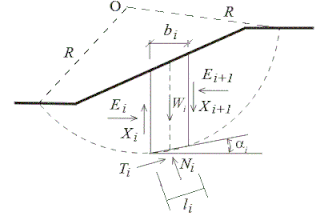
Slope stability analysis is a static or dynamic, analytical or empirical method to evaluate the stability of slopes of soil- and rock-fill dams, embankments, excavated slopes, and natural slopes in soil and rock. It is performed to assess the safe design of a human-made or natural slopes and the equilibrium conditions. Slope stability is the resistance of inclined surface to failure by sliding or collapsing. The main objectives of slope stability analysis are finding endangered areas, investigation of potential failure mechanisms, determination of the slope sensitivity to different triggering mechanisms, designing of optimal slopes with regard to safety, reliability and economics, and designing possible remedial measures, e.g. barriers and stabilization.
The Geological Strength Index (GSI) system, proposed in 1994 by Evert Hoek, is used for the estimation of the rock mass strength and the rock mass deformation modulus.
Core recovery parameters describe the quality of core recovered from a borehole.
In geotechnical engineering, a discontinuity is a plane or surface that marks a change in physical or chemical characteristics in a soil or rock mass. A discontinuity can be, for example, a bedding, schistosity, foliation, joint, cleavage, fracture, fissure, crack, or fault plane. A division is made between mechanical and integral discontinuities. Discontinuities may occur multiple times with broadly the same mechanical characteristics in a discontinuity set, or may be a single discontinuity. A discontinuity makes a soil or rock mass anisotropic.
Within geotechnical engineering, Laubscher developed the Mining Rock Mass Rating (MRMR) system by modifying the Rock Mass Rating (RMR) system of Z. T. Bieniawski. In the MRMR system the stability and support are determined with the following equations:
In geotechnical engineering and contact mechanics the term asperity is used to refer to individual features of unevenness (roughness) of the surface of a discontinuity, grain, or particle with heights in the range from approximately 0.1 mm to the order of metres. Below the asperity level, surface interactions are normally considered to be a material property, arising from mechanisms of adhesion and repulsion at the atomic scale.
The Q-system for rock mass classification is developed by Barton, Lien, and Lunde. It expresses the quality of the rock mass in the so-called Q-value, on which design are based and support recommendations for underground excavations.
The shear strength of a discontinuity in a soil or rock mass may have a strong impact on the mechanical behavior of a soil or rock mass. The shear strength of a discontinuity is often considerably lower than the shear strength of the blocks of intact material in between the discontinuities, and therefore influences, for example, tunnel, foundation, or slope engineering, but also the stability of natural slopes. Many slopes, natural and man-made, fail due to a low shear strength of discontinuities in the soil or rock mass in the slope. The deformation characteristics of a soil or rock mass are also influenced by the shear strength of the discontinuities. For example, the modulus of deformation is reduced, and the deformation becomes plastic rather than elastic. This may cause, for example, larger settlement of foundations, which is also permanent even if the load is only temporary. Furthermore, the shear strength of discontinuities influences the stress distribution in a soil or rock mass.
The sliding criterion (discontinuity) is a tool to estimate easily the shear strength properties of a discontinuity in a rock mass based on visual and tactile characterization of the discontinuity. The shear strength of a discontinuity is important in, for example, tunnel, foundation, or slope engineering, but also stability of natural slopes is often governed by the shear strength along discontinuities.
Geological structure measurement by LiDAR technology is a remote sensing method applied in structural geology. It enables monitoring and characterisation of rock bodies. This method's typical use is to acquire high resolution structural and deformational data for identifying geological hazards risk, such as assessing rockfall risks or studying pre-earthquake deformation signs.

George Ter-Stepanian was a Soviet Armenian scientist in the field of soil mechanics and engineering geology, one of the founders of the landslide studies, and the originator of the theories of the depth creep of slopes, the structural composition of post-ice-age clay and suspension pressure acting against filtration. Ter-Stepanian was a member of the National Academy of Sciences of Armenia.

Yossef H. Hatzor is an Israeli Professor of Earth and Environmental Sciences at the Ben-Gurion University of the Negev (BGU). He holds the Dr. Sam and Edna Lemkin Chair in Rock mechanics, and a joint appointment with the Department of Civil and Environmental Engineering at BGU.


