Quapaw Indian Agency

Last updated

The Quapaw Indian Agency was a territory that included parts of the present-day Oklahoma counties of Ottawa and Delaware. Established in the late 1830s as part of lands allocated to the Cherokee Nation, this area was later leased by the federal government and known as the Leased District. The area that became known as the Quapaw Agency Lands contained 220,000 acres and was located in the northeastern corner of Oklahoma where that state adjoins Missouri and Kansas.

Contents

After the Civil War, the Cherokee were forced to cede the land and the US assigned it to several other tribes. This area was settled prior to 1874 by 24 Indian groups. These range from full Indian tribes down to the remnants of several larger Indian groups whose main body settled elsewhere.

The agency was disbanded in 1890 by the Oklahoma Organic Act, which was designed to extinguish tribal communal land claims. The land was attached to an Indian Territory prior to passage of the Dawes Act and distribution of plots to individual households. Another Indian reserve, the Miami Indian Agency based in Miami, Oklahoma was disbanded at the same time. All Native American claims were extinguished prior to Oklahoma's admission to statehood in the 20th century.

History

Among the tribes who were forcibly removed to these lands from east of the Mississippi River were people of the Algonquin and the Iroquois tribes. In the early colonial period, at the time of Samuel de Champlain, they were great enemies. Here also, plowing and harvesting their fields together and sharing each other's native ceremonials, was a tribe of the mighty Siouan nation, as well as one of the Lupuamian[ clarification needed ] nation.[ dubious ] Within the memories of their grandfathers, these old and powerful tribes had owned many hundreds of thousands of acres in Ohio, Illinois, Indiana, Arkansas, Oklahoma and Oregon.

Since early territorial days of 1867, a federal Indian agency operated to manage the relationship between the federal government and these various tribes, supervising provision of annuities and supplies, for instance. But not all of the business handled by the agent was tribal business. The Indian Agent often found acted as a mediator in settling neighborhood and family disputes, as well.

Because the land was originally given to the Quapaw Tribe, this area was renamed in the 19th century as the Quapaw Agency Lands. Prior to this, it and other nearby areas had been known as the Neosho Indian Agency, the Shawnee Indian Agency, and the Seneca Indian Agency, representing major tribes settled in the area. The agency was originally located four miles west of Seneca, Missouri, and later moved to Wyandotte in the Indian Territory as the Native Americans were settled there.

In 1873, 153 surviving members of a Modoc band formerly headed by Captain Jack (Kintpuash), were relocated here from northern California after their defeat. Kintpuash was hanged, executed by the US Army for charges of war crimes. The Modoc were long colocated with the Shawnee on their reserve at what became known as the Quapaw Agency. The agency did not receive sufficient supplies and the Modoc suffered greatly in their first months.

In 1920, two agencies were established; the Seneca and Quapaw. In 1922 they were combined again and became the Quapaw Agency.

Due to the proximity of their reservations, there were many intermarriages among members of the tribes in this northeast area. Several tribes eventually merged their governments. Some of the individual listings below will lead the researcher to the federally recognized tribal names by which these nations are known today.

Primary Tribes

The Primary tribes of the Quapaw Indian Agency were: [1]

Other Resources

Daniel B. Dyer Collection

John D. Miles, a Quaker, was employed as the Indian Agent from 1872 to 1884. Daniel B. Dyer was employed as Indian agent at the Quapaw Indian Agency from 1881 to 1884. [2] The Daniel B. Dyer Collection located at The University of Kansas Libraries, Kenneth Spencer Research Library includes photographs of Quapaw and Osage Indians and the Quapaw and Modoc Methodist Mission. The collection also contains picture post cards of scenes in Oklahoma and Indian portraits from 1889 to 1908. A part of the peace policy of President Grant was to assign Quakers as Indian Agents.

National Archives Southwest Region

Many records of the Quapaw Agency are in the National Archives Southwest Region (Ft. Worth)[3], including:

Census records—Eastern Shawnee, 1882–1940 Miami, 1888–1940 Modoc, 1885–1890 Nez Perce, n.d. Ottawa, 1883–1888 Peoria, 1883–1959 Quapaw, 1885–1933, with updates to 1955 Seneca, 1877–1940 Wyandot, 1871–1956 Death rolls, 1931–1935 Birth rolls, 1931–1935 Miami applications and rejected applications, 1972–1973 Land and property records, 1873–1959 School records, 1882–1940 And many other administrative files and correspondence

Letters received by the Office of Indian Affairs from the Quapaw Agency, 1871–1880, have been microfilmed by the National Archives as part of their Microcopy Number M234, Rolls 703-713[4]. Copies are available at the National Archives and at the Family History Library and its family history centers on their microfilm roll numbers 1661433 thru 1661443.

Reports of Inspection of the Field Jurisdictions of the Office of Indian Affairs, 1873-1900 have been microfilmed by the National Archives as part of Microcopy Number M1070. The reports for Quapaw Agency, 1874–1898, are on rolls 41-42 of that Microcopy set[5]. Copies are available at the National Archives, their Regional Archives, and at the Family History Library and its family history centers (their microfilm roll numbers 1617714-1617715).

Microfilm copies of ...Narrative and Statistical Reports... for the Quapaw Agency, 1921–1938, are included in National Archives Microcopy M1011, Rolls 111-112[6], available in the National Archives system and in the collections of the Family History Library in Salt Lake City, beginning with their microfilm numbers 1724329-1724330.

Annual Indian Census Rolls were taken at this agency for 1885–1900 and 1922 thru 1939. These rolls have been microfilmed by the National Archives as part of their Microcopy Number M595, rolls 411-416[7]. Copies of these records are also available at the National Archives, their Regional Archives, and at the Family History Library and its family history centers (their microfilm roll numbers 581405-581410). These census rolls are also available online at Ancestry.com's subscription web site.

Quapaw Agency Records 1872-1948 (school, census, vital, allotment, and annuity) FHL Collection, film: 1204600 first film of a collection.

See also

Related Research Articles

<span class="mw-page-title-main">Indian Territory</span> Evolving land area set aside by the United States Government for the relocation of Native Americans

The Indian Territory and the Indian Territories are terms that generally described an evolving land area set aside by the United States Government for the relocation of Native Americans who held aboriginal title to their land as a sovereign independent state. In general, the tribes ceded land they occupied in exchange for land grants in 1803. The concept of an Indian Territory was an outcome of the US federal government's 18th- and 19th-century policy of Indian removal. After the American Civil War (1861–1865), the policy of the US government was one of assimilation.

<span class="mw-page-title-main">Ottawa County, Oklahoma</span> County in Oklahoma, United States

Ottawa County is a county located in the northeastern corner of the U.S. state of Oklahoma. As of the 2020 census, the population was 30,285. Its county seat is Miami. The county was named for the Ottawa Tribe of Oklahoma. It is also the location of the federally recognized Modoc Nation and the Quapaw Nation, which is based in Quapaw.

<span class="mw-page-title-main">Miami, Oklahoma</span> City in Oklahoma, United States

Miami is a city in and county seat of Ottawa County, Oklahoma, United States, founded in 1891. Lead and zinc mining were established by 1918, causing the area's economy to boom.

<span class="mw-page-title-main">Modoc War</span> 1872–73 conflict between the Native American Modoc people and the U.S. Army

The Modoc War, or the Modoc Campaign, was an armed conflict between the Native American Modoc people and the United States Army in northeastern California and southeastern Oregon from 1872 to 1873. Eadweard Muybridge photographed the early part of the US Army's campaign.

<span class="mw-page-title-main">Modoc people</span> Native American people originally from northern California and Oregon

The Modoc are a Native American people who originally lived in the area which is now northeastern California and central Southern Oregon. They are currently divided between Oregon and Oklahoma and are enrolled in either of two federally recognized tribes, the Klamath Tribes in Oregon and the Modoc Tribe of Oklahoma, now known as the Modoc Nation.
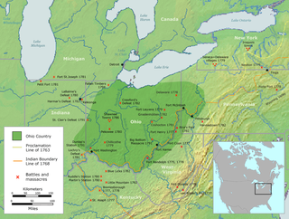
<span class="mw-page-title-main">Ohio Country</span> Historical region in North America

The Ohio Country was a name used in the mid- to late 18th century for a region of North America west of the Appalachian Mountains and north of the upper Ohio and Allegheny rivers, extending to Lake Erie. The area encompassed roughly northwestern West Virginia, Western Pennsylvania, all of the present-day state of Ohio, and a wedge of southeastern Indiana.

<span class="mw-page-title-main">Shawnee</span> Indigenous peoples of the Northeastern Woodlands, based in Oklahoma

The Shawnee are an Algonquian-speaking indigenous people of the Northeastern Woodlands. In the 17th century they lived in Pennsylvania, and in the 18th century they were in Pennsylvania, Ohio, and Indiana with some bands in Kentucky and Alabama. By the 19th century, they were forcibly removed to Missouri, Kansas, Texas, and ultimately Indian Territory, which became Oklahoma under the 1830 Indian Removal Act.

<span class="mw-page-title-main">Peoria people</span> Native American ethnicity

The Peoria, also Peouaroua, are a Native American people. They are enrolled in the federally recognized Peoria Tribe of Indians of Oklahoma headquartered in Miami, Oklahoma.

<span class="mw-page-title-main">Wyandotte Nation</span> A federally recognized Native American tribe in Oklahoma

The Wyandotte Nation is a federally recognized Native American tribe in northeastern Oklahoma. They are descendants of the Wendat Confederacy and Native Americans with territory near Georgian Bay and Lake Huron. Under pressure from Haudenosaunee and other tribes, then from European settlers and the United States government, the tribe gradually moved south and west to Michigan, Ohio, Kansas, and finally Oklahoma in the United States.

<span class="mw-page-title-main">Quapaw</span> Native American tribe

The Quapaw people are a tribe of Native Americans that coalesced in what is known as the Midwest and Ohio Valley of the present-day United States. The Dhegiha Siouan-speaking tribe historically migrated from the Ohio Valley area to the west side of the Mississippi River and resettled in what is now the state of Arkansas; their name for themselves refers to this migration and to traveling downriver.

<span class="mw-page-title-main">Ottawa Tribe of Oklahoma</span>

The Ottawa Tribe of Oklahoma is one of four federally recognized Native American tribes of Odawa people in the United States. Its Algonquian-speaking ancestors had migrated gradually from the Atlantic coast and Great Lakes areas, reaching what are now the states of Michigan and Ohio in the 18th century. In the late 1830s the United States removed the Ottawa to west of the Mississippi River, first to Iowa, then to Kansas in what was Indian Territory. Following the Civil War, in 1867 they sold their land in Kansas to move again, to purchase land in another section of Indian Territory, in what would become northeast Oklahoma. They were authorized by Congress to buy land from the Quapaw, the predominant tribe in this area.

<span class="mw-page-title-main">Absentee Shawnee Tribe of Indians</span> American Indian tribe in Oklahoma, United States

The Absentee Shawnee Tribe of Indians of Oklahoma is one of three federally recognized tribes of Shawnee people. Historically residing in what became organized as the upper part of the Eastern United States, the original Shawnee lived in the large territory now made up of Pennsylvania, Kentucky, Tennessee, Ohio, Indiana, Illinois, and neighboring states. In total, they occupied and traveled through lands ranging from Canada to Florida, and from the Mississippi River to the eastern continental coast.

<span class="mw-page-title-main">Seneca–Cayuga Nation</span> Federally-recognized Native American tribe

The Seneca–Cayuga Nation is one of three federally recognized tribes of Seneca people in the United States. It includes the Cayuga people and is based in Oklahoma, United States. The tribe had more than 5,000 people in 2011. They have a tribal jurisdictional area in the northeast corner of Oklahoma and are headquartered in Grove. They are descended from Iroquoian peoples who had relocated to Ohio from New York in the mid-18th century.

<span class="mw-page-title-main">Modoc Nation</span>

The Modoc Nation is a federally recognized tribe of Modoc people, located in Ottawa County in the northeast corner of Oklahoma and Modoc and Siskiyou counties in northeast California. The smallest tribe in the state, they are descendants of Captain Jack's band of Modoc people, removed in 1873 after the Modoc Wars from their traditional territory in northern California and southern Oregon. They were exiled to the Quapaw Agency in Indian Territory, where they were colocated with the Shawnee people from east of the Mississippi River.

<span class="mw-page-title-main">Vehicle registration plates of Native American tribes in the United States</span> Native American tribe vehicle license plates

Several Native American tribes within the United States register motor vehicles and issue license plates to those vehicles.

<span class="mw-page-title-main">Eastern Shawnee Tribe of Oklahoma</span>

The Eastern Shawnee Tribe of Oklahoma is one of three federally recognized Shawnee tribes. They are located in Oklahoma and Missouri.

<span class="mw-page-title-main">Oklahoma Tribal Statistical Area</span> Statistical entity

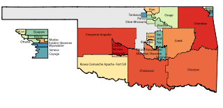
Oklahoma Tribal Statistical Area is a statistical entity identified and delineated by federally recognized American Indian tribes in Oklahoma as part of the U.S. Census Bureau's 2010 Census and ongoing American Community Survey. Many of these areas are also designated Tribal Jurisdictional Areas, areas within which tribes will provide government services and assert other forms of government authority. They differ from standard reservations, such as the Osage Nation of Oklahoma, in that allotment was broken up and as a consequence their residents are a mix of native and non-native people, with only tribal members subject to the tribal government. At least five of these areas, those of the so-called five civilized tribes of Cherokee, Choctaw, Chickasaw, Creek and Seminole, which cover 43% of the area of the state, are recognized as reservations by federal treaty, and thus not subject to state law or jurisdiction for tribal members.

On the eve of the American Civil War in 1861, a significant number of Indigenous peoples of the Americas had been relocated from the Southeastern United States to Indian Territory, west of the Mississippi. The inhabitants of the eastern part of the Indian Territory, the Five Civilized Tribes, were suzerain nations with established tribal governments, well established cultures, and legal systems that allowed for slavery. Before European Contact these tribes were generally matriarchial societies, with agriculture being the primary economic pursuit. The bulk of the tribes lived in towns with planned streets, residential and public areas. The people were ruled by complex hereditary chiefdoms of varying size and complexity with high levels of military organization.

<span class="mw-page-title-main">Seneca Indian School</span>

The Seneca Indian School was a Native American boarding school located in Wyandotte, Oklahoma. Initially founded for Seneca, Shawnee, and Wyandotte children, in later years it had many Cherokee students. The school operated from 1872 to 1980.

References

  1. "The Quapaw Agency Lands Of Indian Territory, Hosted by Ancestry.com" . Retrieved 2012-02-10.
  2. [note this dates appear to different from the newspaper accounts1]

Coordinates: 36°36′N94°48′W / 36.6°N 94.8°W / 36.6; -94.8