Quebeck, Tennessee

Last updated

Quebeck, Tennessee
Quebeck-from-community-center-tn1.jpg
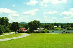
View from the Quebeck Community Center
USA Tennessee location map.svg
Red pog.svg
Quebeck, Tennessee
Usa edcp location map.svg
Red pog.svg
Quebeck, Tennessee
Coordinates: 35°49′00″N85°34′01″W / 35.81667°N 85.56694°W / 35.81667; -85.56694
Country United States
State Tennessee
County White
Elevation
[1]
902 ft (275 m)
Time zone UTC-6 (Central (CST))
  Summer (DST) UTC-5 (CDT)
ZIP code
38579
Area code 931
GNIS feature ID1298751 [1]

Quebeck is an unincorporated community in White County, Tennessee, United States. It is located just off U.S. Route 70, southwest of Doyle and northeast of Rock Island, and roughly adjacent to Walling. Quebeck had a post office with ZIP code 38579. [2]

The community was founded in the late 1880s by J.S. Cooper, a local sawmill owner. He named it for the Canadian province of Quebec, having been inspired by his travels there. [3]

Related Research Articles

<span class="mw-page-title-main">ZIP Code</span> Numeric postal code used in the United States and its territories

A ZIP Code is a system of postal codes used by the United States Postal Service (USPS). The term ZIP was chosen to suggest that the mail travels more efficiently and quickly when senders use the code in the postal address.

<span class="mw-page-title-main">Georgetown, Tennessee</span> Unincorporated community in Tennessee, United States

Georgetown is an unincorporated community at the junction of Bradley, Hamilton, and Meigs counties, Tennessee. The community is located along State Route 60 near its intersection with State Route 58.

<span class="mw-page-title-main">Clairfield, Tennessee</span> Unincorporated community in Tennessee, United States

Clairfield is an unincorporated community in Claiborne County, Tennessee, United States. It is located in the upper Clearfork Valley in the Cumberland Mountains of northeastern Tennessee. It is the site of a post office, assigned ZIP code 37715. The population of the Zip Code Tabulation Area corresponding to Clairfield's ZIP code was 1,002 as of the 2000 Census.

<span class="mw-page-title-main">Eva, Tennessee</span> CDP in Tennessee, United States

Eva is an unincorporated community and census-designated place (CDP) in Benton County, Tennessee, on the western shore of the Kentucky Lake impoundment of the Tennessee River. It is the site of Nathan Bedford Forrest State Park. As of the 2010 census, its population was 293. The ZIP Code Tabulation Area for the ZIP code (38333) that serves Eva had a population of 574 as of the 2000 U.S. Census, when Eva was not yet a CDP. Eva is centered on the junction of State Route 191, which connects the community to Nathan Bedford Forrest State Park to the north and the town of Camden to the south, and Eva Beach Road, which stretches from the center of the community to its beach along Kentucky Lake.

<span class="mw-page-title-main">Ocoee, Tennessee</span> Unincorporated community in Polk County, Tennessee

Ocoee is an unincorporated community in Polk County, Tennessee, United States and named after the Cherokee settlement located in the area. Ocoee had a post office until it was severely damaged by a tornado. It still retains its own ZIP code 37361.

<span class="mw-page-title-main">Walling, Tennessee</span> Unincorporated community in Tennessee, United States

Walling is an unincorporated community in White County, Tennessee, United States. It lies along the Caney Fork southwest of Doyle, and east of Rock Island State Park. Tennessee State Route 136 passes through the community. Walling has a post office with ZIP code 38587.

<span class="mw-page-title-main">Turtletown, Tennessee</span> Unincorporated community in Tennessee, United States

Turtletown is an unincorporated community in Polk County, Tennessee, United States. Turtletown is located on Tennessee State Route 68 6.5 miles (10.5 km) north-northeast of Ducktown. Turtletown is in a primarily mountainous terrain, covered in forests except for areas cleared by farmers, ponds, or roads. Turtletown has a post office with ZIP code 37391. Turtletown's borders, however, in the eyes of some are disputed. According to one, parts of it are known as Dogtown, which appears on a few local maps. However, to others, it is simply all Turtletown and Dogtown does not exist. The only known map that contains this is the USGS map of the area, and a U.S. Forest Service map. There is an abandoned school, Turtletown School, across the street from the Post Office.

Delano is an unincorporated community in Polk County, Tennessee, United States. It is located near the junction of U.S. Route 411, Tennessee State Route 30 and Tennessee State Route 163 4.3 miles (6.9 km) south-southwest of Etowah. Delano has a post office with ZIP code 37325, which opened on August 14, 1909.

Pleasant Shade is an unincorporated community in northern Smith County, Tennessee, United States. It has a post office, assigned zip code 37145. The community is centered along Tennessee State Route 80.

<span class="mw-page-title-main">Evensville, Tennessee</span> Unincorporated community in Tennessee, United States

Evensville is an unincorporated community in Rhea County, Tennessee, United States. In 2020 the population was 2,624. Evensville is located along U.S. Route 27 5.8 miles (9.3 km) northeast of Dayton. Evensville has a post office with ZIP code 37332. Rhea County High School is located in Evensville.

<span class="mw-page-title-main">Smartt, Tennessee</span> Unincorporated community in Tennessee, United States

Smartt is an unincorporated community in Warren County, Tennessee, United States. Smartt is located along Tennessee State Route 55 and the Caney Fork and Western Railroad 4.5 miles (7.2 km) southwest of McMinnville. Smartt has a post office with ZIP code 37378.

<span class="mw-page-title-main">Lancing, Tennessee</span> Unincorporated community in Tennessee, United States

Lancing is an unincorporated community in Morgan County, Tennessee, United States. Lancing is located along Tennessee State Route 62 and the Norfolk Southern Railway 3.35 miles (5.39 km) west-northwest of Wartburg, and northeast of the Catoosa Wildlife Management Area. Lancing has a post office with ZIP code 37770.

Holladay is an unincorporated community and census-designated place in Benton and Decatur counties in the U.S. state of Tennessee. Holladay is located along Tennessee State Route 192 13.3 miles (21.4 km) south-southwest of Camden. Another portion of the community is located at the intersection of I-40 and US 641/SR 69. Holladay has a post office with ZIP code 38341, which opened on February 23, 1887.

<span class="mw-page-title-main">Beechgrove, Coffee County, Tennessee</span> Unincorporated community in Tennessee, United States

Beechgrove, also known as Beech Grove, is an unincorporated community in Coffee County, Tennessee, United States. Beechgrove is located in northwestern Coffee County at the junction of Interstate 24, U.S. Route 41, and State Route 64. Beechgrove has a post office with ZIP code 37018.

<span class="mw-page-title-main">Christiana, Tennessee</span> Census-designated place in Tennessee, United States

Christiana is an unincorporated community and census-designated place in Rutherford County, Tennessee, United States. It has a post office, with ZIP code 37037. Christiana Middle School is located in the community. Both U.S. Route 231 and Tennessee State Route 269 pass through the community.

<span class="mw-page-title-main">Kelso, Tennessee</span> Unincorporated community in Tennessee, United States

Kelso is an unincorporated community in Lincoln County, Tennessee, United States. Kelso is located along U.S. Route 64 6 miles (9.7 km) east-southeast of Fayetteville. Kelso has a post office with ZIP code 37348. The community is home to the original Benjamin Prichard's distillery.

<span class="mw-page-title-main">Flintville, Tennessee</span> Unincorporated community in Lincoln County, Tennessee

Flintville is an unincorporated community in Lincoln County, Tennessee, United States. As of the 2010 census, its population was 627. Flintville is located approximately 10.5 miles (16.9 km) southeast of Fayetteville along Tennessee State Route 275 highway.

<span class="mw-page-title-main">Pelham, Tennessee</span> Census-designated place in Tennessee, United States

Pelham is an unincorporated community and census-designated place (CDP) in Grundy County, Tennessee, United States. As of the 2010 census, its population was 403. Pelham is located at the junction of U.S. Route 41, State Route 2, and State Route 50 near the base of the Cumberland Plateau, 5.35 miles (8.61 km) north-northwest of Monteagle. Pelham has a post office with ZIP code 37366, which opened on April 4, 1832.

McDonald is an unincorporated community and census-designated place (CDP) in Bradley County, Tennessee, United States. McDonald is located along U.S. Route 11 and U.S. Route 64 6.8 miles (10.9 km) west-southwest of Cleveland. McDonald has a post office with ZIP code 37353.

Lynn Garden is a community and neighborhood in Kingsport, Tennessee.

References