Queropalca District

Last updated
Queropalca
Qirupallqa
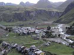
District

C.P. Queropalca 02188.JPG

Queropalca
Country Flag of Peru.svg  Peru
Region Huánuco
Province Lauricocha
Founded May 12, 1962
Capital Queropalca
Government
   Mayor Carlos Enrique Zambrano Santillan
Area
  Total 131.15 km2 (50.64 sq mi)
Elevation 3,831 m (12,569 ft)
Population (2005 census)
  Total 849
  Density 6.5/km2 (17/sq mi)
Time zone PET (UTC-5)
UBIGEO 101004

Queropalca District is one of seven districts of the province Lauricocha in Peru. [1]

Districts of Peru third level administrative subdivision of Peru

The districts of Peru are the third-level country subdivisions of Peru. They are subdivisions of the provinces, which in turn are subdivisions of the larger regions or departments. There are 1,838 districts in total.

Lauricocha Province Province in Huánuco, Peru

Lauricocha Province is one of 11 provinces of the Huánuco Region in Peru. The capital of the province is Jesús.

Peru republic in South America

Peru, officially the Republic of Peru, is a country in western South America. It is bordered in the north by Ecuador and Colombia, in the east by Brazil, in the southeast by Bolivia, in the south by Chile, and in the west by the Pacific Ocean. Peru is a megadiverse country with habitats ranging from the arid plains of the Pacific coastal region in the west to the peaks of the Andes mountains vertically extending from the north to the southeast of the country to the tropical Amazon Basin rainforest in the east with the Amazon river.

Contents

Geography

The Waywash mountain range traverses the district. The highest peak of the district is Yerupaja at 6,635 m (21,768 ft) which is also the highest elevation of the range. Other mountains are listed below: [2]

Chawpi Hanka (Ancash-Huánuco) mountain in Peru

Chawpi Hanka is a mountain in the Andes of Peru, about 4,800 m (15,748 ft) high. It is situated in the Ancash Region, Bolognesi Province, in the districts of Huallanca and Huasta, and in the Huánuco Region Lauricocha Province, Queropalca District. It lies on a ridge north of the Waywash mountain range.

See also

Related Research Articles

Department of Huánuco Region in 11 provinces and 76 districts, Peru

Huánuco is a department in central Peru. It is bordered by the La Libertad, San Martín, Loreto and Ucayali regions in the north, the Ucayali Region in the east, the Pasco Region in the south and the Lima and Ancash regions in the west. Its capital is the city Huánuco.

Lauricocha is a small parish in the central Andean highlands of Perú.

Canta Province Province in Lima, Peru

Canta Province is a province in the Lima Region of Peru, situated approximately 105 kilometres (65 mi) to the northeast of the Peruvian capital, Lima.

Yarowilca Province Province in Huánuco, Peru

The Yarowilca Province is the smallest of eleven provinces of the Huánuco Region in Peru. The capital of this province is Chavinillo.

Ambo Province Province in Huánuco, Peru

The Ambo Province is one of eleven provinces of the Huánuco Region in Peru. The capital of this province is the city of Huacrachuco.

Ticlacayán District District in Pasco, Peru

Ticlacayán District is one of thirteen districts of the Pasco Province in the Pasco Region of Peru. Its seat is Ticlacayán.

Cajatambo District District in Lima, Peru

Cajatambo or Qaqatampu (Quechua) is one of five districts of the province Cajatambo in Peru.

Morococha District District in Junín, Peru

Morococha District is one of ten districts of the province Yauli in Peru.

Carampoma District is one of thirty-two districts of the province Huarochirí in Peru.

San Lorenzo de Quinti District District in Lima, Peru

San Lorenzo de Quinti District is one of thirty-two districts of the province Huarochirí in Peru.

San Mateo District, Huarochirí District in Lima, Peru

San Mateo District is one of thirty-two districts of the province Huarochirí in Peru.

Oyón District District in Lima, Peru

Oyón District is one of six districts of the province Oyón in Peru.

Atavillos Alto District is one of twelve districts of the Huaral Province in Peru.

Baños District is one of seven districts of the province Lauricocha in Peru.

Jesús District is one of seven districts of the province Lauricocha in Peru.

Rondos District is one of seven districts of the province Lauricocha in Peru.

San Francisco de Asís District District in Huánuco, Peru

San Francisco de Asís is one of seven districts of the province Lauricocha in Peru.

San Miguel de Cauri District is one of seven districts of the Lauricocha Province in Peru.

Chuspiccocha (Huánuco)

Chuspiccocha is a mountain at a lake of that name in the Raura mountain range in the Andes of Peru, about 5,000 m (16,000 ft). It is located in the Huánuco Region, Lauricocha Province, Cauri District.

References

  1. (in Spanish) Instituto Nacional de Estadística e Informática. Banco de Información Distrital Archived April 23, 2008, at the Wayback Machine .. Retrieved April 11, 2008.
  2. escale.minedu.gob.pe - UGEL map of the Lauricocha Province (Huánuco Region)

Coordinates: 10°10′45″S76°48′10″W / 10.17917°S 76.80278°W / -10.17917; -76.80278

Geographic coordinate system Coordinate system

A geographic coordinate system is a coordinate system that enables every location on Earth to be specified by a set of numbers, letters or symbols. The coordinates are often chosen such that one of the numbers represents a vertical position and two or three of the numbers represent a horizontal position; alternatively, a geographic position may be expressed in a combined three-dimensional Cartesian vector. A common choice of coordinates is latitude, longitude and elevation. To specify a location on a plane requires a map projection.