National routes in South Africa are a class of trunk roads and freeways which connect major cities. They form the highest category in the South African route numbering scheme, and are designated with route numbers beginning with "N", from N1 to N18. Most segments of the national route network are officially proclaimed National Roads that are maintained by the South African National Roads Agency (SANRAL), but some segments are maintained by provincial or local road authorities.
Regional routes are the third category of road in the South African route numbering scheme. They are designated with the letter "R" followed by a three-digit number. They serve as feeders connecting smaller towns to the national and provincial routes. Designation as a regional road does not necessarily imply any particular size of road; they range from gravel roads to multi-lane freeways.

The R56 is a provincial route in South Africa that connects Middelburg with Pietermaritzburg via Molteno, Maclear and Kokstad. It is co-signed with the N2 between Kokstad and Stafford's Post for 39 kilometres.

The R61 is a long provincial route in South Africa that connects Beaufort West with Port Shepstone via Graaff-Reinet, Komani, Mthatha and Port Edward.

The R75 is a provincial route in Eastern Cape, South Africa that connects Graaff-Reinet with Gqeberha via Despatch, Kariega and Jansenville.
The R337 is a Regional Route in South Africa that connects Cradock and the R329 heading towards Willowmore via Jansenville.
The R401 is a Regional Route in South Africa that connects Hofmeyr with the R61 between Cradock and Bethesdaweg.

George is the second largest city in the Western Cape province of South Africa. The city is a popular holiday and conference centre, as well as the administrative and commercial hub and the seat of the Garden Route District Municipality. It is named after the British Monarch George III.
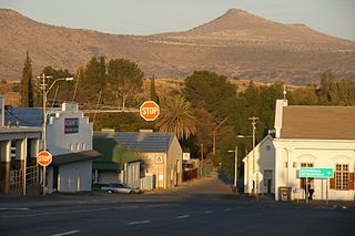
Cradock, officially Nxuba, is a town in the Eastern Cape Province of South Africa, in the upper valley of the Great Fish River, 250 kilometres (160 mi) by road northeast of Port Elizabeth. The town is the administrative seat of the Inxuba Yethemba Local Municipality in the Chris Hani District of the Eastern Cape.

The Nissan R390 GT1 was a racing car built in Atsugi, Japan. It was designed primarily to gain a suitable racing entry in the 24 Hours of Le Mans in 1997 and 1998. It was built to race under the grand touring style rules, requiring a homologated road version to be built. Therefore, the R390 was built originally as road car, then a racing version of the car was developed afterwards. Only one R390 road car was ever built and is stored at Nissan's Zama facility, although one of the race cars was later modified for road use. The road car was claimed to be capable of attaining a top speed of 354 km/h (220 mph). However, this claim has never been proven.
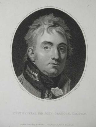
General John Francis Cradock, 1st Baron Howden was a British peer, politician and soldier.

The Outeniqua Mountains, named after the Outeniqua Khoikhoi who lived there, is a mountain range that runs a parallel to the southern coast of South Africa, and forms a continuous range with the Langeberg to the west and the Tsitsikamma Mountains to the east. It was known as Serra de Estrella to the Portuguese. The mountains are part of the Garden Route of South Africa.

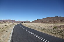
The N10 is a national route in South Africa connecting Gqeberha on the Eastern Cape coast with the Namibian border at Nakop, via Cradock, De Aar and Upington.

Pearston is a small town in the eastern Karoo, in the Eastern Cape province of South Africa. It lies between Graaff-Reinet and Somerset East at the foot of the Coetzeesberge, about 160 kilometres (100 mi) north of Port Elizabeth. It falls within the Blue Crane Route Local Municipality and has a population of approximately 4,500 people.
The R701 is a major regional route in the Free State, South Africa.
The R715 is a Regional Route in Free State, South Africa that connects Springfontein with Bethulie.
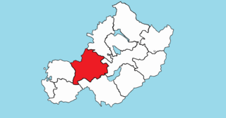
Rathconrath, previously the barony of Rathcomyrta, before that Daltons country, is a barony in the west of County Westmeath, in Ireland. It was formed by 1542. It is bordered by County Longford to the north–west and five other Westmeath baronies: Moygoish to the north, Moyashel and Magheradernon to the east, Moycashel and Clonlonan to the south and Kilkenny West to the west. Note that the village of Rathconrath is not synonymous with the barony of the same name.

Kilkenny West, previously Maherquirke or Dillons country, is a barony in west County Westmeath, Ireland. It was formed by 1542. It is bordered by County Longford to the west; it is also bordered by three other Westmeath baronies: Rathconrath, Brawny and Clonlonan. The largest centre of population in the barony is the village of Glassan.

Thornhill is a rural village in Enoch Mgijima Local Municipality under the Chris Hani District Municipality in the Eastern Cape province of South Africa. Under the previous political dispensation it fell in the Ciskei homeland.