
ROTOR was an elaborate air defence radar system built by the British Government in the early 1950s to counter possible attack by Soviet bombers. To get it operational as quickly as possible, it was initially made up primarily of WWII-era systems, notably the original Chain Home radars for the early warning role, and the AMES Type 7 for plotting and interception control. Data from these stations was sent to a network of control stations, mostly built underground, using an extensive telephone and telex network.

Royal Air Force Boulmer or more simply RAF Boulmer is a Royal Air Force station near Alnwick in Northumberland, England, and is home to Aerospace Surveillance and Control System (ASACS) Force Command, Control and Reporting Centre (CRC) Boulmer.
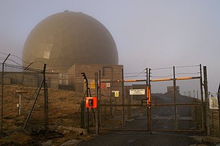
Remote Radar Head Saxa Vord or RRH Saxa Vord, is a Royal Air Force radar station located on the island of Unst, the most northern of the Shetland Islands in Scotland. As of July 2019 it is once more a fully operational radar station, after closure in 2006. The station's motto Praemoneo de Periculis reflects its role. RAF Saxa Vord is further north than Saint Petersburg in Russia, and on the same latitude as Anchorage, Alaska. The station was named after Saxa Vord, which is the highest hill on Unst at 935 ft (285 m). It holds the unofficial British record for wind speed, which in 1992 was recorded at 197 mph (317 km/h) — just before the measuring equipment blew away.

Ground-controlled interception (GCI) is an air defence tactic whereby one or more radar stations or other observational stations are linked to a command communications centre which guides interceptor aircraft to an airborne target. This tactic was pioneered during World War I by the London Air Defence Area organization, which became the Royal Air Force's Dowding system in World War II, the first national-scale system. The Luftwaffe introduced similar systems during the war, but most other combatants did not suffer the same threat of air attack and did not develop complex systems like these until the Cold War era.
Linesman/Mediator was a dual-purpose civil and military radar network in the United Kingdom between the 1960s and 1984. The military side (Linesman) was replaced by the Improved United Kingdom Air Defence Ground Environment (IUKADGE), while the civilian side (Mediator) became the modern public-private National Air Traffic Services (NATS).

Royal Air Force Ash or more simply RAF Ash was a Royal Air Force underground control centre and radar station situated near the village of Woodnesborough, Kent, England.
Royal Air Force Bempton or more simply RAF Bempton is a former Royal Air Force station situated at Bempton in the East Riding of Yorkshire, England, 6 miles (10 km) north of Bridlington. During the Second World War it was established as a radar station, becoming part of the Chain Home Low (CHL) network.

Royal Air Force Goldsborough or more simply RAF Goldsborough is a former Royal Air Force station located in North Yorkshire, England.

Royal Air Force Ventnor or more simply RAF Ventnor is a former Royal Air Force radar station located 0.7 miles (1.1 km) north east of Ventnor on the Isle of Wight, England. It was initially constructed in 1937 as part of a World War II coastal defence programme codenamed Chain Home. The site played an important role during the Second World War, providing early warnings of incoming bomber attacks carried out by the Luftwaffe.
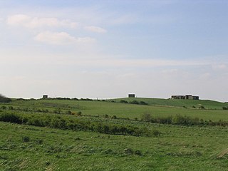
RAF Beachy Head is a former Royal Air Force radar station and one of the many Chain Home Low radar stations, being situated near Beachy Head and Eastbourne in East Sussex, England. It featured a Type 16 radar that was monitored from RAF Kenley.

Remote Radar Head Trimingham or RRH Trimingham is a former TPS-77 radar station situated on the coast in the English county of Norfolk. The site is located on the coast road between Cromer and Mundesley, 1 kilometre east of the village of Trimingham but the activity has now moved to RRH Neatishead due to the threat from coastal erosion. The radar station was a satellite station of RAF Neatishead. This radar station was controlled and maintained by a section of Radar Technicians and Operators and supported by a team of Ground Engineers. Trimingham provided extensive coverage of the East coast of the United Kingdom and helped contribute to the recognised air picture and defence of the United Kingdom. The type 93 became operational on the site in April 1997.

Aird Uig is a village on the Isle of Lewis, in the Outer Hebrides, Scotland. Aird Uig is within the parish of Uig, and is situated on the C40 minor road which joins to the B8011 at Timsgarry. The township includes 700 hectares of common grazings to the east and west of the village.

Royal Air Force Holmpton or more simply RAF Holmpton is a former Royal Air Force Cold War era nuclear bunker that was built in the 1950s as an early warning radar station as part of the ROTOR Radar Defence Programme. Located just south of the village of Holmpton, in the East Riding of Yorkshire, England, RAF Holmpton remained a part of the Defence Estate right up to 8 December 2014 when it was sold into private ownership after 62 years of military service.
RAF Wartling was a Royal Air Force station located near the village of Wartling in East Sussex. It was a Second World War and later Cold War Ground Controlled Interception (GCI) station built to complement the nearby Chain Home station at RAF Pevensey.
RAF Chenies is a former Royal Air Force radar intercept station located 1.4 miles (2.3 km) North of the village of Chenies in Buckinghamshire, built in the 1930s and originally used by RAF Bomber Command during the Second World War repurposed in the 1950s as part of the ROTOR air defence programme.
Royal Air Force Portland or more simply RAF Portland is a former Royal Air Force and ROTOR radar station on the Isle of Portland, Dorset, England. Located close to the Verne Citadel and East Cliff, the station was established in the 1950s as part of a nationwide air defence radar system built by the British Government during the Cold War. The station became a scheduled monument in 2004 and is now the site of the community farm, Fancy's Family Farm.

Royal Air Force Aird Uig was a Royal Air Force radar station located on the western edge of the Isle of Lewis in the Outer Hebrides, Scotland. The main masts and operations room were located north of the village of Aird Uig on Gallan Head, with a separate domestic site nearer to the village, five-eighths mile further south.

The AMES Type 80, sometimes known by its development rainbow code Green Garlic, was a powerful early warning (EW) and ground-controlled interception (GCI) radar developed by the Telecommunications Research Establishment (TRE) and built by Decca for the Royal Air Force (RAF). It could reliably detect a large fighter or small bomber at ranges over 210 nautical miles, and large, high-flying aircraft were seen out to the radar horizon. It was the primary military ground-based radar in the UK from the mid-1950s into the late 1960s, providing coverage over the entire British Isles.
Royal Air Force Hope Cove or more simply RAF Hope Cove is a former Royal Air Force radar station. It is located about 1 mile (1.6 km) south west of Salcombe on the south Devon coast, England, co-located with the former RAF Bolt Head airstrip, which was the RAF closed in 1945 but remains in service for general aviation to this day.

