
Silver Bow County is a county in the U.S. state of Montana. As of the 2020 census, the population was 35,133. Its county seat is Butte. In 1977, the city and county governments consolidated to form the single entity of Butte-Silver Bow. Additionally, the town of Walkerville is a separate municipality from Butte and is within the county.

Madison County is a county in the U.S. state of Montana. As of the 2020 census, the population was 8,623. Its county seat is Virginia City. The county was founded in 1865; at the time it was part of the Montana Territory.

Jefferson County is a county in Montana, United States. As of the 2020 census, the population was 12,085. Its county seat is Boulder. The county was created in 1865 and named for President Thomas Jefferson.
Radersburg is an unincorporated rural village in Broadwater County, Montana, United States.

Four Corners is a census-designated place (CDP) in Gallatin County, Montana, United States. The population was 5,901 at the 2020 census, up from 3,146 in 2010. It is part of the Bozeman, MT Micropolitan Statistical Area.

Willow Creek is a census-designated place (CDP) in Gallatin County, Montana, United States. The population was 210 at the 2010 census. It is part of the Bozeman, MT Micropolitan Statistical Area.

Jefferson City is an unincorporated community and census-designated place (CDP) in Jefferson County, Montana, United States. The population was 472 at the 2010 census. It is part of the Helena Micropolitan Statistical Area.

Augusta is an unincorporated community and census-designated place (CDP) in Lewis and Clark County, Montana, United States. The population was 309 at the 2010 census and rose to 316 in the 2020 census. The most accepted version in the naming of this town is after Augusta Hogan, thought to be the first child born in this town, the daughter of J. D. Hogan, an early rancher.

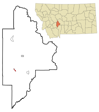
Cardwell is a census-designated place (CDP) in Jefferson County, Montana, United States. The population was 62 at the 2020 census. It is part of the Helena Micropolitan Statistical Area.

Clancy is an unincorporated community and census-designated place (CDP) in Jefferson County, Montana, United States. The population was 1,661 at the 2010 census, up from 1,406 in 2000. It is part of the Helena Micropolitan Statistical Area.
Gallatin Gateway is a census-designated place (CDP) in Gallatin County, Montana, United States. As of the 2010 census it had a population of 856. Elevation is 4,953 ft.
Amsterdam is a census-designated place (CDP) in Gallatin County, Montana, United States. The population was 206 at the 2020 census. It is part of the Bozeman, MT Micropolitan Statistical Area. It was formerly part of the Amsterdam-Churchill CDP.
Turah is an unincorporated community and census-designated place (CDP) in Missoula County, Montana, United States, along Interstate 90. It had a population of 364 as of the 2020 census, up from 306 in 2010.
Wheatland is a census-designated place (CDP) in Broadwater County, Montana, United States. The population was 568 according to the 2010 census.
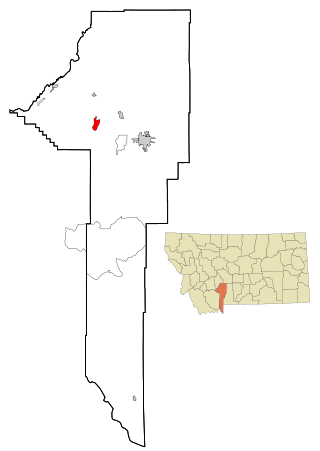
South Hills is a census-designated place (CDP) in Jefferson County, Montana, United States. The population was 517 at the 2010 census.
Bridger is a census-designated place (CDP) in Gallatin County, Montana, United States.

Gilman is an unincorporated community and census-designated place (CDP) in Lewis and Clark County, Montana, United States. It is near the northern border of the county, on the east side of U.S. Route 287. Augusta is less than 2 miles (3 km) to the southwest. US-287 leads northeast from Gilman 24 miles (39 km) to Choteau and south through Augusta 40 miles (64 km) to Interstate 15 near Wolf Creek. Montana Highway 21 forms the southern edge of Gilman and leads east 21 miles (34 km) to Simms.
Brandon is an unincorporated community and census-designated place (CDP) in Madison County, Montana, United States. It is in the northwestern part of the county, at the western base of the Tobacco Root Mountains, in the valley of Mill Creek. Via Mill Creek Road it is 3 miles (5 km) southwest to Sheridan in the Ruby Valley.
Potomac is an unincorporated community and census-designated place (CDP) in Missoula County, Montana, United States. It was first listed as a CDP prior to the 2020 census, at which time it had a population of 26.
Pine Creek is an unincorporated community and census-designated place (CDP) in Park County, Montana, United States. It is in the central part of the county, on the east side of the Paradise Valley, where Pine Creek joins the Yellowstone River.


