
East Godavari is a district in the Coastal Andhra region of Andhra Pradesh, India. Its district headquarters is at Rajamahendravaram.

Rajahmundry, officially known as Rajamahendravaram, is a city in the Indian state of Andhra Pradesh and district headquarters of East Godavari district. It is the fifth most populated city in the state. During British rule, the District of Rajahmundry was created in the Madras Presidency in 1823. It was reorganised in 1859 and bifurcated into the Godavari and Krishna districts. Rajahmundry was the headquarters of Godavari district, which was further bifurcated into East Godavari and West Godavari districts in 1925. When the Godavari district was bifurcated, Kakinada became the headquarters of East Godavari and Eluru became the headquarters of West Godavari. It is administered under Rajahmundry revenue division of the East Godavari district. The city is known for its floriculture, history, culture, agriculture, economy, tourism, and its heritage. It is known as the "Cultural Capital of Andhra Pradesh".

The West Godavari district is a coastal district in the Indian state of Andhra Pradesh with an administrative headquarters in Bhimavaram. As of the 2011 Census of India, the district has an area of 2,178 km2 (841 sq mi) and a population of 1,779,935. It is bounded by the Krishna district and Bay of Bengal to the south, East Godavari district to the east, and Eluru district, Kolleru Lake and Upputeru Drain to the northwest.

Palakollu is a city and the administrative headquarters of Palakollu Mandal in Narasapuram revenue division in West Godavari district of the Indian state of Andhra Pradesh. Palakollu is situated in Coastal Andhra region of the state. It occupies 4.685 square kilometres (1.809 sq mi). As of 2011 census, it had a population of about 61,284 and a Metro population of about 81,199. Palakollu Municipality merged five Grama panchayats of Seven village's on 7 January 2020. The Seven Villages' had a population of 42,932 as of 2011 Census. It around occupies 20.08 square kilometres (7.75 sq mi) and after merged palakollu municipality, It around occupies 24.68 square kilometres (9.53 sq mi) with 35 election wards it is total population of 1,04,216 and making it the third most populous urban area in West Godavari District in Andhra Pradesh. It is a part of Eluru Urban Development Authority.

Tadepalligudem is a city in West Godavari district of the Indian state of Andhra Pradesh. It is a Selection Grade municipality and the mandal headquarters of Tadepalligudem mandal and Tadepalligudem Revenue Division.

Rampachodavaram is a census town in Alluri Sitharama Raju district of the Indian state of Andhra Pradesh. It is located in Rampachodavaram mandal of Rampachodavaram revenue division. Rampachodavaram is known for its dense jungle and waterfalls which can be accessed by road transport only.
Kakinada Rural mandal is one of the 21 mandals in the Kakinada district of the state of Andhra Pradesh, India. It has its headquarters at Kakinada. The mandal is bounded by Samalkota mandal, Pedapudi mandal, Karapa mandal, Kothapalle mandal and waters of Bay of Bengal.
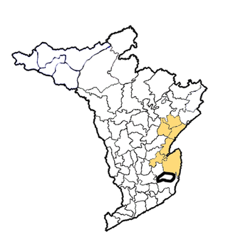
Rajahmundry Rural mandal, officially known as Rajamahendravaram Rural mandal, is one of the 19 mandals in East Godavari district of the state of Andhra Pradesh, India. The mandal is bounded by Seethanagaram mandal, Korukonda mandal, Rajanagaram mandal, Kadiam mandal and Atreyapuram mandal.
Nallajerla is a village in Rajamahendravaram district of the Indian state of Andhra Pradesh.
Penugonda is a town in West Godavari district of the Indian state of Andhra Pradesh.
Peravali is a village in East Godavari district of the Indian state of Andhra Pradesh. The nearest railway station is Tanuku (TNKU) located at a distance of 7.25 Km. Postal index code of this village is 534328
Seethanagaram is one of the 19 mandals in East Godavari district of the state of Andhra Pradesh, India. Its headquarters are located at Seethanagaram. The mandal is bounded by Devipatnam mandal, Korukonda mandal, Rajahmundry (rural) mandal and a part of it lies on the banks of Godavari River. It is sub urban growth of Rajamahendravaram City.
Penikeru is a village of in East Godavari district of the Indian state of Andhra Pradesh. It is located in Alamuru mandal of Rajahmundry revenue division.
Kakinada Urban mandal is one of the 21 mandals in Kakinada district of the state of Andhra Pradesh, India. It has its headquarters at Kakinada city, that covers the entire mandal. The mandal is surrounded by Kakinada (rural) mandal and lies on the coast of Bay of Bengal.
Vijayawada Urban mandal was a mandal in Krishna district of Andhra Pradesh. In 2018 it was bifurcated into 4 mandals under re-organization of revenue mandals and formed Vijayawada Central, Vijayawada North, Vijayawada East and Vijayawada West which were later incorporated into NTR district. It was under the administration of Vijayawada revenue division and has its headquarters at Vijayawada city. The mandal lies on the banks of Krishna River, bounded by Vijayawada (rural) mandal and Penamaluru mandals. The mandal was also a part of the Andhra Pradesh Capital Region under the jurisdiction of APCRDA.
Kovvur mandal is one of the 19 mandals in East Godavari district of the Indian state of Andhra Pradesh. Its headquarters are located in the town of Kovvur. The mandal is bounded by Nidadavole, Chagallu, Devarapalle, Tallapaudi mandals and on the east by the Godavari River.
Dwaraka Tirumala mandal is one of the 28 mandals in Eluru district of the Indian state of Andhra Pradesh. It is under the administration of Eluru revenue division and the headquarters are located at Dwaraka Tirumala. The mandal is bounded by Jangareddygudem, Koyyalagudem, Kamavarapukota, Nallajerla, Pedavegi, Unguturu, Denduluru and Bhimadole mandals.

Biccavolu mandal is one of the 19 mandals in East Godavari district of the Indian state of Andhra Pradesh. It is under the administration of Rajahmundry revenue division and the headquarters are located at Biccavolu village. Biccavolu Mandal is bounded by Rayavaram Mandal towards South, Pedapudi Mandal towards East, Anaparthy Mandal towards west, Ramachandrapuram Mandal towards north. It is located ata distance of 41 kilometres from Rajahhmundry.
Rajanagaram Mandal is one of the 19 mandals in East Godavari District of Andhra Pradesh. As per census 2011, there are 17 villages. Most of the part of Rajanagaram Mandal is under the jurisdiction of "Greater Rajamahendravaram Municipal Corporation (GRMC)". Rajanagaram Mandal has total population of 106,085 as per the Census 2011 out of which 53,345 are males while 52,740 are females and the Average Sex Ratio of Rajanagaram Mandal is 989. The total literacy rate of Rajanagaram Mandal is 64.39%. The male literacy rate is 58% and the female literacy rate is 56.51%.

Konaseema district is one of the 26 districts in the Indian state of Andhra Pradesh. It is situated between the tributaries of the Godavari river in the Konaseema region of Coastal Andhra. It was carved out of East Godavari district on 4 April 2022 by the Government of Andhra Pradesh. Amalapuram is the district headquarters and the largest city in this district. Other significant towns in the district are Mandapeta, Ramachandrapuram, and Mummidivaram.

