
Heathrow Airport, called London Airport until 1966, and now known as London Heathrow, is the main international airport serving London, the capital and most populous city of England and the United Kingdom. It is the largest of the six international airports in the London airport system. The airport is owned and operated by Heathrow Airport Holdings. In 2023, Heathrow was the busiest airport in Europe, the fourth-busiest airport in the world by passenger traffic and the second-busiest airport in the world by international passenger traffic. As of 2023, Heathrow is the airport with the most international connections in the world.

Los Angeles International Airport is the primary international airport serving Los Angeles and its surrounding metropolitan area, in the U.S. state of California. LAX is located in the Westchester neighborhood of the city of Los Angeles, 18 miles southwest of Downtown Los Angeles, with the commercial and residential areas of Westchester to the north, the city of El Segundo to the south, and the city of Inglewood to the east. LAX is the closest airport to the Westside and the South Bay.

An airport is an aerodrome with extended facilities, mostly for commercial air transport. They usually consist of a landing area, which comprises an aerially accessible open space including at least one operationally active surface such as a runway for a plane to take off and to land or a helipad, and often includes adjacent utility buildings such as control towers, hangars and terminals, to maintain and monitor aircraft. Larger airports may have airport aprons, taxiway bridges, air traffic control centres, passenger facilities such as restaurants and lounges, and emergency services. In some countries, the US in particular, airports also typically have one or more fixed-base operators, serving general aviation.

John F. Kennedy International Airport is a major international airport serving New York City and its metropolitan area, in the United States. The airport is located in Queens, New York City. It is the busiest of the seven airports in the New York airport system, the sixth-busiest airport in the United States, and the busiest international commercial airport in North America. The airport, which covers 5,200 acres (2,104 ha), is the largest in the New York metropolitan area.

Indira Gandhi International Airport is the primary international airport serving New Delhi, the capital of India, and the National Capital Region (NCR). The airport, spread over an area of 5,106 acres (2,066 ha), is situated in Palam, Delhi, 15 km (9.3 mi) southwest of the New Delhi Railway Station and 16 km (9.9 mi) from New Delhi city centre.

An IATA airport code, also known as an IATA location identifier, IATA station code, or simply a location identifier, is a three-letter geocode designating many airports and metropolitan areas around the world, defined by the International Air Transport Association (IATA). The characters prominently displayed on baggage tags attached at airport check-in desks are an example of a way these codes are used.

Hartsfield–Jackson Atlanta International Airport is the primary international airport serving Atlanta and its surrounding metropolitan area, in the U.S. state of Georgia. The airport is located 10 mi south of the Downtown Atlanta district. It is named after former Atlanta mayors William B. Hartsfield and Maynard Jackson. The airport covers 4,700 acres of land and has five parallel runways which are aligned in an east-west direction. There are three runways that are 9,000 feet (2,743 m) long, one runway that is 10,000 feet (3,048 m) long, and the longest runway at ATL measures 12,390 feet (3,776 m) long, which can handle the Airbus A380. Since 1998, Hartsfield-Jackson has been the world's busiest airport by passenger traffic. In 2023, the airport served over 104.6 million passengers, the most of any airport in the world. Hartsfield-Jackson is also the world's busiest airport by aircraft movements.

Hong Kong International Airport is an international airport on the island of Chek Lap Kok in western Hong Kong. The airport is also referred to as Chek Lap Kok International Airport or Chek Lap Kok Airport, to distinguish it from its predecessor, the former Kai Tak Airport.
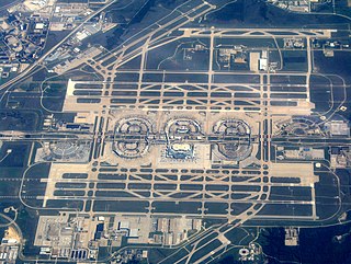
Dallas Fort Worth International Airport is the primary international airport serving the Dallas–Fort Worth metroplex and the North Texas region, in the U.S. state of Texas.

The ICAOairport code or location indicator is a four-letter code designating aerodromes around the world. These codes, as defined by the International Civil Aviation Organization and published quarterly in ICAO Document 7910: Location Indicators, are used by air traffic control and airline operations such as flight planning. ICAO codes are also used to identify other aviation facilities such as weather stations, international flight service stations or area control centers, whether or not they are located at airports. Flight information regions are also identified by a unique ICAO-code.

Toronto Pearson International Airport is an international airport located in Mississauga, Ontario, Canada. It is the main airport serving Toronto, its metropolitan area, and the surrounding region known as the Golden Horseshoe. The airport is named in honour of Lester B. Pearson, who served as the 14th Prime Minister of Canada (1963–1968) and received the Nobel Peace Prize in 1957 for his humanitarian work in peacekeeping.
Rakops, also known as Tsienyane, is a village in Central District of Botswana. It is located south-west of Makgadikgadi Pan, and is served by local Rakops Airport. The population was 6,396 in 2011 census.
Singapore Changi Airport is a major international airport that serves Singapore, and is one of the largest transportation hubs in Asia. More than 100 airlines operate from the airport, with flights to destinations in Asia, Oceania, Africa, Europe, the Middle East, and North America.

Government House refers to the offices of the Prime Minister of Thailand and appointed cabinet ministers. It contains conference rooms and is used for state functions and receptions of foreign guests. It consists of several palace-like structures extending over 11 acres (45,000 m2).
The Nambya people are an ethnic group of about 100,000 people, based in the north-western parts of Zimbabwe and in the north-eastern parts of Botswana. They are found around the coal mining town of Hwange, surrounding areas of the Victoria Falls as well as in the north-eastern parts of Botswana namely, Pandamatenga, Chobe, Maremaoto, Gweta, Shorobe, Tsienyane, Zoroga, Chumo, Makalamabedi, Sankoyo, Lesoma, Xhumo, Mopipi, Broadhurst, Rakops, Shoshong, Palapye and Maun. Hwange Town and the Hwange National Park were named after the BaNambya King Sawanga, who was later called Hwange by the Nambya people. The Kalanga tribes who were captured by the Nambya warriors from the former Rozvi Empire of the Great Zimbabwe influenced the Nambya language which resulted in the changed pronunciation of words and tone.

The Ikuhane people, also known as the Subiya or Subia, are a Bantu-speaking ethnic group native to Southern Africa. They are part of the larger Lozi ethnic group and have significant populations in Botswana, Namibia, and Zambia. Their language is known as the Kuhane language (Chikuhane) or the Subia language (Chisubia), but Silozi is used as the formal language in official, educational, and media contexts.

Narita International Airport, also known as Tokyo-Narita International Airport or simply Narita Airport, formerly and originally known as New Tokyo International Airport, is one of two international airports serving the Greater Tokyo Area, the other one being Haneda Airport (HND). It is about 60 km (37 mi) east of central Tokyo in Narita, Chiba. The facility, since July 2019, covers 1,137 hectares of land and construction to expand to nearly 2,300 ha is under way.

