
Tathong Channel, also known as Nam Tong Hoi Hap, refers to the eastern sea waters in Hong Kong leading into Victoria Harbour through Lei Yue Mun, bounded by Junk Island and Tung Lung Chau in the east, and Hong Kong Island in the west.

The Port of Hong Kong, located by the South China Sea, is a deepwater seaport dominated by trade in containerised manufactured products, and to a lesser extent raw materials and passengers. A key factor in the economic development of Hong Kong, the natural shelter and deep waters of Victoria Harbour provide ideal conditions for berthing and the handling of all types of vessels. It is one of the busiest ports in the world, in the three categories of shipping movements, cargo handled and passengers carried.
Tsing Chau or Pillar Island was an island in the Kwai Chung area of Hong Kong, sitting at the mouth of Gin Drinker's Bay, by the side of the Rambler Channel, opposite Tsing Yi Island.

Rambler Crest is a housing development on Tsing Yi Island, Hong Kong, which includes a private housing estate, shopping mall and 3 hotels, namely Rambler Garden Hotel (華逸酒店), Rambler Oasis Hotel (青逸酒店) and Winland 800 Hotel (永倫800酒店). It was developed by Cheung Kong Holdings. The name Rambler comes from the name of nearby channel, Rambler Channel.

Ma Wan Channel is a channel between Ma Wan and Tsing Yi islands in Hong Kong. The north end of the channel is Ting Kau where it joins the Rambler Channel. To the west it joins with the Kap Shui Mun channel running to the south of Ma Wan, leading into Urmston Road. To the east it divides into the Tsing Yi Channel and the Rambler Channel, leading to Tsuen Wan and Kwai Chung. To the south is the Western Working Anchorage of Victoria Harbour.

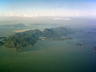
Lei Yue Mun is a short channel in Hong Kong. It lies between Junk Bay and Victoria Harbour, separating Kowloon and Hong Kong Island. The channel is an important passage for the city, forming the eastern entrance of Victoria Harbour.

Tsing Yi Promenade is a promenade along the northeastern seafront of Tsing Yi Island, Hong Kong. It was built in stages from 2001 to 2004.
The Adamasta Channel is a narrow passage between the Chi Ma Wan Peninsula of Lantau Island and Cheung Chau island in Hong Kong. It is one of the few passages in Hong Kong waters with a significant hazard, the Adamasta Rock, in the middle; however, the rock is well marked with a fixed light, and port- and starboard-hand buoys on either side.
Tolo Channel or Chek Mun Hoi Hap is a channel south of Plover Cove in Hong Kong connecting Tolo Harbour to Mirs Bay. At Mirs Bay end, it is named North Channel.

The West Lamma Channel is a sea channel in Hong Kong.
Kwai Tsing Container Terminals is the main port facilities in the reclamation along Rambler Channel between Kwai Chung and Tsing Yi Island, Hong Kong. It evolved from four berths of Kwai Chung Container Port completed in the 1970s. It later expanded with two berths in the 1980s. Two additional terminals are added adjoining to Stonecutters Island in the 1990s and was renamed Kwai Chung Container Terminals. In the 2000s, when Container Terminal 9 on the Tsing Yi Island and was renamed to Kwai Tsing Container Terminals.

Jumbo Kingdom consists of the Jumbo Floating Restaurant (珍寶海鮮舫) and the adjacent Tai Pak Floating Restaurant (太白海鮮舫), are renowned tourist attractions in Aberdeen South Typhoon Shelter, within Hong Kong's Aberdeen Harbour. Over 30 million visitors have visited Jumbo Kingdom, including Queen Elizabeth II, John Wayne, Chad Garvin, David Bowie, Tom Cruise, Gwyneth Paltrow, Chow Yun Fat, Stephen Chow and Gong Li. There was also a Jumbo Kingdom Manila in Manila Bay, Philippines, but it was closed after 8 years of operation. Jumbo Kingdom is part of Melco International Development Limited, a company listed in the Hong Kong Stock Exchange.
Lantau Channel is a channel south of Fan Lau Kok of Lantau Island in Hong Kong. The channel is also on the water boundary between Hong Kong and mainland China. Across the border is the islands of Guishan Dao (桂山島), Niutou Dao (牛頭島) and Zhongxin Dao (中心島) of Wanshan Archipelago.

Aberdeen Channel is a channel between Ap Lei Chau and Nam Long Shan on Hong Kong Island in Hong Kong. With two bays, Po Chong Wan and Tai Shue Wan, major portions of the channel are transformed into Aberdeen South Typhoon Shelter.

Causeway Bay Typhoon Shelter is a typhoon shelter located in Causeway Bay, Hong Kong, between the Hong Kong Island entrance of Cross Harbour Tunnel on Kellett Island and Island Eastern Corridor. It was the first typhoon shelter in Hong Kong. At the present location it is about 14 hectares in area, although it is currently largely filled in, as part of road development works.
Yau Ma Tei Typhoon Shelter is a typhoon shelter located near Yau Ma Tei, Kowloon, Hong Kong.
Riviera Gardens is one of the largest private housing estates in Tsuen Wan, New Territories, Hong Kong.

Kwun Tong Promenade is an urban waterfront park in Kwun Tong, New Kowloon, Hong Kong. Stage 1 and 2 of the project, opened in 2010 and 2015 respectively, is the first open space project of the Kai Tak Development. It is about 1 kilometre in length. It overlooks the Kwun Tong Typhoon Shelter and sits beneath the Kwun Tong Bypass.

