Related Research Articles

Nome Airport is a state-owned public-use airport located two nautical miles (4 km) west of the central business district of Nome, a city in the Nome Census Area of the U.S. state of Alaska.

Charlevoix Municipal Airport is a city-owned, public-use airport located one nautical mile (2 km) southwest of the central business district of Charlevoix, a city in Charlevoix County, Michigan, United States. It is mostly used for general aviation, but also offers passenger service to Beaver Island via Island Airways and Fresh Air Aviation.
Fitch H. Beach Airport is a city-owned, public-use airport located two nautical miles (3.7 km) northeast of the central business district of Charlotte, a city in Eaton County, Michigan, United States. It is included in the Federal Aviation Administration (FAA) National Plan of Integrated Airport Systems for 2017–2021, in which it is categorized as a local general aviation facility.
University Airpark is a privately-owned, public use general aviation airport located 2 miles (3 km) west-northwest of Bath, Michigan in Clinton County, Michigan, United States. Lansing Capital Region International Airport is located 6 miles (10 km) southwest.
Tuscola Area Airport is a public use airport located three nautical miles (6 km) southwest of the central business district of Caro, a city in Tuscola County, Michigan, United States. It is owned by the Tuscola Area Airport Authority. It is included in the Federal Aviation Administration (FAA) National Plan of Integrated Airport Systems for 2017–2021, in which it is categorized as a local general aviation facility. Many U.S. airports use the same three-letter location identifier for the FAA and IATA. However, this airport is assigned CFS by the FAA but has been assigned TZC from the IATA. Note that CFS was assigned to Coffs Harbour Airport in Coffs Harbour, New South Wales, Australia.

Grayling Army Airfield is a public/military use airport located one nautical mile (1.85 km) northwest of the central business district of Grayling, in Crawford County, Michigan, United States. It is owned by United States Army. The airfield is located 7 miles (11 km) northeast of the main cantonment area of Camp Grayling. It is included in the Federal Aviation Administration (FAA) National Plan of Integrated Airport Systems for 2017–2021, in which it is categorized as a general aviation facility.
Pittsburgh Northeast Airport is a privately owned, public use airport in Allegheny County, Pennsylvania, United States. The airport is located 12 nautical miles north-northeast of the central business district of Pittsburgh, in West Deer Township. The airport is located a few miles north of Pittsburgh Mills shopping mall.
Mason County Airport is a county-owned public-use airport located two miles northeast of the central business district of Ludington, a city in Mason County, Michigan, United States.

Avon Park Executive Airport is a city-owned, public-use airport located two nautical miles (3.7 km) west of the central business district of Avon Park, a city in Highlands County, Florida, United States.

Oakland Southwest Airport is a county-owned public-use airport in Oakland County, Michigan, United States. It is located one nautical mile (1.85 km) southwest of the central business district of New Hudson. The airport is uncontrolled, and is used for general aviation purposes.
David's Airport, also known as David's Field, is a privately owned, public-use airport located in Branch County, Michigan, United States. It is two miles (3 km) south of the central business district of Athens, a village in Calhoun County. David's Field was built shortly after World War II by John Broberg and named to honor his twin brother who was killed on Okinawa. John operated the field intermittently into the 1970s where he conducted flight training and parachute practice operations.
Mount Pleasant Municipal Airport is a city-owned public-use airport located two miles (3 km) northeast of the central business district of Mount Pleasant, a city in Isabella County, Michigan, United States. The airport became active in 1940. It serves general aviation for Mount Pleasant and the surrounding area. It is included in the Federal Aviation Administration (FAA) National Plan of Integrated Airport Systems for 2017–2021, in which it is categorized as a local general aviation facility.

Tuntutuliak Airport is a state-owned public-use airport located one nautical mile (1.85 km) south of the central business district of Tuntutuliak, in the Bethel Census Area of the U.S. state of Alaska.

Belleville Airport is a privately-owned, public-use airport located three miles southwest of Belleville, Michigan in Washtenaw County. It is owned and operated by Kenney Farmer. It is at an elevation of 696 feet. The airport was formerly named the Larsen Airpark.

Merillat Airport is a public use airport located three nautical miles (6 km) southeast of the central business district of Tecumseh, in Lenawee County, Michigan, United States. It is owned by James N. Merillatt and managed by Jeff Wright. The airport opened in February 1976. "The Landing" banquet hall is adjacent to the airport on N. Rogers Rd.
Johnson Field is a privately owned, public use airport located one nautical mile (1.85 km) northeast of the central business district of Smiths Creek, in St. Clair County, Michigan, United States.
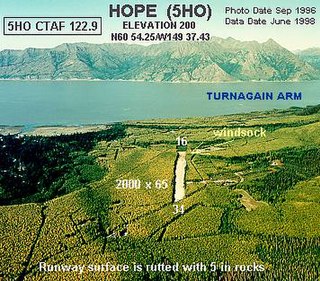
Hope Airport is a state-owned public-use airport located one nautical mile southeast of the central business district of Hope, in the Kenai Peninsula Borough of the U.S. state of Alaska. This airport is included in the FAA's National Plan of Integrated Airport Systems for 2011–2015, which categorized it as a general aviation facility.
Hastings Airport is a public use airport located three nautical miles (6 km) west of the central business district of Hastings, a city in Barry County, Michigan, United States. It is owned by the city and county and is also known as Hastings City/Barry County Airport.
Greenville Municipal Airport is a city-owned, public-use airport located three nautical miles (6 km) south of the central business district of Greenville, a city in Montcalm County, Michigan, United States. It is included in the Federal Aviation Administration (FAA) National Plan of Integrated Airport Systems for 2017–2021, in which it is categorized as a local general aviation facility.
The Greensburg Jeannette Regional Airport is a privately owned, public use airport which is located three nautical miles (6 km) north of the central business district of Jeannette, a city in Westmoreland County, Pennsylvania, United States.
References
- 1 2 3 4 FAA Airport Form 5010 for 61G PDF . Federal Aviation Administration. effective July 31, 2008.
- 1 2 "Saint Johns, Randolph's (61G)" (PDF). Airport Directory. State of Michigan.