
The Moray Firth is a roughly triangular inlet of the North Sea, north and east of Inverness, which is in the Highland council area of north of Scotland. It is the largest firth in Scotland, stretching from Duncansby Head in the north, in the Highland council area, and Fraserburgh in the east, in the Aberdeenshire council area, to Inverness and the Beauly Firth in the west. Therefore, three council areas have Moray Firth coastline: Highland to the west and north of the Moray Firth and Highland, Moray and Aberdeenshire to the south. The firth has more than 800 kilometres of coastline, much of which is cliff.

Forres is a town and former royal burgh in the north of Scotland on the Moray coast, approximately 25 miles (40 km) northeast of Inverness and 12 miles (19 km) west of Elgin. Forres has been a winner of the Scotland in Bloom award on several occasions. There are many geographical and historical attractions nearby such as the River Findhorn, and there are also classical, historical artifacts and monuments within the town itself, such as Forres Tolbooth and Nelson's Tower. Brodie Castle, the home of the Brodie Clan, lies to the west of the town, close to the A96.

Moray or Morayshire, called Elginshire until 1919, is a historic county, registration county and lieutenancy area of Scotland, bordering Nairnshire to the west, Inverness-shire to the south, and Banffshire to the east. It was a local government county, with Elgin the county town, until 1975. The county was officially called Elginshire, sharing the name of the Elginshire parliamentary constituency, so named since 1708.
The title Earl of Moray, Mormaer of Moray or King of Moray was originally held by the rulers of the Province of Moray, which existed from the 10th century with varying degrees of independence from the Kingdom of Alba to the south. Until 1130 the status of Moray's rulers was ambiguous and they were described in some sources as "mormaers", in others as "Kings of Moray", and in others as "Kings of Alba". The position was suppressed by David I of Scotland some time after his defeat of Óengus of Moray at the Battle of Stracathro in 1130, but was recreated as a feudal earldom by Robert the Bruce and granted to Thomas Randolph, 1st Earl of Moray in 1312.

The First War of Scottish Independence was the first of a series of wars between English and Scottish forces. It lasted from the English invasion of Scotland in 1296 until the de jure restoration of Scottish independence with the Treaty of Edinburgh–Northampton in 1328. De facto independence was established in 1314 at the Battle of Bannockburn. The wars were caused by English kings attempting to establish their authority over Scotland while Scots fought to keep English rule and authority out of Scotland.
Findhorn is a village in Moray, Scotland. It is located on the eastern shore of Findhorn Bay and immediately south of the Moray Firth. Findhorn is 3 miles (5 km) northwest of Kinloss, and about 5 miles (9 km) by road from Forres.

Kinloss is a village in Moray, Scotland. It is located near the shore of Findhorn Bay, around 3 miles (5 km) from Findhorn and 2.5 miles (4 km) from Forres. Northeast of the village is Kinloss Barracks, formerly RAF Kinloss which opened on 1 April 1939.

Moray is a county constituency of the House of Commons of the Parliament of the United Kingdom. It elects one Member of Parliament (MP) by the first past the post system of election.
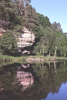
The River Findhorn is one of the longest rivers in Scotland. Located in the north east, it flows into the Moray Firth on the north coast. It has one of the largest non-firth estuaries in Scotland.

The River Lossie is a river in north east Scotland. The river originates in the hills above Dallas, in Moray, and has its source 400 metres (1,300 ft) above sea-level. It enters the sea at Lossiemouth on the Moray Firth. By the time it moves through Elgin its rate of flow, in normal conditions, is best described as very slow. The gradient between Elgin and Lossiemouth is almost imperceptible with a total fall of less than 5 metres (16 ft).
The Battle of Corrichie, also known as the Battle of Corrichy was a battle fought near Meikle Tap, near Aberdeen, Scotland, on 28 October 1562. It was fought between the forces of George Gordon, 4th Earl of Huntly, chief of Clan Gordon, against the forces of Mary, Queen of Scots, under James Stewart, 1st Earl of Moray.
The Muckle Spate was a great flood in August 1829, which devastated much of Strathspey, in the north east of Scotland.
Forres Academy is a comprehensive community school serving the town of Forres, Scotland, and its rural catchment area in west Moray. Similar to other Scottish schools pupils are able to leave after the fourth year of schooling, therefore fifth and sixth year are non compulsory.
Culbin Sands, Forest and Findhorn Bay is a huge area of coast and countryside and an SSSI in Moray, Scotland, stretching from just east of the town of Nairn eastwards to the village of Findhorn and its bay. All of the areas are very important for wildlife in general and are strongly protected by law. The Culbin Sands are known in Gaelic as Bar Inbhir Èireann.

Darnaway Castle, also known as Tarnaway Castle, is located in Darnaway Forest, 3 miles (4.8 km) southwest of Forres in Moray, Scotland. This was Comyn land, given to Thomas Randolph along with the Earldom of Moray by King Robert I. The castle has remained the seat of the Earls of Moray ever since. Rebuilt in 1810, it retains the old banqueting hall, capable of accommodating 1,000 men.
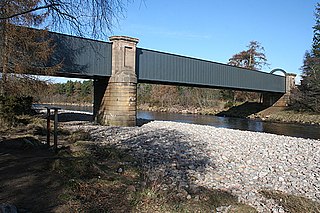
The Findhorn Viaduct is a railway bridge near Forres in Moray, Scotland. Built for the Inverness & Aberdeen Junction Railway between 1856 and 1858 by Joseph Mitchell, with ironwork by William Fairbairn & Sons of Manchester, the viaduct carries the railway line over the River Findhorn approximately 1.7 km west of the town of Forres.

The Findhorn Viaduct is a railway bridge approximately 500 metres east of the village of Tomatin in the Scottish Highlands, which carries the Perth to Inverness railway line over the valley of the River Findhorn.
Dunphail Castle is a ruined 14th-century tower house, about 6.5 miles (10.5 km) south of Forres, Moray, Scotland, west of nearby Dunphail House, and east of the River Divie.

